Kondapalli

Last updated

Kondapalli
Kondapalli killa 18.jpg
Kondapalli aerial view
Kondapalli
Interactive map
India Andhra Pradesh location map (current).svg
Red pog.svg
Kondapalli
Location in Andhra Pradesh, India
Coordinates: 16°37′06″N80°32′28″E / 16.61833°N 80.54111°E / 16.61833; 80.54111
CountryFlag of India.svg  India
State Andhra Pradesh
District NTR district
Mandal Ibrahimpatnam
City Vijayawada
Incorporated (Municipality)30 January 2020
Government
  Type Mayor-council
  BodyKondapalli Municipality
Area
  Total30.00 km2 (11.58 sq mi)
Population
 (2011)
  Total33,373
  Density1,100/km2 (2,900/sq mi)
Languages
  Official Telugu
Time zone UTC+5:30 (IST)
PIN
521228
Telephone code+91-866
Vehicle registration AP-16
Kondapalli toys at a house in Vijayawada Kondapalli toys at a house in Vijayawada.jpg
Kondapalli toys at a house in Vijayawada
Forecourt of the fort Fourcourt.JPG
Forecourt of the fort

Kondapalli is an industrial and residential hub located in western part of Vijayawada in the Indian state of Andhra Pradesh. Dr Narla Tata Rao Thermal Power Station, one of the major Thermal Power stations of the state is located in between Ibrahimpatnam and Kondapalli. It is home for many industries like Andhra Pradesh Heavy Machinery & Engineering Limited (APHMEL), BPCL, HPCL, IOC, Reliance Industries, Lanco Infratech are located here. 
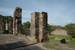
Kondapalli Toys are very famous in the state. Kondapalli Fort, also known as Kondapalli Kota, is located towards west of Kondapalli. The closest locality to Kondapalli is Ibrahimpatnam.

Contents

Etymology

In 18th century, Kondapalli was known with the name, Mustafanagar. [1]

Culture

The village is known for Kondapalli Toys (Kondapalli bommalu). The toys are chiselled from local light softwoods (Tella Poniki) and painted with vegetable dyes, and vibrant enamel colours. They are made by local wooden and lay artisans. The most popular toys include Dasavatarams (ten incarnations of Lord Vishnu) elephants with Ambari, palanquin-bearers carrying the bride and bridegroom, toddy tapper, set of village craftsmen, as well as various animals. The papier mache swinging doll is a favourite with many. [2]

Fort

Flora and fauna

Kondapalli is home to the Kondapalli Reserve Forest one of the last remaining pristine forests in the Krishna district, spread over an area of 30,000 acres (120 km2). It is home to several leopards, wild dogs, jackals, wild boar, and wolves with a varied topography. [3] A Zoological park was also planned by the state government at the village. [4]

Economy

Kondapalli is an industrial suburb of Vijayawada. It has one of the largest industrial estates (industrial parks) in Andhra Pradesh, spread over 450 acres (1.8 km2) and supporting over 800 industrial enterprises. Second largest wagon workshop of Indian Railways is present in Rayanapadu (Guntupalli) about 3 km (1.9 mi) from Kondapalli. [5] In addition to a 1760 MW Dr Narla Tata Rao Thermal Power Station (NTTPs) and 368.144 MW gas based Lanco power plant which is under expansion to 768.144 MW are located here. [6] Andhra Pradesh Heavy Machinery & Engineering Limited (APHMEL) factory is present in Kondapalli. Kondapalli is hub for storage, bottling and transportation of petroleum products of all major companies. Major companies having a presence in Kondapalli include BPCL, GAIL, HPCL, IOC, Reliance Industries, and Lanco Infratech.

Transport

Kondapalli ghat road Kondapalli ghat road.jpg
Kondapalli ghat road

Kondapalli railway station is located on Kazipet–Vijayawada section, administered under Vijayawada railway division of South Central Railway zone. [7] NH 30 passes through the town, which connects Vijayawada with Uttarakhand. APSRTC operates city buses from Kondapalli to other places of the city. APSRTC City Bus Routes

Route NumberStartEndVia
144KondapalliAuto NagarIbrahimpatam,Gollapuri,City Terminal,Governorpet,M.G Road, Libbipet, Benz circle, Patamata
145KondapalliNidamanuruIbrahimpatnam, Gollapuri,City Terminal, Maruthinagar, gunadala, Ramavarapadu, Nidamanuru,
145GKondapalli Railway StationGannavaramKondapalli Railway Station, City Terminal, Gunadala, Ramavarapadu, Prasadampadu, Enkepadu, Nidamanuru, Kesarapalli, Gannavaram
150KondapalliKankipaduIbrahimpatam,Gollapuri,City Terminal,Governorpet,M.G Road, Libbipet, Benz circle, Patamata, Tadigadapa,Penamaluru
188Kondapalli Railway StationGannavaramKondapalli Railway Station, Ibrahim patnam, City Terminal,Gunadala, Ramavarappadu, Gannavaram Centre Bus Stop
200Kondapalli KhillaCity TerminalKondapalli Railway Station, Ibrahim patnam, City Terminal

Education

The primary and secondary school education is imparted by government, aided and private schools, under the School Education Department of the state. [8] [9] The medium of instruction followed by different schools are English and Telugu.

See also

Related Research Articles

<span class="mw-page-title-main">Mangalagiri</span> Municipal Corporation in Andhra Pradesh, India

Mangalagiri is a major Sub-urban of Vijayawada in Guntur district of Indian state of Andhra Pradesh. The town is a part of Mangalagiri Tadepalli Municipal Corporation and part of Tenali revenue division. It and a part of Andhra Pradesh Capital Region. It is situated on National Highway 16 between Vijayawada and Guntur.

<span class="mw-page-title-main">Krishna district</span> District in Andhra Pradesh, India

Krishna district is a district in the coastal Andhra Region in Indian state of Andhra Pradesh, with Machilipatnam as its administrative headquarters. It is surrounded on the East by Bay of Bengal, West by Guntur, Bapatla and North by Eluru and NTR districts and South again by Bay of Bengal.

<span class="mw-page-title-main">Vijayawada</span> Metropolis in Andhra Pradesh, India

Vijayawada, formerly known as Bezawada, is the second largest city in the Indian state of Andhra Pradesh. It is located on the banks of the Krishna River surrounded by the hills of the Eastern Ghats, known as the Indrakeeladri Hills. The city is home to the important Hindu shrine of Kanaka Durga Temple. It geographically lies on the center spot of Andhra Pradesh. The city has been described as the commercial, political, cultural and educational capital of Andhra Pradesh. It is the administrative headquarters of NTR district. The Prakasam Barrage across the Krishna River connects the NTR and Guntur districts.

<span class="mw-page-title-main">Gannavaram, Vijayawada</span> Suburb in Krishna, Andhra Pradesh, India

Gannavaram is a suburb of Vijayawada in Krishna district of the Indian state of Andhra Pradesh. It is also the mandal headquarters of Gannavaram mandal which is administered under Gudivada revenue division. It is a major suburb of Vijayawada in the North East side.Vijayawada International Airport, Medha IT Park, IT companies like HCL Tech and TechMahindra are located here.

<span class="mw-page-title-main">Narsipatnam</span> City in Andhra Pradesh, India

Narsipatnam is a census town in Anakapalle district of the Indian state of Andhra Pradesh. It was upgraded from a gram panchayat into municipality in 2012. The town is spread over an area of 42 km2 (16 sq mi) The resting place of the revolutionary Indian freedom fighter Alluri Sitarama Raju is located in Krishna Devi Peta village of From Narsipatnam to labasingi Village 30 km only.. labasingi most popular winter tourism place..so many Tourists enjoy -2 degree's temparature there.. Narsipatnam town is 43 km away from Tuni. And it is 72 km away from Visakhapatnam.

Kankipadu is a suburb of Vijayawada and a in Krishna District of the Indian state of Andhra Pradesh. It is also the mandal headquarters of Kankipadu mandal in Vuyyuru revenue division.

<span class="mw-page-title-main">Andhra Pradesh State Road Transport Corporation</span> Indian state bus operator

Andhra Pradesh State Road Transport Corporation, officially Andhra Pradesh Raastra Roadu Ravaana Samstha, is the state-owned road transport corporation in the Indian state of Andhra Pradesh. Its headquarters is located at NTR Administrative Block of RTC House in Pandit Nehru bus station of Vijayawada. Many other Indian metro towns in Telangana, Tamil Nadu, Karnataka, Odisha, Yanam, Kerala, Maharashtra and Chhattisgarh are also linked with the APSRTC services.

<span class="mw-page-title-main">Ibrahimpatnam</span> Neighbourhood in NTR, Andhra Pradesh, India

Ibrahimpatnam is a part of Vijayawada in NTR district of the Indian state of Andhra Pradesh. It is also the mandal headquarters of Ibrahimpatnam mandal. The Dr Narla Tata Rao Thermal Power Station, one of the major thermal power stations of the state, is located near the town. The Railway Wagon Workshop at Rayanapadu is also located very near to Ibrahimpatnam at a distance of 4 km.

<span class="mw-page-title-main">Narasannapeta</span> Census Town in Andhra Pradesh, India

Narasannapeta is a census town in Srikakulam district of the Indian state of Andhra Pradesh. It is the mandal headquarters of Narasannapeta mandal in Srikakulam revenue division. 43 villages are there under the administrative division of Narasannapeta.

<span class="mw-page-title-main">Payakaraopeta</span> City in Andhra Pradesh, India

Payakaraopeta is a City in anakapalli district in the state of Andhra Pradesh in India. Payakaraopeta City is a gate Way of Visakhapatnam. Tuni and Payakaraopeta Cities are Twin Cities in Andhra Pradesh. Payakaraopeta City is fastest growing City in Andhra Pradesh. In the year 2011, The first AC library in united Andhra Pradesh was opened here.

Narla Tata Rao was a prominent person in the power sector of India and a former chairman of the Andhra Pradesh State Electricity Board.

Mulapadu is a village in NTR district of the Indian state of Andhra Pradesh. It is located in Ibrahimpatnam mandal under Vijayawada revenue division.

Chilakaluripet is a city in Palnadu district of the Indian state of Andhra Pradesh. It is the Mandal headquarters of Chilakaluripet Mandal in Narasaraopet Revenue Division.

<span class="mw-page-title-main">Guntupalli, NTR district</span> Census Town in Andhra Pradesh, India

Guntupalli is located in western part of Vijayawada in the Indian state of Andhra Pradesh. It is a Rural area falls under Ibrahimpatnam mandal in Vijayawada revenue division of NTR district. Guntupalli Railway Wagon Workshop is located here. There is a proposal to merge this village into Vijayawada Municipal Corporation (VMC) to form a Greater Vijayawada Municipal Corporation.

<span class="mw-page-title-main">Dr. Narla Tata Rao Thermal Power Station</span> Building in India

Dr. Narla Tata Rao Thermal Power Station or Vijayawada Thermal Power Plant is located at Vijayawada in Andhra Pradesh. It is named after, Narla Tata Rao, the erstwhile chairman of the Andhra Pradesh State Electricity board. The power plant is one of the coal-based power plants of APGENCO. It is well placed between Ibrahimpatnam and Kondapalli villages.

Lanco Infratech was a large Indian conglomerate that became insolvent in 2017. It was involved in construction, power, real estate, and several other segments. One of the first Independent Power Producers (IPP) in India, in 2011 it became the largest private power provider in India.

<span class="mw-page-title-main">Economy of Vijayawada</span>

Vijayawada is the second-largest city in the state of Andhra Pradesh of India. It is one of the Tier-II cities and is categorized under the B-1 graded cities of India. Factors contributing to its economic growth include agricultural exports, tourism, resources, industries and transportation etc. The economy depends largely on trade and commerce, which provides entrepreneurial growth. About 70% of working people are involved in tertiary activities. According to one study, the GDP of the city in 2010 was $3 billion and is expected to grow up to $17 billion by 2025. According to another by Oxford the GDP of the city in 2018 was $5.8 billion and is expected to grow up to $21 billion by 2035.

Kondapalli railway station is an Indian Railways station in Kondapalli, Vijayawada of Andhra Pradesh. It lies on Kazipet - Vijayawada section of New Delhi - Chennai main line. It is administered under Vijayawada railway division of the South Central Railway zone. It is used as a satellite station to reduce congestion of the rail traffic on Vijayawada Junction.

Ibrahimpatnam mandal is one of the 20 mandals that constitute the NTR district of the State of Andhra Pradesh in India. It is under the administration of the Vijayawada revenue division and the mandal headquarters are located at Ibrahimpatnam town. The mandal is located on the banks of Krishna River and is bounded by Kanchikacherla, Veerullapadu, G. Konduru and Vijayawada (rural) mandals. The mandal is also a part of the Andhra Pradesh Capital Region under the jurisdiction of APCRDA.

<span class="mw-page-title-main">NTR district</span> District in Andhra Pradesh, India

NTR district is a district in coastal Andhra Region in the Indian state of Andhra Pradesh. The district headquarters is located at Vijayawada. The district is named after former Chief Minister of Andhra Pradesh N. T. Rama Rao. The district shares boundaries with Guntur, Palnadu, Krishna, Eluru, Khammam and Suryapet districts

References

  1. Swarnalatha, P. (2005). The World of the Weaver in Northern Coromandel, C.1750-c.1850. Orient Blackswan. p. 11. ISBN   9788125028680.
  2. Somya, J. N.; Des, M. "Design Resources on Traditional Toys of Kondapalli The Craft of Wooden Toys". Visual Communication Industrial Design Centre (IDC), IIT Bombay. Archived from the original on 16 October 2012. Retrieved 2 February 2013.
  3. Rao, G. V. Ramana (25 May 2006). "Presence of leopards, wild dogs detected in Krishna forests". The Hindu . Chennai (Madras), Tamil Nadu. Archived from the original on 27 November 2007.
  4. Rao, G. v r Subba (27 November 2018). "World-class zoo at Kondapalli soon". The Hindu. Retrieved 13 June 2019.
  5. "Wagon Workshop, Guntupalli". South Central Railway. Archived from the original on 15 January 2013.
  6. "It is always better to spread your wings". The Financial Express. 31 March 2008.
  7. "Overview of Kondapalli Station". indiarailinfo. Retrieved 13 January 2015.
  8. "School Education Department" (PDF). School Education Department, Government of Andhra Pradesh. Archived from the original (PDF) on 27 December 2015. Retrieved 7 November 2016.
  9. "The Department of School Education – Official AP State Government Portal | AP State Portal". www.ap.gov.in. Archived from the original on 7 November 2016. Retrieved 7 November 2016.