
Krishna district is a district in the coastal Andhra Region in Indian state of Andhra Pradesh, with Machilipatnam as its administrative headquarters. It is surrounded on the East by Bay of Bengal, West by Guntur, Bapatla and North by Eluru and NTR districts and South again by Bay of Bengal. In 2022 Krishna district was divided into Krishna and NTR districts.
Malkajgiri also known as Mallikarjuna Giri is a suburb of Hyderabad, Telangana, India. It is located in Medchal–Malkajgiri district and also Sub-District in Medchal District is the headquarters of Malkajgiri mandal in Malkajgiri revenue division. Erstwhile Malkajgiri Major Grampanchayat was upgraded to a municipality in 1965 and became a municipal corporation in 1985. It was merged into the Greater Hyderabad Municipal Corporation in 2007. It was a part of Ranga Reddy district before the re-organisation of districts in 2016.
Panchayat samiti or block panchayat is a rural local government (panchayat) body at the intermediate tehsil (taluka/mandal) or block level in India. It works for the villages of the tehsil that together are called a development block. It has been said to be the "panchayat of panchayats".

Padmanabham mandal is one of the 46 mandals in Visakhapatnam District in India. It is under the administration of Bhemunipatnam revenue division and the headquarters is located at Padmanabham. The Mandal is bounded by Bheemunipatnam, Anandapuram mandals in Visakhapatnam District and Bhogapuram mandal in Vizianagaram District. Great freedom fighter Alluri Sitarama Raju was born in Pandrangi village in this Mandal.Rajasagi Suryanarayana Raju, MLA Bheemili from 1972–78 is from this Mandal. Also Rajasagi Appalanarasimha Raju MLA Bheemili from 1985 to 2004 is also from this Mandal.
Tirupati Urban mandal is one of the 34 mandals in Tirupati district of the Indian state of Andhra Pradesh. It has its headquarters at Tirupati city&Tirupati district. The mandal is bounded by Chandragiri, Tirupati (rural) mandals. A part of it also borders Annamayya district.
Venkatapur is a village and a mandal in Mulugu district in the state of Telangana, India. It is the second-largest revenue village of the district, comprising around 12,000 people.
Awaradi is a village in the Ramdurg Taluka of Belgaum district in the southern state of Karnataka, India. Shree Falaharshivyogiswar Math is famous in Avaradi Village, also a fete a famous festival of Falahareswar conducted in every December month on the Hostil full moon(ಹುಣ್ಣಿಮೆ). And also other temples in Avaradi, Durgadevi and choudeswari temple, Malingeswar temple, Basaveswer temple, Kalika Devi temple etc. Avaradi is located in the bank of the Malaprabha river, Avaradi is also famous in local yuvak Mandal,samara simha sangolli rayanna yuvak mandal, Shree Durga Devi yuvak mandal, Ambedkar Yuvak Mandal, Shree Falahareswer Yuvak Mandal, Mruttunjeya Yuvak Mandal, Basaweswer Yuvak Mandal, etc., these yuvak Mandals are conducted many sports entertainment programs in Avaradi. Shree Falahareswar math established many education trusts at avaradi, sureban(tq.Ramadurg), Menasagi(tq.Rona), and Naragunda(Di. GADAG). Gram panchayat in Avaradi village and 6000 population(2011) in this village. Government primary school and Shree Falahareswer Anupam viday mandir are educational schools they are 1st std to 7th standard.

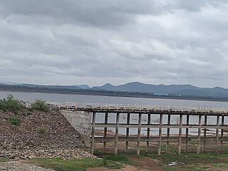
Repalle mandal is one of the 25 mandals in Bapatla district of the state of Andhra Pradesh, India. It is under the administration of Bapatla revenue division and the mandal headquarters are located at Repalle. The mandal is situated on the banks of Krishna River of Velanadu region and is bounded by Bhattiprolu, Nagaram and Nizampatnam mandals.
Kota mandal is one of the 34 mandals in Tirupati district of the state of Andhra Pradesh in India. Its headquarters are located at Kota. The mandal is bounded by Muthukur mandal, Chillakur, Ojili, Chittamur, Vakadu mandals and it also borders Nellore district.
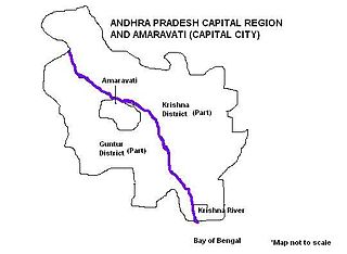
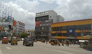
Andhra Pradesh Capital Region is the metropolitan area of the defacto capital city Amaravati of Andhra Pradesh in India. The region is spread across the districts of NTR, Krishna, Guntur, Palnadu, Bapatla and Eluru. It includes the major ancient cities of Vijayawada, Guntur and Tenali. Vijayawada is the largest city and headquarters of the region. It is one the most populated metropolitan area in Andhra Pradesh. The region is under the jurisdiction of Andhra Pradesh Capital Region Development Authority and covers an area of 8,352.69 km2 (3,224.99 sq mi) under 58 mandals . The defacto capital city Amaravati is an urban notified area and will cover 217.23 km2 (83.87 sq mi), within the Andhra Pradesh Capital Region.
Makkuva mandal is one of the 34 mandals in Parvathipuram Manyam district of the Indian state of Andhra Pradesh. It is administration under Parvathipuram revenue division and headquartered at Makkuva. The mandal is bounded by Salur mandal on South & West, Parvathipuram mandal on North, Seethanagaram mandal on east and Bobbili mandal on south east. A portion of it also borders the Narayanapatna block of the Koraput district of Odisha on north west.
Mancherial district is a district located in the northern region of the Indian state of Telangana. The district comprises 18 mandals and two revenue divisions – Mancherial and Bellampalli. The district headquarters is located at Mancherial town. It is surrounded by Komaram Bheem, Nirmal, Jagtial, Peddapalli and Bhupalpally districts of Telangana and with Maharashtra state.

Sangareddy district, is a district in the Indian state of Telangana. This district contains a part of the Hyderabad Metropolitan Region. The district shares boundaries with Medak, Medchal, Vikarabad, Kamareddy and Rangareddy districts and with the state boundary of Karnataka.

Warangal district, formerly Warangal Rural district, is a district in the Indian state of Telangana. The district shares boundaries with Mahabubabad, Jangaon, Hanamkonda, Mulugu and Bhupalpally districts.
Mahabubabad district is a district in the Indian state of Telangana. The district was carved out from the erstwhile Warangal district following the re-organisation of districts in the state in October 2016. The district shares boundaries with Suryapet, Khammam, Bhadradri, Warangal, Mulugu and Jangaon districts.
Jayashankar Bhupalpally district is a district in the Indian state of Telangana. The district headquarters are located at Bhupalpally. It was a part of the erstwhile Warangal district and Karimnagar district prior to the re-organisation of districts in the state. The district share boundaries with Karimnagar, Mancherial, Peddapalli, Hanamkonda, Warangal, and Mulugu districts and with the state boundary of Maharashtra and Chhattisgarh.

