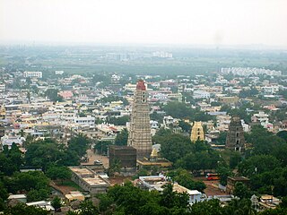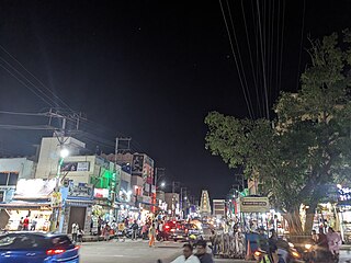
Mangalagiri is a major Sub-urban of Vijayawada in Guntur district of Indian state of Andhra Pradesh. The town is a part of Mangalagiri Tadepalli Municipal Corporation and part of Tenali revenue division. It and a part of Andhra Pradesh Capital Region. It is situated on National Highway 16 between Vijayawada and Guntur.

Krishna district is a district in the coastal Andhra Region in Indian state of Andhra Pradesh, with Machilipatnam as its administrative headquarters. It is surrounded on the East by Bay of Bengal, West by Guntur, Bapatla and North by Eluru and NTR districts and South again by Bay of Bengal.

Srikakulam is a city and the headquarters of Srikakulam district in the Indian state of Andhra Pradesh. As of 2011 census, it has a population of 165,735. There are many other places of Buddhist Tourism such as Salihundam, Kalinga Patnam, Dabbaka Vaani Peta, Nagari Peta, Jagati Metta, Singupuram etc. in Srikakulam District. The Buddhist heritage site of Salihundam has some unique features. It has a beautiful star atop a stupa, rock cut massive stupas inside chaitya grihas, brick stupas with wheel pattern plan, votive stupas, inscriptions on the steps leading to the stupas and museum housing over two dozen sculpted statue and figurines of Buddha, Jain Teerthankars and other deities.

Machilipatnam, also known as Masulipatnam and Bandar, is a city in Krishna district of the Indian state of Andhra Pradesh. It is a municipal corporation and the administrative headquarters of Krishna district. It is also the mandal headquarters of Machilipatnam mandal in Machilipatnam revenue division of the district. The ancient port town served as the settlement of European traders from the 16th century, and it was a major trading port for the Portuguese, British, Dutch and French in the 17th century.

Palakollu is a city and the administrative headquarters of Palakollu Mandal in Narasapuram revenue division in West Godavari district of the Indian state of Andhra Pradesh. Palakollu is situated in Coastal Andhra region of the state. It occupies 4.685 square kilometres (1.809 sq mi). As of 2011 census, it had a population of about 61,284 and a Metro population of about 81,199. Palakollu Municipality merged five Grama panchayats of Seven village's on 7 January 2020. The Seven Villages' had a population of 42,932 as of 2011 Census. It around occupies 20.08 square kilometres (7.75 sq mi) and after merged palakollu municipality, It around occupies 24.68 square kilometres (9.53 sq mi) with 35 election wards it is total population of 1,04,216 and making it the third most populous urban area in West Godavari District in Andhra Pradesh. It is a part of Eluru Urban Development Authority.

Nuzvid, natively spelled Nuzividu or Nuziveedu is a city in the Eluru district of the Indian state of Andhra Pradesh. It serves as the administrative headquarters for Nuzvid mandal and Nuzvid revenue division.
Atmakur is a town in the Nellore district of the Indian state of Andhra Pradesh. It functions as a municipality within the Atmakur mandal and serves as the administrative headquarters for both the mandal and the Atmakur Assembly Constituency. The town plays a key role in local governance and administration, acting as a central hub for surrounding villages and regions within the Nellore district.
Gudur is a town in Tirupati district of the Indian state of Andhra Pradesh. It is a municipality and the headquarters of Gudur mandal and Gudur revenue division.

Bapatla is a town and district headquarters of Bapatla district in the Indian state of Andhra Pradesh. It is a municipality and the mandal headquarters of Bapatla mandal of Bapatla revenue division. The nearest towns and cities to Bapatla are Chirala, Ponnur, Tenali and Guntur of 17 km, 22 km, 50 km and 53 km respectively.
Ponnur is a major city/town in the Guntur district of the Indian state of Andhra Pradesh. A road to Chandole goes south-east and comes to Nidubrolu, where there is a temple with a stone-bearing inscription recording the erection of 90 temples in 1132 CE. An ancient Telugu manuscript entitled 'Ponnuru-Chandavolu Shasanam' was present in Potti Sreeramulu Telugu University. Dhulipalla Narendra Kumar of the Telugu Desam Party is the current MLA of the constituency, who won the 2024 Andhra Pradesh Legislative Assembly election. It is a municipality, and the mandal headquarter of Ponnur mandal is under the Tenali revenue division.

Repalle is a town in Bapatla district of the Indian state of Andhra Pradesh. The town is one of the 12 municipalities in Bapatla district and the headquarters of Repalle mandal under the administration of Repalle revenue division. It is situated near Krishna River in the Coastal Andhra region of the state.
Vuyyuru is a town in Krishna district of the Indian state of Andhra Pradesh. It is a Nagar panchayat and the headquarters of Vuyyuru Mandal. It is emerging as neighbourhood of Vijayawada, India situated 30 km away.

Kanchikacherla is a Suburb of Vijayawada in the Indian state of Andhra Pradesh. It is located in Kanchikacherla mandal of Nandigama revenue division.
Gampalagudem is a town situated in the NTR district of Andhra Pradesh, India. It serves as the headquarters of the Gampalagudem mandal, which is under the administration of the Tiruvuru revenue division. The town is located on the banks of the Kattaleru river and is situated at a distance of 74 km (46 mi) from the district headquarters Vijayawada.
Penamaluru is a Locality of Vijayawada in Krishna district of the Indian state of Andhra Pradesh. It is the mandal headquarters of Penamaluru mandal. As per the G.O. No. M.S.104 (dated:23-03-2017), Municipal Administration and Urban Department, it became a part of vijayawada metropolitan area.
Tiruvuru is a town in NTR district of the Indian state of Andhra Pradesh. It is a Municipality in Tiruvuru mandal of Tiruvuru revenue division.
Piduguralla is a Town in Palnadu district of the Indian state of Andhra Pradesh.The Town is the headquarters of Piduguralla mandal and administered under Gurazala revenue division. The Town is also known as Lime City of India as there are abundant reserves of limestone..
Chilakaluripet is a city in Palnadu district of the Indian state of Andhra Pradesh. It is the Mandal headquarters of Chilakaluripet Mandal in Narasaraopet Revenue Division.

NTR district is a district in coastal Andhra Region in the Indian state of Andhra Pradesh. The district headquarters is located at Vijayawada. The district is named after former Chief Minister of Andhra Pradesh N. T. Rama Rao. The district shares boundaries with Guntur, Palnadu, Krishna, Eluru, Khammam and Suryapet districts.

Jaggayyapeta, also spelled “Jaggaiahpet”, is a census town in NTR district of the Indian state of Andhra Pradesh, located just southwest of the border with Telangana. It is also the mandal headquarters of Jaggayyapeta mandal of Nandigama revenue division. Jaggayyapet is the second biggest town in the district followed by Vijayawada.The town is located on the banks of the Paleru River which is a tributary of the Krishna River.


