Ibrahimpatnam

Last updated

Ibrahimpatnam
Dr Narla Tata Rao Thermal Power Station in January 2015.JPG
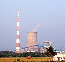
Vijayawada Thermal Power Station (VTPS), Ibrahimpatnam
Ibrahimpatnam
Interactive map
India Andhra Pradesh location map (current).svg
Red pog.svg
Ibrahimpatnam
Coordinates: 16°36′20″N80°22′3″E / 16.60556°N 80.36750°E / 16.60556; 80.36750
Country India
State Andhra Pradesh
District NTR
Mandal Ibrahimpatnam
Government
  TypeMunicipality
  Body Kondapalli Municipality,APCRDA
Area
[1]
  Total15.00 km2 (5.79 sq mi)
Elevation
[2]
27 m (89 ft)
Population
 (2011) [3]
  Total29,432
Time zone UTC+5:30 (IST)
PIN
521456
Telephone code +91–866

Ibrahimpatnam (known locally as IBM) is a part of Vijayawada in NTR district of the Indian state of Andhra Pradesh. It is also the mandal headquarters of Ibrahimpatnam mandal. [4] [1] The Dr Narla Tata Rao Thermal Power Station, one of the major thermal power stations of the state, is located near the town. [5] The Railway Wagon Workshop at Rayanapadu is also located very near to Ibrahimpatnam at a distance of 4 km.

Contents

Demographics

At the 2011 census, the village had a population of 29,432 (13,690 males and 15,742 females: a sex ratio of 1,150 females per 1,000 males). 3,052 children were in the age group of 0–6 years (1,514 are boys and 1,538 are girls; ratio of 1,016 per 1,000). The average literacy rate was 78.37% with 20,673 literates, significantly higher than the state average of 67.41%. [3] [6]

Transport

APSRTC bus at Ibrahimpatnam bus stop Ibrahimpatnam bus stop.jpg
APSRTC bus at Ibrahimpatnam bus stop

Kondapalli Railway Station is the nearest station to the town, located at a distance of 6 kilometres (3.7 mi) on Kazipet–Vijayawada section. It is under the administration of the Vijayawada railway division of South Central Railway zone. [7] NH 65 passes through the town, which connects Vijayawada and Hyderabad. APSRTC operates city buses from Ibrahimpatnam to various parts of the city. APSRTC City Bus Routes

Route NumberStartEndVia
1kIbrahimpatnamKankipaduGollapuri, City Terminal,Governorpet,M.G Road, Libbipet, Benz circle, Patamata, Poranki, Ganur
144KondapalliAuto NagarIbrahimpatam,Gollapuri,City Terminal,Governorpet,M.G Road, Libbipet, Benz circle, Patamata
145KondapalliNidamanuruIbrahimpatnam, Gollapuri,City Terminal , Maruthinagar, gunadala, Ramavarapadu, Nidamanuru,
145GKondapalli Railway StationGannavaramKondapalli Railway Station, City Terminal, Gunadala, Ramavarapadu, Prasadampadu, Enkepadu, Nidamanuru, Kesarapalli, Gannavaram
150KondapalliKankipaduIbrahimpatam,Gollapuri,City Terminal,Governorpet,M.G Road, Libbipet, Benz circle, Patamata, Tadigadapa,Penamaluru
188Kondapalli Railway StationGannavaramKondapalli Railway Station, Ibrahim patnam, City Terminal,Gunadala, Ramavarappadu, Gannavaram Centre Bus Stop
200Kondapalli KhillaCity TerminalKondapalli Railway Station, Ibrahim patnam, City Terminal

Education

Primary and secondary school education are provideded by government, aided and private schools, under the School Education Department of the state. [8] The medium of instruction in schools is English and Telugu.

See also

Related Research Articles

<span class="mw-page-title-main">Mangalagiri</span> Municipal Corporation in Andhra Pradesh, India

Mangalagiri is a major Sub-urban of Vijayawada in Guntur district of Indian state of Andhra Pradesh. The town is a part of Mangalagiri Tadepalli Municipal Corporation and part of Tenali revenue division. It and a part of Andhra Pradesh Capital Region. It is situated on National Highway 16 between Vijayawada and Guntur.

<span class="mw-page-title-main">Krishna district</span> District in Andhra Pradesh, India

Krishna district is a district in the coastal Andhra Region in Indian state of Andhra Pradesh, with Machilipatnam as its administrative headquarters. It is surrounded on the East by Bay of Bengal, West by Guntur, Bapatla and North by Eluru and NTR districts and South again by Bay of Bengal. In 2022 Krishna district was divided into Krishna and NTR districts.

<span class="mw-page-title-main">Vijayawada</span> Metropolis in Andhra Pradesh, India

Vijayawada, formerly known as Bezawada, is the second largest city in the Indian state of Andhra Pradesh. It is located on the banks of the Krishna River surrounded by the hills of the Eastern Ghats, known as the Indrakeeladri Hills. The city is home to the important Hindu shrine of Kanaka Durga Temple. It geographically lies on the center spot of Andhra Pradesh. The city has been described as the commercial, political, cultural and educational capital of Andhra Pradesh. It is the administrative headquarters of NTR district. The Prakasam Barrage across the Krishna River connects the NTR and Guntur districts.

<span class="mw-page-title-main">Gannavaram, Vijayawada</span> Suburb in Krishna, Andhra Pradesh, India

Gannavaram is a suburb of Vijayawada in Krishna district of the Indian state of Andhra Pradesh. It is also the mandal headquarters of Gannavaram mandal which is administered under Gudivada revenue division. It is a major suburb of Vijayawada in the North East side.Vijayawada International Airport, Medha IT Park, IT companies like HCL Tech and TechMahindra are located here.

<span class="mw-page-title-main">Nuzvid</span> City in Andhra Pradesh, India

Nuzvid is a city in Eluru district of the Indian state of Andhra Pradesh. It serves as the administrative headquarters for Nuzvid mandal and Nuzvid revenue division.

<span class="mw-page-title-main">Narsipatnam</span> City in Andhra Pradesh, India

Narsipatnam is a census town in Anakapalle district of the Indian state of Andhra Pradesh. It was upgraded from a gram panchayat into municipality in 2012. The town is spread over an area of 42 km2 (16 sq mi) The resting place of the revolutionary Indian freedom fighter Alluri Sitarama Raju is located in Krishna Devi Peta village of From Narsipatnam to labasingi Village 30 kms only.. labasingi most popular winter tourism place..so many Tourists enjoy -2 degree's temparature there.. Narsipatnam town is 43 km away from Tuni. And it is 72 km away from Visakhapatnam.

<span class="mw-page-title-main">Repalle</span> Town in Andhra Pradesh, India

Repalle is a town in Bapatla district of the Indian state of Andhra Pradesh. The town is one of the 12 municipalities in Bapatla district and the headquarters of Repalle mandal under the administration of Repalle revenue division. It is situated near Krishna River in the Coastal Andhra region of the state.

<span class="mw-page-title-main">Kondapalli</span> Suburb in NTR district, Andhra Pradesh, India

Kondapalli is an industrial and residential hub located in western part of Vijayawada in the Indian state of Andhra Pradesh. Dr Narla Tata Rao Thermal Power Station, one of the major Thermal Power stations of the state is located in between Ibrahimpatnam and Kondapalli. It is home for many industries like Andhra Pradesh Heavy Machinery & Engineering Limited (APHMEL), BPCL, HPCL, IOC, Reliance Industries, Lanco Infratech are located here. Kondapalli Toys are very famous in the state. Kondapalli Fort, also known as Kondapalli Kota, is located towards west of Kondapalli. The closest locality to Kondapalli is Ibrahimpatnam.

Vuyyuru is a town in Krishna district of the Indian state of Andhra Pradesh. It is a Nagar panchayat and the headquarters of Vuyyuru Mandal. It is emerging as neighbourhood of Vijayawada, India situated 30 km away.

Kankipadu is a suburb of Vijayawada and a in Krishna District of the Indian state of Andhra Pradesh. It is also the mandal headquarters of Kankipadu mandal in Vuyyuru revenue division.

Tiruvuru is a town in NTR district of the Indian state of Andhra Pradesh. It is a Municipality in Tiruvuru mandal of Tiruvuru revenue division.

<span class="mw-page-title-main">Narasannapeta</span> Census Town in Andhra Pradesh, India

Narasannapeta is a census town in Srikakulam district of the Indian state of Andhra Pradesh. It is the mandal headquarters of Narasannapeta mandal in Srikakulam revenue division. 43 villages are there under the administrative division of Narasannapeta.

<span class="mw-page-title-main">Pathapatnam</span> Place in Andhra Pradesh, India

Pathapatnam is a town in Srikakulam district of the Indian state of Andhra Pradesh. It is located in Pathapatnam mandal of Palakonda revenue division. Pathapatnam is located on the border of Srikakulam district of Andhra Pradesh and Gajapati district of Odisha. Parlakhemundi, the headquarters of Gajapati District, can be considered as twin town of Pathapatnam because of its close proximity. It is located around 65 km from srikakulam. It was the old capital of Paralakhemundi Gajapati Maharajah of his erstwhile kingdom.

<span class="mw-page-title-main">Tadepalle, Vijayawada</span> Municipal Corporation in Andhra Pradesh, India

Tadepalle is a major residential Area of the Vijayawada in Guntur district of Indian state of Andhra Pradesh. It is a major south sub urban of Vijayawada and a part of Vijayawada metropolitan area and Andhra Pradesh Capital Region. It is situated on National Highway 16 between Vijayawada and Guntur.

Mulapadu is a village in NTR district of the Indian state of Andhra Pradesh. It is located in Ibrahimpatnam mandal under Vijayawada revenue division.

Chilakaluripet is a city in Palnadu district of the Indian state of Andhra Pradesh. It is the Mandal headquarters of Chilakaluripet Mandal in Narasaraopet Revenue Division.

<span class="mw-page-title-main">Guntupalli, NTR district</span> Census Town in Andhra Pradesh, India

Guntupalli is located in western part of Vijayawada in the Indian state of Andhra Pradesh. It is a Rural area falls under Ibrahimpatnam mandal in Vijayawada revenue division of NTR district. Guntupalli Railway Wagon Workshop is located here. There is a proposal to merge this village into Vijayawada Municipal Corporation (VMC) to form a Greater Vijayawada Municipal Corporation.

<span class="mw-page-title-main">Dr. Narla Tata Rao Thermal Power Station</span> Building in India

Dr. Narla Tata Rao Thermal Power Station or Vijayawada Thermal Power Plant is located at Vijayawada in Andhra Pradesh. It is named after, Narla Tata Rao, the erstwhile chairman of the Andhra Pradesh State Electricity board. The power plant is one of the coal-based power plants of APGENCO. It is well placed between Ibrahimpatnam and Kondapalli villages.

Ibrahimpatnam mandal is one of the 20 mandals that constitute the NTR district of the State of Andhra Pradesh in India. It is under the administration of the Vijayawada revenue division and the mandal headquarters are located at Ibrahimpatnam town. The mandal is located on the banks of Krishna River and is bounded by Kanchikacherla, Veerullapadu, G. Konduru and Vijayawada (rural) mandals. The mandal is also a part of the Andhra Pradesh Capital Region under the jurisdiction of APCRDA.

<span class="mw-page-title-main">NTR district</span> District in Andhra Pradesh, India

NTR district is a district in coastal Andhra Region in the Indian state of Andhra Pradesh. The district headquarters is located at Vijayawada. The district is named after former Chief Minister of Andhra Pradesh N. T. Rama Rao. The district shares boundaries with Guntur, Palnadu, Krishna, Eluru, Khammam and Suryapet districts

References

  1. 1 2 "District Census Handbook - Krishna" (PDF). Census of India. pp. 16–17, 48. Retrieved 18 January 2015.
  2. "Elevation". Veloroutes. Retrieved 16 September 2014.
  3. 1 2 "Census 2011". The Registrar General & Census Commissioner, India. Retrieved 15 September 2014.
  4. "Krishna District Mandals" (PDF). Census of India. pp. 492, 526. Retrieved 21 January 2015.
  5. "Dr. Narla Tata Rao Thermal Power Station". Andhra Pradesh Generation Corporation Limited. Archived from the original on 14 January 2015. Retrieved 14 January 2015.
  6. "Literacy of AP (Census 2011)" (PDF). Official Portal of Andhra Pradesh Government. p. 43. Archived from the original (PDF) on 14 July 2014. Retrieved 16 September 2014.
  7. "Overview of Kondapalli Station". indiarailinfo. Retrieved 13 January 2015.
  8. "School Education Department" (PDF). School Education Department, Government of Andhra Pradesh. Archived from the original (PDF) on 27 December 2015. Retrieved 7 November 2016.