
Chittoor is a city and district headquarters in Chittoor district of the Indian state of Andhra Pradesh. It is also the mandal and divisional headquarters of Chittoor mandal and Chittoor revenue division respectively. The city has a population of 153,756 and that of the agglomeration is 175,647.

Kurnool is a city in the state of Andhra Pradesh, India. It formerly served as the capital of Andhra State (1953–1956). And is probably going to serve as the judicial capital of Andhra Pradesh in 2024. The city is often referred to as "The Gateway of Rayalaseema". Kurnool is also known as The City of Gem Stones. It also serves as the district headquarters of its Kurnool district. As of 2011 census, it is the fifth most populous city in the state with a population of 484,327. It is located on the banks of the Tungabhadra river. Although the area has been inhabited for thousands of years, modern Kurnool was founded in the 16th century CE with the construction of the Konda Reddy Fort.

Banaganapalli is a town in the state of Andhra Pradesh, India. It lies in Nandyal district, 38 km west of the city of Nandyal. Banaganapalli is famous for its mangoes and has a cultivar, Banaganapalli, named after it. Between 1790 and 1948, Banaganapalli was the capital of the princely state of the same name, Banganapalle State.
Yemmiganur is a town in Kurnool district of the Indian state of Andhra Pradesh. It is located in Yemmiganur mandal of Adoni revenue division.
Kurnool district is one of the eight districts in the Rayalaseema region of the Indian state of Andhra Pradesh after the districts are reorganised in April 2022. It is located in the north western part of the state and is bounded by Nandyal district in the east, Anantapur district in the south, Raichur district of Karnataka in the northwest, Bellary district of Karnataka in the west, and Jogulamba Gadwal district of Telangana in the north. It has a population of 2,271,686 based on the 2011 census. The city of Kurnool is the headquarters of the district.
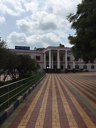
Nandyal is a city and District headquarters of Nandyal district of the Indian state of Andhra Pradesh. It is a municipality and the headquarters of Nandyal mandal in Nandyal revenue division.

Proddatur (1915) is a city in the YSR Kadapa District of Andhra Pradesh, located on the banks of the Penna River. The city is a municipality, and also the mandal headquarters of Proddatur mandal. It is the second-largest town in former Kadapa District. It is the oldest municipality which formed before Independence.
Markapuram is a town in Prakasam district of the Indian state of Andhra Pradesh. It is a municipality and is the headquarters of Markapuram mandal in Markapuram revenue division. Markapuram is notable for the Chennakesava Swamy Temple, built by King Sri Krishnadevaraya. During Ratha Yatra there occurs a popular carnival; the town is also famous for Chenna Kesavaswamy on the day of Rathsapthami, which is attended by thousands of people coming from different parts of the state. It is the second-largest town in Prakasam district after Ongole and it is the main place within West Prakasam district to avail all facilities.
Narasaraopet is a city and district headquarters of Palnadu District of the Indian state of Andhra Pradesh. The town is a municipality and mandal headquarters of Narasaraopet mandal and Headquarters of Narasaraopet revenue division. The town also is the seat of the court of Additional District Judge. Narasaraopet acts as a melting point for the Palnadu and Delta regions of the district. The town is also referred as the 'Gateway of Palnadu'. The main offices of Nagarjuna Sagar Jawahar Canal Operation & Maintenance Lingamguntla Circle are located in this town. Also it is considered as holy place because it is the birth place of panguluri prasad

Srisailam is a census town in Nandyal district of the Indian state of Andhra Pradesh. It is the mandal headquarters of Srisailam mandal in Atmakur revenue division. It is located about 160 kilometres (99 mi) from the district headquarters Nandyal, 180 kilometres (112 mi) from Kurnool, and it is located about 264 kilometres (164 mi) from Vijayawada. The town is famous for Mallikarjuna Jyotirlinga Temple and is one of the holy pilgrimage sites for Saivism and Shaktism sects of Hinduism. The town is classified as both Jyotirlinga and Shakti Peetha.

Tadipatri or Tadpatri is a city in Anantapur district of the Indian state of Andhra Pradesh at the border of Kurnool district and Kadapa district. It is the mandal headquarters of Tadipatri mandal in Anantapur revenue division. The Chintala Venkataramana Temple is located on a five-acre site in Tadipatri. The Bugga Ramalingeswara Temple is located one kilometer from the town, overlooking the Penna River.

Yerraguntla is a town and Nagar Panchayat in YSR Kadapa District. It is an industrial area in YSR Kadapa district, Andhra Pradesh. It is located in Yerraguntla mandal of Kadapa revenue division.

Mydukur is a Municipality in YSR Kadapa district of the Indian state of Andhra Pradesh. It is located in Mydukur mandal of Badvel revenue division. Mydukur is located on Main Junction of NH-40 and NH-67. It is a junction point for Kurnool, Kadapa, Proddatur, Markapur, and Nellore Highways.
Giddaluru is a town in the Prakasam district of the Indian state of Andhra Pradesh. It is the mandal headquarters of the Giddaluru mandal in Markapur revenue division. It was part of kurnool district till 1969 later it was merged into Prakasam district in 1970. Till 2008 it was under Nandyal parliament segment after delimitation it was moved to Ongole MP segment. Giddalur is also known as "3 zilla la muddu bidda " because during the Britishers rule it was in kadapa district later moved to kurnool then in 1970 merged in prakasam district. Giddalur is the only constituency in coastal districts which has Rayalseema culture,slang and traditions. Giddalur town has good transport connectivity to Nandyal, Markapur, Podili, Ongole, Kurnool, Kadapa.

Dhone or Dronachalam is a town in Nandyal district of the Indian state of Andhra Pradesh. It is a municipality located in Dhone mandal. And it is the head quarters of Dhone revenue division.

Allagadda is a town in Nandyal district of the Indian state of Andhra Pradesh. It is located in Nandyal Revenue division. The town is located at 15°08′00″N78°31′00″E.

Koilakuntla is a town in Nandyal district of the Indian state of Andhra Pradesh. It is Head quarter of Koilakuntla mandal. in Dhone revenue division

Atmakur is a town in the Nandyal district of Andhra Pradesh, India.

Andhra Pradesh lies between 12°41' and 19.07°N latitude and 77° and 84°40'E longitude, and is bordered by Telangana to the north and west, Chhattisgarh to the north-west, Orissa to the north, the Bay of Bengal to the east, Tamil Nadu to the south and Karnataka to the southwest and west. Andhra Pradesh has a coastline of around 974 km, which gives it the second longest coastline in the nation. Two major rivers, the Godavari and the Krishna run across the state. A small enclave 12 sq mi (30 km²), the Yanam district of Puducherry, lies in the Godavari Delta in the north east of the state. The state includes the eastern part of Deccan plateau as well as a considerable part of the Eastern Ghats.

Nandyal district is a district in the Indian state of Andhra Pradesh with Nandyal as its administrative headquarters, it was formed on 4 April 2022 to become one of the resultant 26 districts. It is part of the Rayalaseema region. The district consists of Nandyal revenue division and a newly formed Dhone revenue division and Atmakur revenue division from Kurnool district.


