Nellore is a city located on the banks of Penna River, in Nellore district of Andhra Pradesh, India. It serves as the headquarters of the district, as well as Nellore mandal and Nellore revenue division. It is the fourth most populous city in the state. It is at a distance of 279 kilometres (173 mi) from Vijayawada, 660 kilometres (410 mi) from Visakhapatnam, 455 kilometres (283 mi) from Hyderabad and about 170 km (110 mi) north of Chennai, Tamil Nadu and also about 380 km (240 mi) east-northeast of Bangalore, Karnataka. It is the administrative headquarters of Nellore District.

Anantapur, officially Anantapuramu, is a city in Anantapur district of the Indian state of Andhra Pradesh. It is the mandal headquarters of Anantapuru mandal and also the divisional headquarters of Anantapur revenue division. The city is located on National Highway. It was also the headquarters of the Datta Mandalam in 1799. It was also a position of strategic importance for the British Indian Army during the Second World War. The GDP of Anantapur City is $ 1.728 Billion.

Kurnool is a city in the state of Andhra Pradesh, India. It formerly served as the capital of Andhra State (1953–1956). The city is often referred to as "The Gateway of Rayalaseema". Kurnool is also famous for Diamond hunting as diamonds can be found in the barren land of Kurnool after the top layers of soil are washed away by the monsoon rains. It also serves as the district headquarters of its Kurnool district. As of 2011 census, it is the fifth most populous city in the state with a population of 484,327. It is located on the banks of the Tungabhadra river. Although the area has been inhabited for thousands of years, modern Kurnool was founded in the 16th century CE with the construction of the Konda Reddy Fort.
Yemmiganur is a town in Kurnool district of the Indian state of Andhra Pradesh. It is located in Yemmiganur mandal of Adoni revenue division.
Kurnool district is one of the eight districts in the Rayalaseema region of the Indian state of Andhra Pradesh after the districts are reorganised in April 2022. It is located in the north western part of the state and is bounded by Nandyal district in the east, Anantapur district in the south, Raichur district of Karnataka in the northwest, Bellary district of Karnataka in the west, and Jogulamba Gadwal district of Telangana in the north. It has a population of 2,271,686 based on the 2011 census. The city of Kurnool is the headquarters of the district. Konda Reddy Fort, Mantralayam and Orvakal Rock Garden, Kurnool are tourist places of interest in the district.

Prakasamdistrict is one of the twelve districts in the coastal Andhra region of the Indian state of Andhra Pradesh. It was formed in 1970 and reorganised on 4 April 2022. The headquarters of the district is Ongole. It is located on the western shore of Bay of Bengal and is bounded by Bapatla district and Palnadu districts in the north, Nandyal district in the west, Kadapa and Nellore districts in the south. A part of north west region also borders with Nagarkurnool district of Telangana. It is the largest district in the state with an area of 14,322 km2 (5,530 sq mi) and had a population of 22,88,026 as per 2011 Census of India.

Kadapa is a city in the southern part of Andhra Pradesh, India. It is located in the Rayalaseema region, and is the district headquarters of YSR Kadapa district. As of the 2022 Census of India, the city had a population of 466,000, a 2.42% increase from 2021. It is located 8 kilometres (5.0 mi) south of the Penna River. The city is surrounded on three sides by the Nallamala and Palkonda Hills lying on the tectonic landscape between the Eastern and Western ghats. Black and red ferrous soils occupy the region. The city is nicknamed "Gadapa" ('threshold') since it is the gateway from the west to the hills of Tirumala.

Proddatur (1915) is a city in the YSR Kadapa District of Andhra Pradesh, located on the banks of the Penna River. The city is a municipality, and also the mandal headquarters of Proddatur mandal. It is the second-largest town in former Kadapa District. It is the oldest municipality which formed before Independence.

Markapuram is a town in Prakasam district of the Indian state of Andhra Pradesh. It is a municipality and is the headquarters of Markapuram Municipality in Markapuram revenue division. Markapuram is notable for the Chennakesava Swamy Temple, built by King Sri Krishnadevaraya. During Ratha Yatra there occurs a popular carnival; the town is also famous for Chenna Kesavaswamy on the day of Rathsapthami, which is attended by thousands of people coming from different parts of the state. It is the second-largest town in Prakasam district after Ongole and it is the main place within West Prakasam district to avail all facilities.
Narasaraopeta is a city and district headquarters of Palnadu District of the Indian state of Andhra Pradesh. The town is a municipality and mandal headquarters of Narasaraopet mandal and Headquarters of Narasaraopet revenue division. The town also is the seat of the court of Additional District Judge. Kotappakonda in Narasaraopeta was famous for Kotappakonda Tirunalla. The town is also referred as the 'Gateway of Palnadu'. The main offices of Nagarjuna Sagar Jawahar Canal Operation & Maintenance Lingamguntla Circle are located in this town. Also it is considered as holy place.

Nidadavolu is a town in East Godavari district of the Indian state of Andhra Pradesh. It is a municipality and the mandal headquarters of Nidadavole mandal in Kovvur revenue division.

Rayadurgam is a town in Anantapur District in the Indian state of Andhra Pradesh. It is governed by a municipal council. Rayadurgam is known for its production of textile goods and textile manufacturing industry. Rayadurgam is in Southern India about 451.6 km (280.6 mi) from Hyderabad. Rayadurgam is now slowly developing with proper transportation, modern amenities. Rayadurgam is well connected with other cities in Andhra Pradesh and Karnataka through well infrastructure of NH 544DD Highway. The nearest airport is Ballari Airport in Karnataka followed by Kurnool, Puttaparthi and Bengaluru. Rayadurgam also has a train station with major stations nearby such as Ballari, Guntakal, Gooty & Anantapur.

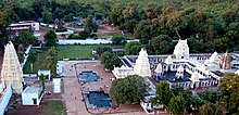
Srisailam is a census town in Nandyal district of the Indian state of Andhra Pradesh. It is the mandal headquarters of Srisailam mandal in Atmakur revenue division. It is located about 160 kilometres (99 mi) from the district headquarters Nandyal, 180 kilometres (112 mi) from Kurnool, and it is located about 264 kilometres (164 mi) from Vijayawada. The town is famous for the Mallikarjuna Jyotirlinga Temple and is one of the holy pilgrimage sites for the Shaivism and Shaktism sects of Hinduism. The town is classified as both a Jyotirlinga and a Shakta pitha.

Tadipatri is a city in Anantapur district of the Indian state of Andhra Pradesh at the border of Nandyala district and Kadapa district. It is a Selection Grade Municipality City Council. Tadipatri is a headquarters of Tadipatri mandal in Anantapur revenue division. The Chintala Venkataramana Temple is located on a five-acre site in Tadipatri. The Bugga Ramalingeswara Temple is located one kilometer from the city, overlooking the Penna River.

Yerraguntla is a town and Nagar Panchayat in YSR Kadapa District. It is an industrial area in YSR Kadapa district, Andhra Pradesh. It is located in Yerraguntla mandal of Kadapa revenue division.
Nandigama is a town in NTR district of the Indian state of Andhra Pradesh. It is a Municipality and also the headquarters of Nandigama mandal in Nandigama revenue division.
Nandikotkur is a municipality and capital of Nandikotkur mandal in Nandyal district of Andhra Pradesh, India.

Dhone or Dronachalam is a town in Nandyal district of the Indian state of Andhra Pradesh. It is a municipality located in Dhone mandal, and it is the head quarters of Dhone revenue division.

Allagadda is a town in Nandyal district of the Indian state of Andhra Pradesh. It is located in Nandyal Revenue division. The town is located at 15°08′00″N78°31′00″E.

Atmakur is a town and revenue division in the Nandyal district of Andhra Pradesh, India.

