Tadipatri | |
|---|---|
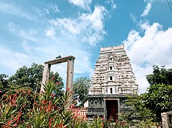 Tadipatri - Sri Chintala Venkataramana Temple | |
| Nickname: Tadpatri | |
 Tadipatri Location in Andhra Pradesh, India | |
| Coordinates: 14°55′N78°01′E / 14.92°N 78.02°E | |
| Country | India |
| State | Andhra Pradesh |
| District | Anantapur |
| Area | |
• Total | 7.46 km2 (2.88 sq mi) |
| • Rank | 28 |
| Elevation | 229 m (751 ft) |
| Population (2021) [1] | |
• Total | 178,171 |
| • Rank | 28 |
| • Density | 24,000/km2 (62,000/sq mi) |
| Languages | |
| • Official | Telugu |
| Time zone | UTC+5:30 (IST) |
| PIN | 515411 |
| ISO 3166 code | IN-AP |
| Vehicle registration | AP - 02 |
| Website | tadipatri |
Tadipatri is a city in Anantapur district of the Indian state of Andhra Pradesh at the border of Nandyala district and Kadapa district. It is a Selection Grade Municipality City Council. Tadipatri is a headquarters of Tadipatri mandal in Anantapur revenue division. [2] The Chintala Venkataramana Temple is located on a five-acre site in Tadipatri. The Bugga Ramalingeswara Temple is located one kilometer from the city, overlooking the Penna River. [3]


