Kalyandurg

Last updated

Kalyandurg
KalyanadurgHills.jpg
Akkammagari Konda and surrounding Hills.
India Andhra Pradesh location map (current).svg
Red pog.svg
Kalyandurg
Location in Andhra Pradesh, India
Coordinates: 14°33′00″N77°06′00″E / 14.5500°N 77.1000°E / 14.5500; 77.1000
Country India
State Andhra Pradesh
District Anantapur
Government
   MLA K. V. Ushashri charan
Area
[1]
  Total34.92 km2 (13.48 sq mi)
Elevation
656 m (2,152 ft)
Population
 (2011) [2]
  Total32,328
  Density930/km2 (2,400/sq mi)
Languages
  Official Telugu
Time zone UTC+5:30 (IST)
Website Kalyandurg Municipality

Kalyandurg is a town in Anantapur district of the Indian state of Andhra Pradesh. It is the headquarters for Kalyandurg mandal and Kalyandurg revenue division. [3] [4] The discovery of diamond-bearing Kimberlites in Kalyandurg area, is one of the clusters that has been discovered. [5]

Contents

History

Kalyandurg was under the rule of Sri Krishnadevaraya and was a part of Vijayanagara Empire.

As per The imperial gazetteer of India, Rayadurg, Chitradurga and Kalyandurg are the three important forts that were ruled by Boya Palegars. The name Kalyandurg came from Boya Kalyanappa, a Palaegar in the 16th century. Kalyandurg was very turbulent during the Vijayanagar rule.

Kalyandurg taluk was formed in December 1893 by the British out of portions of Dharmavaram and of the Rayadurg taluk of Bellary. In March 2012 Kalyandurg became a municipality.

Kalyandurg was a taluk of Anantapur district in Madras province which was earlier a part of Dharmavaram that was separated in 1893. [6]

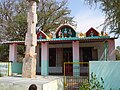
Sri Subrahmanyeswara Swamy temple is located at the heart of the town. This temple was built around the 16th century.

Anantapur district is replete with Megalithic remains. [7] In the vicinity of Kalyanadurg, several hundred megalithic monuments, such as dolemnoid cists and cairn circles are situated at the foothills and the slopes of the Akkamma Vari hills. Another large group of cairn circles is 2 km north of Akkamma Gari Konda. Similar remains are located at Mudigallu, a village about 5 km easterly to Kalyandurg, and Muthalabanda village, 2  km north east of town, and Gallapalli situated towards Rayadurgam. [8]

Geography

Kalyandurg is located at 14°33′00″N77°06′00″E / 14.5500°N 77.1000°E / 14.5500; 77.1000 . [9] It has an average elevation of 591 metres (1942 ft).

Demographics

As of 2011 Census of India, Kalyandurg had a population of 32,328. The population constituted 16,036 males and 16,292 females — a sex ratio of 1016 females per 1000 males. 3,404 children are in the age group of 0–6 years, of which 1,760 are boys and 1,644 are girls — a ratio of 979 per 1000. The average literacy rate stands at 74.14% with 21,443 literates, significantly higher than the state average of 67.41%. [2] [10]

Governance

Civic administration

The municipality is spread over an area of 15.895 km2 (6.137 sq mi). It has an expenditure of 229.29 crore (US$29 million) and generates an annual income of 222.87 crore (US$28 million). [11] The municipal body oversees the supply of water with 70 litres per capita per day, in the form 453 public taps and 66 bore–wells. Its other services include maintenance of community halls, secondary and elementary schools and 13.45 km2 (5.19 sq mi) of roads, maternity and child health center such as the Government Hospital, RDT Hospital, and others. [12]

Politics

Kalyandurg (Assembly constituency) is one of 14 constituencies in Anantapur district, representing Andhra Pradesh Legislative Assembly.K. V. Ushashri Charan [13] of YSR Congress Party is the present MLA representing Kalyandurg (Assembly constituency). [14]

Members of Legislative Assembly

YearMemberPolitical party
1952 Narayanappa Sanda Indian National Congress
1952 Santhappa Indian National Congress
1967T.C. Mareppa Independent politician
1972 M. Lakshmi Devi Indian National Congress
1978 Hindi Narasappa Janata Party
1983T.C. Mareppa Telugu Desam Party
1985Pakeerappa Communist Party of India
1989 M Lakshmi Devi Indian National Congress
1994 B C Govindappa Telugu Desam Party
1999 A Saradamba Telugu Desam Party
2004 B C Govindappa Telugu Desam Party
2009 Raghuveera Reddy Indian National Congress
2014 U Hanumantaraya Chowdary Telugu Desam Party
2019 K.V.Ushashri Charan YSR Congress Party

Education

The primary and secondary school education is imparted by government, aided and private schools, under the School Education Department of the state. [15] [16] The medium of instruction followed by different schools are English and Telugu.

Transport

The Kalyandurg railway station is under the jurisdiction of Bangalore railway division of South Western Railway Zone [17]

More pictures

See also

Related Research Articles

<span class="mw-page-title-main">Anantapur</span> City in Andhra Pradesh, India

Anantapur, officially Anantapuramu, is a city in Anantapur district of the Indian state of Andhra Pradesh. It is the mandal headquarters of Anantapuru mandal and also the divisional headquarters of Anantapur revenue division. The city is located on National Highway. It was also the headquarters of the Datta Mandalam in 1799. It was also a position of strategic importance for the British Indian Army during the Second World War.

Dharmavaram is a city in Sri Sathya Sai District of the Andhra Pradesh state of Indian country. It is mandal and divisional headquarters of Dharmavaram mandal and Dharmavaram revenue division respectively. The city is known for its handloom silk sarees. The city is renowned for cotton, silk weaving industries and leather puppets. The city is called as Silk city of Andhra Pradesh. Dharmavaram is famous for Handloom Weavers, Saree Designs, Jacquard designs, Silk Extraction from Silkworm Cacoons, Dyeing and it is fully populated by maximum weavers and by developing technology makes changes by producing various types of machine equipment emerging for weavers to weave quickly than the past decades and quality production was happening now and the production was famous for Sarees.

<span class="mw-page-title-main">Adoni</span> City in Andhra Pradesh, India

Adoni is a city in the Kurnool district in the Indian state of Andhra Pradesh. It is a municipality and the headquarters of Adoni mandal, administered under the Adoni Revenue Division. In the 2011 census of India, Adoni had a population of 166,344, making it the 16th most populous town in the state with an urban agglomeration population of 184,625.

<span class="mw-page-title-main">Gooty</span> Town in Andhra Pradesh, India

Gooty is a town in Anantapur district of the Indian state of Andhra Pradesh. It is the headquarters of Gooty mandal in Anantapur revenue division. The town is renowned for the Gooty hill fort.

<span class="mw-page-title-main">Vizianagaram district</span> District of Andhra Pradesh in India

Vizianagaram district is one of the six districts in the Uttarandhra region of the Indian state of Andhra Pradesh with its headquarters located at Vizianagaram. The district was once the part of ancient Kalinga.Saripilli Dibbilingeswara temple, Jayathi Mallikarjuna Temple are the finest examples of ancient Eastern Ganga Dynasty built monuments in the district. The district is bounded on the east by the district of Srikakulam, north by Parvathipuram Manyam south by Visakhapatnam, Anakapalli, southeast by the Bay of Bengal, and west by Alluri Sitharama Raju district. It was formed on 1 June 1979, with some parts carved from the neighbouring districts of Srikakulam and Visakhapatnam. The district is named after the princely state of Vizianagaram. In 2011, it was the least populous district in Andhra Pradesh.

<span class="mw-page-title-main">Anantapur district</span> District of Andhra Pradesh in India

Anantapur district officially: Anantapuramu district is one of the eight districts in the Rayalaseema region of the Indian state of Andhra Pradesh. The district headquarters is located in Anantapur city. It is one of the driest places in South India. In the year 2022, as part of re-organisation of districts, Sri Sathya Sai district was carved out.

<span class="mw-page-title-main">Kurnool district</span> District of Andhra Pradesh, India

Kurnool district is one of the eight districts in the Rayalaseema region of the Indian state of Andhra Pradesh after the districts are reorganised in April 2022. It is located in the north western part of the state and is bounded by Nandyal district in the east, Anantapur district in the south, Raichur district of Karnataka in the northwest, Bellary district of Karnataka in the west, and Jogulamba Gadwal district of Telangana in the north. It has a population of 2,271,686 based on the 2011 census. The city of Kurnool is the headquarters of the district.

<span class="mw-page-title-main">Srikakulam district</span> District of Andhra Pradesh in India

Srikakulam district is one of the twenty-six districts of the Indian state of Andhra Pradesh, located in the Uttarandhra region of the state, with its headquarters located at Srikakulam. It is one of the six districts, located in the extreme northeastern direction of the state. It was formerly known as Chicacole, and was under Ganjam district till 1936 April 1, then merged under Vizagapatam district. Srikakulam district forms the core area of Kalinga where most of its historical capitals like Kalinganagari, pithunda, Dantapuram are located.

Guntakal is a City in Anantapur district of the Indian state of Andhra Pradesh. It is the headquarters of Guntakal mandal and Guntakal revenue division.It is also the headquarters of the Guntakal Railway Division in South Central Railway.

<span class="mw-page-title-main">Tadepalligudem</span> City in Andhra Pradesh, India

Tadepalligudem is a city in West Godavari district of the Indian state of Andhra Pradesh. It is a Selection Grade municipality and the mandal headquarters of Tadepalligudem mandal and Tadepalligudem Revenue Division.

Kadiri is a major city in Sri Sathya Sai District the Indian state of Andhra Pradesh. It is a Special Grade Municipal City Council and headquarters of Kadiri Mandal and Kadiri Revenue Division. Kadiri Taluka ('Tehsil') was the largest taluk in the state of Andhra Pradesh when there was taluka system in Andhra Pradesh Kadiri is known for its jasmine and saffron flowers. Kadiri saffron is widely sold in Andhra and Karnataka. The Sri Lakshmi Narasimhaswamy Temple is reminiscent of Kadiri to the people of Karnataka, Telangana And Tamil Nadu. The name of Kadiri has also some interesting past. The habitation was initially named as Khadripuram as ‘khadara’ plants were largely found in the surrounding forests and Khadri has later transformed as Kadiri.

<span class="mw-page-title-main">Hindupur</span> City in Andhra Pradesh, India

Hindupuram is a city in Sri Sathya Sai district of the Indian state of Andhra Pradesh. It is located to the edge of the Andhra–Karnataka border and is the headquarters of Hindupuram mandalam. Hindupuram is the biggest Parliamentary Constituency in the newly formed District Sri Sathya Sai. It is located about 67 km from district headquarters Puttaparthi, 100 km from Bengaluru the capital of Karnataka, 95 km From Kadiri.

<span class="mw-page-title-main">Rayadurgam</span> Town in Andhra Pradesh, India

Rayadurgam is a town in Anantapur District in the Indian state of Andhra Pradesh. It is governed by a municipal council. Rayadurgam is known for its production of textile goods and textile manufacturing industry. Rayadurgam is in Southern India about 451.6 km (280.6 mi) from Hyderabad. Rayadurgam is now slowly developing with proper transportation, modern amenities. Rayadurgam is well connected with other cities in Andhra Pradesh and Karnataka through well infrastructure of NH 544DD Highway. The nearest airport is Ballari Airport in Karnataka followed by Kurnool, Puttaparthi and Bengaluru. Rayadurgam also has a train station with major stations nearby such as Ballari, Guntakal, Gooty & Anantapur.

<span class="mw-page-title-main">Salur</span> Town in Andhra Pradesh, India

Salur or Saluru is a municipal town and mandal headquarters in Parvathipuram Manyam district, of the Indian state of Andhra Pradesh.

<span class="mw-page-title-main">Tadipatri</span> City in Andhra Pradesh, India

Tadipatri or Tadpatri is a city in Anantapur district of the Indian state of Andhra Pradesh at the border of Kurnool district and Kadapa district. It is the mandal headquarters of Tadipatri mandal in Anantapur revenue division. The Chintala Venkataramana Temple is located on a five-acre site in Tadipatri. The Bugga Ramalingeswara Temple is located one kilometer from the town, overlooking the Penna River.

<span class="mw-page-title-main">Nagari, Andhra Pradesh</span> Town in Andhra Pradesh, India

Nagari is a town in Chittoor district of the Indian state of Andhra Pradesh. It is the mandal headquarters of Nagari mandal in Nagari revenue division.

Bommanahal is a village in Anantapur district of the Indian state of Andhra Pradesh. It is the headquarters of Bommanahal mandal in Kalyandurg revenue division.

D.Hirehal is a village in Anantapur district of the Indian state of Andhra Pradesh. It is the headquarters of D. Hirehal mandal in Kalyandurg revenue division. It is part of Rayadurg Assembly constituency.

Chennekothapalle is a village in Sri Sathya Sai district of the Indian state of Andhra Pradesh. It is the headquarters of Chennekothapalle mandal in Dharmavaram revenue division.

<span class="mw-page-title-main">Mangalagiri mandal</span> Mandal in Andhra Pradesh, India

Mangalagiri mandal is one of the 18 mandals in Guntur district of the Indian state of Andhra Pradesh. It is under the administration of Tenali revenue division and the headquarters are located at Mangalagiri town part of Mangalagiri Tadepalli Municipal Corporation. The mandal is bounded by Thullur, Tadepalle, Tadikonda, Pedakakani and Duggirala mandals and a portion of the mandal lies on the banks of Krishna River.

References

  1. "Municipalities, Municipal Corporations & UDAs" (PDF). Directorate of Town and Country Planning. Government of Andhra Pradesh. Archived from the original (PDF) on 28 January 2016. Retrieved 29 January 2016.
  2. 1 2 "Census 2011". The Registrar General & Census Commissioner, India. Retrieved 11 September 2014.
  3. "Anantapur District Mandals" (PDF). Census of India. p. 386. Retrieved 6 June 2017.
  4. "Anantapur gets two more revenue divisions". The Hindu. Anantapur. 27 June 2013. Retrieved 10 June 2015.
  5. "Discovery of diamond-bearing kimberlites in Kalyandurg area, Anantapur district, Andhra Pradesh". Indian Institute of Science, Bangalore. Retrieved 11 September 2014.
  6. Prem Loganathan. "Boyar mudiraja". The Great Boyar Valmiki Nayaka Emperors. bedar.nayaka.in. Retrieved 12 September 2014.
  7. "Archeological Survey of India". asihyd.ap.nic.in.
  8. Murty, M. L. K. (6 June 2017). Comprehensive History and Culture of Andhra Pradesh: Pre- and protohistoric Andhra Pradesh up to 500 BC. Orient Blackswan. ISBN   9788125024750 via Google Books.
  9. Kalyandurg at Fallingrain.com
  10. "Literacy of AP (Census 2011)" (PDF). Official Portal of Andhra Pradesh Government. p. 43. Archived from the original (PDF) on 14 July 2014. Retrieved 11 September 2014.
  11. "Basic Information of Municipality". Commissioner & Director of Municipal Administration. Municipal Administration & Urban Development Department, Govt. of Andhra Pradesh. Retrieved 11 September 2014.
  12. "Public services/amenities". Commissioner & Director of Municipal Administration. Municipal Administration & Urban Development Department, Govt. of Andhra Pradesh. Retrieved 11 September 2014.
  13. "Andhra Pradesh Assembly Election 2019 Results: Full Winners List". India Today. 24 May 2019.
  14. "MLA's". Official portal of Andhra Pradesh Government. Retrieved 11 September 2014.
  15. "School Education Department" (PDF). School Education Department, Government of Andhra Pradesh. Archived from the original (PDF) on 27 December 2015. Retrieved 7 November 2016.
  16. "The Department of School Education – Official AP State Government Portal | AP State Portal". www.ap.gov.in. Archived from the original on 7 November 2016. Retrieved 7 November 2016.
  17. Jayashree. "Trains to KYND/Kalyandurga Station - 2 Arrivals SWR/South Western Zone - Railway Enquiry". indiarailinfo.com.