Puttur, Andhra Pradesh

Last updated

Puttur
PutturTown.jpg
Puttur Town
India Andhra Pradesh location map (current).svg
Red pog.svg
Puttur
Location in Andhra Pradesh, India
Coordinates: 13°27′N79°33′E / 13.45°N 79.55°E / 13.45; 79.55
Country India
State Andhra Pradesh
District Tirupati
Mandal Puttur
Government
  Type Municipality
  BodyPuttur municipality
Area
[1]
  Total43.29 km2 (16.71 sq mi)
Population
 (2011) [2]
  Total54,092
  Density1,200/km2 (3,200/sq mi)
Languages
  OfficialTelugu
Time zone UTC+5:30 (IST)
PIN
517583
Telephone code+91–8577
Vehicle registration AP-03

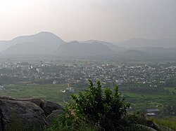
Puttur is a town in Tirupati district of the Indian state of Andhra Pradesh. It is the mandal headquarters of Puttur mandal in Tirupati revenue division. [3] [4] It is known for a traditional method of splinting/bandaging bone fractures. [5] [6] [7]

Contents

Geography

Puttur is located at 13°26′N79°33′E / 13.43°N 79.55°E / 13.43; 79.55 . [8] It has an average elevation of 144  metres (472  feet). It is located 100 km from Chennai and 40 km from Tirupati city. It falls on the Mumbai- Chennai railway route. As it is located at the Andhra Pradesh and Tamil Nadu border, people speak Telugu and Tamil in this region.

Education

Puttur serves near by 6 major mandals. Puttur consists of 10 ZPHS government Schools, 12 MPPS schools, many private schools and many junior and degree colleges along with 3 major Engineering colleges under the School Education Department of the state. [9] [10]

See also

Related Research Articles

<span class="mw-page-title-main">Chittoor</span> City in Andhra Pradesh, India

Chittoor is a city and district headquarters in Chittoor district of the Indian state of Andhra Pradesh. It is also the mandal and divisional headquarters of Chittoor mandal and Chittoor revenue division respectively. The city has a population of 153,756 and that of the agglomeration is 175,647.

<span class="mw-page-title-main">Madanapalle</span> City in Andhra Pradesh, India

Madanapalle is the largest city in Annamayya district and Rajampet Lok Sabha constituency of the Indian state of Andhra Pradesh. It is a Selection Grade Municipal City Council. Madanapalle is headquarters of Madanapalle Mandal,Madanapalle revenue division and PKM Urban Development Authority.

Kuppam is a City in Chittoor district of the Indian state of Andhra Pradesh. It is located 115.8 kilometers south-east of Bangalore, the capital city of Karnataka, and 243 kilometers west of Chennai, the capital of Tamil Nadu. It is the headquarters of Kuppam mandal in the Kuppam Revenue Division. The name "Kuppam" means a meeting place or confluence.

<span class="mw-page-title-main">Tirupati</span> City in Andhra Pradesh, India

Tirupati is a city in the Indian state of Andhra Pradesh. It is the administrative headquarters of the Tirupati district. The city is home to the important Hindu shrine of Tirumala Venkateshwara Temple and other historic temples. It is located at a distance of 150 km from Chennai, 250 km from Bangalore,406 km from Amaravati. It is one of the eight Svayam vyakta kshetras dedicated to Vishnu. Tirupati is a municipal corporation and the headquarters of Tirupati (urban) mandal, Tirupati (rural) mandal, and the Tirupati revenue division.

<span class="mw-page-title-main">Chittoor district</span> District of Andhra Pradesh in India

Chittoor district is one of the eight districts in the Rayalaseema region of the Indian state of Andhra Pradesh. It has a population of 18,72,951 according to 2011 census of India. It is a major market centre for mangoes, grains, sugarcane, and peanuts. The district headquarters is located at Chittoor.

<span class="mw-page-title-main">Nellore district</span> District of Andhra Pradesh in India

Nellore district, officially known as Sri Potti Sriramulu Nellore district in Coastal Andhra Region, is one of the 26 districts in the Indian state of Andhra Pradesh. According to the 2011 Census, the district's population was 2,469,712 of which 29.07% was urban. Its administrative headquarters are located in Nellore city. Located in the Coastal Andhra region, the district is bordered by the Bay of Bengal to the east, Kadapa district and Annamayya district to the west, Prakasam district to the north, and Tirupati district to the south.

<span class="mw-page-title-main">Tiruchanur</span> Neighborhood of Tirupati city in Andhra Pradesh, India

Tiruchanur is a suburb and neighbourhood of Tirupati and is located in Tirupati district of the Indian state of Andhra Pradesh. It is a part of Tirupati urban agglomeration. It is the mandal headquarters of Tirupati (rural) mandal. It is a religious destination for Hindu pilgrims due to the presence of Padmavathi Temple. It falls in the jurisdictional limit of Tirupati Urban Development Authority.

<span class="mw-page-title-main">Kovur, Nellore district</span> Village in Andhra Pradesh, India

Kovur is a village in Nellore district of the Indian state of Andhra Pradesh. The village is also the headquarters of the Kovur Mandal and Assembly Constituency. It is located in Kovur mandal of Nellore revenue division. It forms a part of Nellore Urban Development Authority. The poet "Thikkanna" was born in this place.

Gudur is a town in Tirupati district of the Indian state of Andhra Pradesh. It is a municipality and the headquarters of Gudur mandal and Gudur revenue division.

Narayanavanam is a census town in Tirupati district of the Indian state of Andhra Pradesh. It is the headquarters of Narayanavanam mandal in Sri Kalahasti revenue division. The town is known for Kalyana Venkateswara Temple dedicated to Lord Venkateswara and constructed in 1541 AD.

Pallipattu is a town in Tamil Nadu and a border town located between the Chittoor District of Andhra Pradesh and Tiruvallur District of Tamil Nadu. It is known for its fertile agricultural lands and the west-to-east flowing river Kusasthalai.

<span class="mw-page-title-main">Renigunta</span> Neighbourhood of Tirupati in Andhra Pradesh, India

Renigunta is a neighbourhood and suburb of Tirupati located in Tirupati district of the Indian state of Andhra Pradesh. Tirupati Airport is located in Renigunta. It is a part of Tirupati urban agglomeration. It is also the mandal headquarters of Renigunta mandal in Tirupati district. It also falls in the jurisdictional limit of Tirupati Urban Development Authority.

<span class="mw-page-title-main">Srikalahasti</span> Town in Andhra Pradesh, India

Srikalahasti is a holy town at Tirupati district in the Indian state of Andhra Pradesh. It is a municipality and the revenue division of Srikalahasti mandal and Srikalahasti revenue division. It is a part of the Tirupati Urban Development Authority, which is located on the banks of the River Swarnamukhi.

Venkatagiri is a town in Tirupati district of the Indian state of Andhra Pradesh. It is a municipality and mandals headquarters of Venkatagiri mandal. Venkatagiri's old name is "Kali Mili". It is famous for its Handloom Cotton Sarees. Venkatagiri is a place for history and handlooms. It was part of a small kingdom that was integrated into the Indian Republic.

<span class="mw-page-title-main">Pakala, Tirupati district</span> Town in Andhra Pradesh, India

Pakala is a town in Tirupati district of the Indian state of Andhra Pradesh. It is the mandal headquarters of Pakala mandal. It comes under Tirupati revenue division.

<span class="mw-page-title-main">Pileru</span> Town in Andhra Pradesh, India

Pileru is a census town in Annamayya district of Rayalaseema region of the Indian state of Andhra Pradesh. Pileru is located 197 Km North East of Bangalore, The Capital City Of Karnataka and 189 Km North West of Chennai, The Capital City Of Tamil Nadu and 464 Km South To The State Capital Amaravati .It is the mandal headquarters of Pileru mandal in Rayachoti revenue division. The name 'Pileru' means a "small river stream" or "Pilla Eru" in Telugu.

<span class="mw-page-title-main">Podili</span> Town in Andhra Pradesh, India

Podili is a Municipality Town in Prakasam district of the Indian state of Andhra Pradesh. It is the mandal headquarters of Podili mandal. Podili is also known as Prudulapuri. Before British rule its name was "Prudulapuri" meaning "Head quarters of the universe". There is purana reference to this related to Prudhu Chakravarthi.

<span class="mw-page-title-main">Orvakal</span> Village in Andhra Pradesh, India

Orvakal is a village and a Mandal Head quarter of Orvakal Mandal in Kurnool district in the state of Andhra Pradesh in India. It also part of Kurnool Urban Development Authority.

National Highway 716 is a National Highway in India. It starts from its junction with NH 16 near Chennai in Tamil Nadu and terminates at its junction with NH 40 near Kadapa in Andhra Pradesh.

<span class="mw-page-title-main">Tirupati district</span> District in Andhra Pradesh, India

Tirupati district is one of the eight districts of Rayalaseema region in the Indian state of Andhra Pradesh. The district headquarters is located at Tirupati city. This district is known for its numerous historic temples, including the Hindu shrine of Tirumala Venkateswara Temple and Sri Kalahasteeswara temple. The district is also home to Satish Dhawan Space Centre, a rocket launch centre located in Sriharikota. The river Swarnamukhi flows through Tirupati, Srikalahasti and joins the Bay of Bengal.

References

  1. "Municipalities, Municipal Corporations & UDAs" (PDF). Directorate of Town and Country Planning. Government of Andhra Pradesh. Archived from the original (PDF) on 28 January 2016. Retrieved 29 January 2016.
  2. "Census of India Search details". censusindia.gov.in. Retrieved 10 May 2015.
  3. "Tirupati District Mandals,it is situated between Tirupati and Chennai city" (PDF). Census of India. pp. 483, 515. Retrieved 19 June 2015.
  4. "District Census Handbook -Tirupati" (PDF). Census of India. pp. 22–23. Retrieved 20 January 2016.
  5. Panda, AshokKumar; Rout, Suvendu (2011). "Puttur kattu (bandage) - A traditional bone setting practice in south India". Journal of Ayurveda and Integrative Medicine. 2 (4): 174–178. doi: 10.4103/0975-9476.90766 . ISSN   0975-9476. PMC   3255447 . PMID   22253506.
  6. Umashanker, K. (5 December 2018). "Despite advances in medicine, Puttur kattu has global takers". The Hindu. ISSN   0971-751X . Retrieved 30 December 2019.
  7. Manjunath, Amrutha (September 2017). "An Andhra Pradesh family's generations-old method of treating fractures". The Caravan . Retrieved 30 December 2019.
  8. "Puttur Pin Code, Puttur , Chittoor Map , Latitude and Longitude , Andhra Pradesh". www.indiamapia.com. Retrieved 25 March 2016.
  9. "School Education Department" (PDF). School Education Department, Government of Andhra Pradesh. Archived from the original (PDF) on 27 December 2015. Retrieved 7 November 2016.
  10. "The Department of School Education - Official AP State Government Portal | AP State Portal". www.ap.gov.in. Archived from the original on 7 November 2016. Retrieved 7 November 2016.