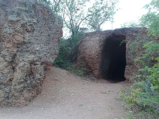
Srikakulam is a city and the headquarters of Srikakulam district in the Indian state of Andhra Pradesh. As of 2011 census, it has a population of 165,735. There are many other places of Buddhist Tourism such as Salihundam, Kalinga Patnam, Dabbaka Vaani Peta, Nagari Peta, Jagati Metta, Singupuram etc. in Srikakulam District. The Buddhist heritage site of Salihundam has some unique features. It has a beautiful star atop a stupa, rock cut massive stupas inside chaitya grihas, brick stupas with wheel pattern plan, votive stupas, inscriptions on the steps leading to the stupas and museum housing over two dozen sculpted statue and figurines of Buddha, Jain Teerthankars and other deities.
Dharmavaram is a city in Sri Sathya Sai District of the Andhra Pradesh state of Indian country. It is mandal and divisional headquarters of Dharmavaram mandal and Dharmavaram revenue division respectively. The city is known for its handloom silk sarees. The city is renowned for cotton, silk weaving industries and leather puppets. The city is called as Silk city of Andhra Pradesh. Dharmavaram is famous for Handloom Weavers, Saree Designs, Jacquard designs, Silk Extraction from Silkworm Cacoons, Dyeing and it is fully populated by maximum weavers and by developing technology makes changes by producing various types of machine equipment emerging for weavers to weave quickly than the past decades and quality production was happening now and the production was famous for Sarees.

Vizianagaram district is one of the six districts in the Uttarandhra region of the Indian state of Andhra Pradesh with its headquarters located at Vizianagaram. The district was once the part of ancient Kalinga.Saripilli Dibbilingeswara temple, Jayathi Mallikarjuna Temple are the finest examples of ancient Eastern Ganga Dynasty built monuments in the district. The district is bounded on the east by the district of Srikakulam, north by Parvathipuram Manyam south by Visakhapatnam, Anakapalli, southeast by the Bay of Bengal, and west by Alluri Sitharama Raju district. It was formed on 1 June 1979, with some parts carved from the neighbouring districts of Srikakulam and Visakhapatnam. The district is named after the princely state of Vizianagaram. In 2011, it was the least populous district in Andhra Pradesh.

Nuzvid, natively spelled Nuzividu or Nuziveedu is a city in the Eluru district of the Indian state of Andhra Pradesh. It serves as the administrative headquarters for Nuzvid mandal and Nuzvid revenue division.

Proddatur (1915) is a city in the YSR Kadapa District of Andhra Pradesh, located on the banks of the Penna River. The city is a municipality, and also the mandal headquarters of Proddatur mandal. It is the second-largest town in former Kadapa District. It is the oldest municipality which formed before Independence.

Tadepalligudem is a city in West Godavari district of the Indian state of Andhra Pradesh. Tadepalligudem is the judicial headquarter of West Godavari. It is a Selection Grade municipality and the mandal headquarters of Tadepalligudem mandal and Tadepalligudem Revenue Division. Tadepalligudem is one of the biggest cities in West Godavari district
Peddapuram is a town in the Kakinada district of Andhra Pradesh in South India. The town also forms a part of Godavari Urban Development Authority.
Ponnur is a major city/town in the Guntur district of the Indian state of Andhra Pradesh. A road to Chandole goes south-east and comes to Nidubrolu, where there is a temple with a stone-bearing inscription recording the erection of 90 temples in 1132 CE. An ancient Telugu manuscript entitled 'Ponnuru-Chandavolu Shasanam' was present in Potti Sreeramulu Telugu University. Dhulipalla Narendra Kumar of the Telugu Desam Party is the current MLA of the constituency, who won the 2024 Andhra Pradesh Legislative Assembly election. It is a municipality, and the mandal headquarter of Ponnur mandal is under the Tenali revenue division.

Tuni is a Town in Kakinada district of the Indian state of Andhra Pradesh. It is a second biggest Town in Kakinada district. Freedom fighter Alluri Sitaramaraju studied here. It is a major commercial marketing centre for more than 200+ surrounding villages in the district. Tuni is a border point for the district of Kakinada. It is known for mango production, with nearly 250 varieties being exported from the area. Tuni City is also known as "Mango City". Tuni is also famous for the production of betel leaves and jute bags. A variety of cashew nuts are also produced in Tuni.

Chirala, is a city in Bapatla district of the Indian state of Andhra Pradesh. It is a municipality and the headquarters of Chirala mandal in Chirala revenue division. As of 2011, it had a population of above 170,000.

Nagari is a town in Chittoor district of the Indian state of Andhra Pradesh. It is the mandal headquarters of Nagari mandal in Nagari revenue division.
Ramachandrapuram is a town in Dr. B.R. Ambedkar Konaseema district of the Indian state of Andhra Pradesh. The town is a Municipality which serves as the headquarters of Ramachandrapuram mandal and Ramachandrapuram revenue division.
Komarada is a village in Parvathipuram Manyam district of the Indian state of Andhra Pradesh.
Kotabommali is a mandal in the Srikakulam district of the Indian state of Andhra Pradesh.
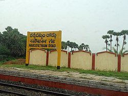
Palasa is one of the twin towns located in the Srikakulam district of Andhra Pradesh, India. The town is situated between Srikakulam and Berhampur. It is categorized as the second grade municipality. Also the town serves as the headquarters of Palasa Mandal.

Payakaraopeta is a City in anakapalli district in the state of Andhra Pradesh in India. Payakaraopeta City is a gate Way of Visakhapatnam. Tuni and Payakaraopeta Cities are Twin Cities in Andhra Pradesh. Payakaraopeta City is fastest growing City in Andhra Pradesh. In the year 2011, The first AC library in united Andhra Pradesh was opened here.
Chilakaluripet is a city in Palnadu district of the Indian state of Andhra Pradesh. It is the Mandal headquarters of Chilakaluripet Mandal in Narasaraopet Revenue Division.

Guntupalli is located in western part of Vijayawada in the Indian state of Andhra Pradesh. It is a Rural area falls under Ibrahimpatnam mandal in Vijayawada revenue division of NTR district. Guntupalli Railway Wagon Workshop is located here. There is a proposal to merge this village into Vijayawada Municipal Corporation (VMC) to form a Greater Vijayawada Municipal Corporation.

Kolakaluru is a neighborhood of Tenali city in Guntur district of the Indian state of Andhra Pradesh. It is located in Tenali mandal of Tenali revenue division. It forms a part of Andhra Pradesh Capital Region.
Vaddeswaram is a Suburb of Vijayawada in Guntur district of the Indian state of Andhra Pradesh. It is located at a distance of 5 km (3.1 mi) from Krishna River, in Tadepalle mandal part of Mangalagiri Tadepalle Municipal Corporation part of Guntur revenue division.