Madugula

Last updated

Madugula
Village
View of fields near Maadugula.jpg
A view of fields near Madugula
Madugula
Dynamic map
India Andhra Pradesh location map (current).svg
Red pog.svg
Madugula
Location in Andhra Pradesh, India
Coordinates: 17°55′00″N82°48′00″E / 17.9167°N 82.8000°E / 17.9167; 82.8000
CountryFlag of India.svg  India
State Andhra Pradesh
District Anakapalli
Elevation
83 m (272 ft)
Languages
  Official Telugu
Time zone UTC+5:30 (IST)
PIN
531 027
Telephone code08934
Vehicle Registration AP31 (Former)
AP39 (from 30 January 2019) [1]

Madugula is a village in Anakapalli district in the state of Andhra Pradesh in India. [2] It was also known as Vaddadi or Vaddadimadugula and was founded by the rulers of the Matsya dynasty. [3] Later, it merged into the kingdom of Nandapur - Jeypore and during the British Raj it remained an independent Zamindari for sometime. Later, in 1915 the zamindaris of Madugula and Pachipenta were purchased by Maharaja Vikram Dev III and they became a part of Jeypore Samasthanam and were governed by the Maharaja of Jeypore until 1947. [4]

Contents

History

The rulers of the Matsya dynasty were the southernmost vassals of the Eastern Ganga dynasty that ruled over Kalinga from 5th century - 15th century and the capital of the Matsya kings was known as 'Vaddadi' derived from the word 'Odda-Adi' which meant the beginning of Odra desh (country of Odia people). Later, it was changed to 'Vaddadimadugula' and in modern age it got divided into two villages within the radius of 11 km known as Waddadi and Madugula. [5]

The most valorous king of the dynasty was Narasimhavardhana Arjun Deva who inherited the kingdom from his father Jayanta Deva Raju in the late 13th century. The Dribbida copperplate grant donated by Narasimhavardhana illustrates the origin of the Matsya dynasty of Vaddadi. The first name mentioned in the Dribbida copperplate is of his grandfather, Manikaditya Raju followed by the name of his father, Jayanta Deva Raju. [5]

Narasimhavardhana Arjun Deva was succeeded by his son Sri Krishnavardhana Jayanta Raju who is known for donating the two villages of Gudisingaram and Gotlam to the temple of Simhachalam. He ruled for a long period and was succeeded by his son Veer Arjuna Deva in the mid-14th century, who was a feudatory of the Ganga king, Narasimha Deva III. Initially, Veer Arjun formed an alliance with the Reddy chiefs of Rajahmundry in order to free his kingdom from the suzerainty of the Gangas who were defeated by Firuz Shah Tughlaq in 1361. However, this attempt went to vain as he died in 1381 and was succeeded by his son, Pratap Arjuna. [5]

The Anaparti and Gopavaram copperplate grants suggest that Kumaragiri Reddy regained his suzerainty over Rajahmundry in 1389 and invaded Cuttack with his able general Katayavema who defeated the Ganga ruler, Narasimha Deva IV and assumed the title of Kataka-Churakara meaning - the destroyer of Cuttack. This indicates that Vaddadi slipped away from the Eastern Ganga kingdom for sometime but later in 1424 the last Ganga king, Bhanudeva IV sent his able general and minister, Kapilendra Deva who defeated and drove out the Reddys to as far as Rajahmundry. Evidently, Pratap Arjuna sent his army to help the Gangas. [5]

Pratap Arjuna had a son named Jayanta Deva Raju II whose daughter Singamma was married to the Silavanshi king, Vishwanath Raj of the neighboring Nandapur kingdom. There are two inscriptions dated 4 and 8 July 1427 that records the marriage of Singamma to Vishwanath Raj of Nandapur. This was believed to be a crucial matrimonial alliance between the families of Matsya and Silavansh. The son of Jayanta Deva Raju II was Singharaju who was a contemporary of Pratap Ganga Raj of Nandapur. [5]

In 1443, Pratap Ganga Raj was succeeded by his son-in-law Vinayak Dev who was a junior prince of a small kingdom ruled by Suryavanshi kings in North Kashmir. In a turn of events, Vinayak Dev migrated to Varanasi and then to Nandapur, where he married Lilavati, the only daughter of Pratap Ganga Raj. Evidently, he inherited the kingdom from his father-in-law and faced rebellion from other Silavanshi claimants. As a result, he was ousted and later helped by the Matsya king, Singharaju who helped him curb the rebellion and reclaim the kingdom of Nandapur. [4]

Singharaju was succeeded by his son Vallabhadeva Raju who performed the famous Agnistoma sacrifice on the bank of Danta near Duttada and constructed the temple of Lord Vallabharaya. He donated a village called Annavaram for the service of Lord Vallabharaya and was succeeded by his son Pratap Sri Ganga Raju. This king ruled as vassal of Prataparudra Deva and later his son Veer Pratap Singharaju served under the same Gajapati. [5]

In later years, after the collapse of the Gajapati Empire in the mid 16th century, the king of Nandapur - Vishwanath Dev Gajapati conquered the former territories of the Gajapatis from Bengal in North to Telangana in south. This was a period when the Matsya kingdom of Vaddadi or Madugula became vassals of Nandapur and later the Kingdom of Jeypore.

Matsya Dynasty of Vadaddi

NameReign beganReign ended
1Manikyaditya Raju11981224
2Jayanta Raju12241257
3Narasimhavardhana Arjuna Deva12571298
4Sri Krishnavardhana Jayanta Raju12981352
5Vir Arjuna Deva13521381
6Pratap Arjuna Deva13811429
7Jayanta Raju II14291448
8Singharaju14481471
9Vallabhadeva Raju14711498
10Pratap Sriranga Raju14981516
11Vira Pratap Singharaju15161541

Geography

Madugula is located at 17°55′00″N82°48′00″E / 17.9167°N 82.8°E / 17.9167; 82.8 . [6] It has an average elevation of 83 meters (275 feet). The place is surrounded by hills, river streams and paddy fields. It is largely inhabited by Telugu speaking populace and has an old palace of the Matsya dynasty. The Endrikaparvatam meaning the 'Crab Hill' is the seventh highest peak of Andhra Pradesh with an elevation of 1568 metres above sea-level. [3]

A historic river called 'Matsyakunda' originates from the hills of Madugula and then turn westwards into Odisha to the erstwhile kingdom of Jeypore. It has a historical significance as it used to flow from the Matsya kingdom to the neighbouring kingdom of the Silavanshis and later Suryavanshis. In the later medieval period, the name of the river changed from Matsyakunda to Machkunda. The river flows as a boundary between Andhra Pradesh and Odisha for almost fifty miles and then completely into Malkangiri. The famous Duduma Waterfalls named after a legendary Rani Duduma is formed in the Machkund river and three kilometres away from these waterfalls is a popular tourist spot called Matsya Tirth. The waterfalls of river Machkund are used for generating electricity under the banner of "Machkund Hydroelectric Project". [7]

Legislative Assembly

Madugula is an assembly constituency in Andhra Pradesh. There are 1,70,350 registered voters in Madugula constituency in 2014 elections.

List of Elected Members: [8]

•2019 - BUDI. MUTYALA NAIDU (Taruva (v))

Related Research Articles

<span class="mw-page-title-main">Northern Circars</span> Division of British Indias Madras Presidency

The Northern Circars was a division of British India's Madras Presidency. It consisted of a narrow slip of territory lying along the western side of the Bay of Bengal from 15° 40′ to 20° 17′ north latitude, in the present-day Indian states of Andhra Pradesh and Odisha. The Subah of Deccan (Hyderabad/Golconda) consisted of 22 circars. These northern circars were five in number and the most prominent ones in the Subah.

<span class="mw-page-title-main">Rayagada district</span> District of Odisha in India

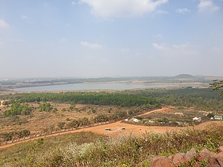
Rayagada district is a district in southern Odisha, a state in India, which became a separate district in October 1992. Its population consists mainly of tribes, primarily the Khonds and the Soras. In addition to Odia, Kui and Sora are spoken by the district's indigenous population. It was founded by Maharajah Biswanatha Deba Gajapati of the Surjyabansha dynasty of Jeypore.

<span class="mw-page-title-main">Jeypore</span> City in Odisha, India

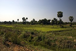
Jeypore is one of the largest towns and a place of historical significance in Koraput district in the Indian state of Odisha. It was established by Vir Vikram Dev in the mid 17th century. The kingdom was defeated by the East India Company in 1777 who declared it a Zamindari or Feudatory of the British Crown and much later got acknowledged as a Princely state until its dissolution in the Dominion of India in 1947.

<span class="mw-page-title-main">Nabarangpur district</span> District of Odisha in India

Nabarangpur district, also known as Nabarangapur district or Nawarangpur district, is a district of Odisha, India. The city of Nabarangpur is the district capital. Most of its population is tribal and the land is heavily forested. It borders Kalahandi and Koraput districts. Nabarangpur district is situated at 19.14′ latitude and 82.32′ longitude at an average elevation of 572 metres (1,877 ft).

<span class="mw-page-title-main">Sri Kurmam</span> Village in Andhra Pradesh, India

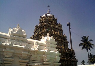
Sri Kurmam also known as Srikurmu or Srikurmais a village near Srikakulam, Andhra Pradesh, India. Srikurmam village is situated at a distance of 14.5 km to the South-east of Srikakulam town. It is in the Gara mandal of Srikakulam district. The village was named after the Srikurmam temple dedicated to Kurma avatar of the Hindu god Vishnu, which was re-established by Eastern Ganga Dynasty King Anantavarman Chodaganga Deva.

The Gajapati Empire, was an empire established by the Suryavamsa dynasty or Routray dynasty, who were a medieval Hindu dynasty in the Indian subcontinent. It originated in the region of Trikalinga and reigned from 1434 to 1541 CE. It succeeded the reign of the Eastern Gangas. Under the Emperor Kapilendra Deva, the Gajapati empire stretched from lower Ganga in the north to Kaveri in the south.

<span class="mw-page-title-main">North Andhra</span> Geographic region of Andhra Pradesh in India

North Andhra or Uttara Andhra, also known as Kalinga Andhra, is a geographic region in the Indian state of Andhra Pradesh. It is between the Eastern Ghats and the coast of the Bay of Bengal. It comprises six northern districts of the state, Srikakulam, Parvathipuram Manyam, Vizianagaram, Visakhapatnam, Alluri Sitharama Raju and Anakapalli. As of 2011 census of India, the region with six districts has a population of 9,338,177.

<span class="mw-page-title-main">History of Andhra Pradesh</span>

The recorded history of Andhra Pradesh, one of the 28 states of 21st-century India, begins in the Vedic period. It is mentioned in Sanskrit epics such as the Aitareya Brahmana. Its sixth-century BCE incarnation Assaka lay between the Godavari and Krishna Rivers, one of sixteen mahajanapadas. The Satavahanas succeeded them, built Amaravati, and reached a zenith under Gautamiputra Satakarni.

Sir Pusapati Ananda Gajapati RajuGCIE was the 10th Maharaja of Vizianagaram.

<span class="mw-page-title-main">Eastern Ganga dynasty</span> Medieval era Indian royal Hindu dynasty

The Eastern Ganga dynasty were a large medieval era Indian royal Hindu dynasty that reigned from Kalinga from as early as the 5th century to the mid 20th century. Eastern Gangas ruled much of the modern region of Odisha in three different phases by the passage of time, known as Early Eastern Gangas (493–1077), Imperial Eastern Gangas (1077–1436) and Khemundi Gangas (1436–1947). They are known as "Eastern Gangas" to distinguish them from the Western Gangas who ruled over Karnataka. The territory ruled by the dynasty consisted of the whole of the modern-day Indian state of Odisha, as well as major parts of north Andhra Pradesh, parts of Chhattisgarh and some southern districts of West Bengal. Odia language got official status in their regime following the evolution of the language from Odra Prakrit. The early rulers of the dynasty ruled from Dantapuram; the capital was later moved to Kalinganagara, and ultimately to Kataka and then to Paralakhemundi.

Poosapati / Pusapati was the ruling clan of the Northern Andhra region, Vizianagaram.

<span class="mw-page-title-main">Majhighariani Temple</span> Hindu temple in Odisha, India

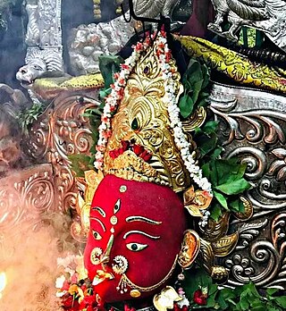
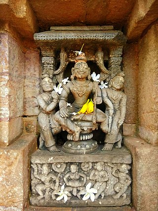
Majhighariani Temple is a shrine to a goddess in the Rayagada township of Odisha. It was built by King Vishwanath Dev Gajapati of the Suryavansh dynasty of Nandapur - Jeypore kingdom. It is believed that he made Rayagada his capital and after the construction of the temple he went on to conquer a vast dominion and expanded his kingdom from parts of Bengal to Telangana in south.

<span class="mw-page-title-main">Kapilendra Deva</span> Founder of the Gajapati Empire

Kapilendra Deva was the founder of the Suryavamsa Gajapati Empire that ruled parts of eastern and southern India with the present-day Odisha as the center of the empire. He ascended to the throne after staging a military coup against the preceding and the last ruler from the Eastern Ganga dynasty, Bhanu Deva IV. He is also referred to as Kapilendra Routray or Sri Sri Kapilendra Deva. Kapilendra claimed descent from the Surya Vamsha of the Mahābhārata and was conferred the regnal title Shri Shri ...(108 times) Gajapati Gaudeshwara NabaKoti Karnata Kalabargeswara i.e. the Lord of Bengal (Gauda), the lord of the Karnataka region or Vijayanagara, the Lord of Kalaburagi and of nine crore subjects.

Biswanathpur is a village in Ganjam district in the south of Odisha, India, bordering Andhra Pradesh. This village owes its name to Vishwanath Dev Gajapati, the Suryavanshi king of Kalinga who founded this place after conducting a royal anicent ritual known as 'Vajapeya Yagna'. It is located southeast of Berhampur and northeast of Ichchapuram.

Jagannatha Gajapati Narayana Deo II was the Odia monarch of the Paralakhemundi Estate in the southern part of today's Odisha and northern Andhra Pradesh. He was from the Eastern Ganga dynasty of the Khemundi Ganga Branch from the year 1736 CE to 1771 CE. He had ascended to the throne at the age of eighteen and at a time when Odisha was torn apart due conflicts between external powers like the Mughals, Marathas, French and British for control of the territory. He invaded khurdha Bhoi dynasty king Birakishore Deva and Vizianagaram estate King Pusapati Vijayarama Raju II and defeated the both kings. He made the last great attempts on his own to revive the lost glory of Odisha and its unique Hindu culture that revolved around the tradition of Jagannath worship. He had defied the authority of the Nizam of Hyderabad and maintained his own sovereignty. He was one of the first rulers who indulged in conflicts with the new European colonists in the eastern part of India. He was also effort bound till the end of his life in framing strategic diplomatic plans to free the ancient land of Odisha from external aggressors and revival of its lost Eastern Ganga Dynasty-Gajapati glory from the past.

<span class="mw-page-title-main">Vikram Deo Verma</span> 25th Maharajah of Jeypore

Maharajah Vikram Dev IV or Vikram Deo Varma was the 25th king of the Suryavansh dynasty that ruled over Kalinga and later Jeypore Samasthanam under the British. A patron of the arts and literature, he was also a writer and a proficient playwright. He was also an administrator, a magistrate for Visakhapatnam by the Madras government in 1914 and involved in the delineation of the state of Odisha.

<span class="mw-page-title-main">Jeypore Estate</span> Kingdom of the Kalinga region of India

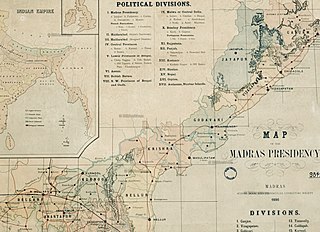
Jeypore Estate or Jeypore Zamindari was a Zamindari estate of the Madras Presidency in British India. Historically it was a kingdom known as Jeypore Kingdom, located in the highlands of the western interiors of the Kalinga region that existed from the mid-15th century to 1777 CE. It was earlier a tributary state of the Gajapati Empire and following its decline in 1540, it gained sovereignty and later became a tributary state of the Qutb Shahis until 1671. The kingdom regained degrees of semi-independence until it became a vassal state of the British in 1777. It eventually formed a part of the linguistic Orissa Province in 1936 upon transfer from the Madras Province and became a part of the independent Union of India in 1947.

Vishwanath Dev Gajapati was the king of Kalinga who established a kingdom in the region of Odisha and Andhra Pradesh, historically known as Kalinga. He belonged to the Shankara dynasty that was installed in the region by his great-grandfather Vinayaka Dev and his wife Lilavati. The Silavamsa king Pratap Ganga Raja died without any male heir, only leaving behind his wife and daughter Lilavati. Vinayak Dev who migrated from Jammu or Kashmir after praying to Kashi Vishwanath married Lilavati. Accordingly, the dynasty was called Shankara dynasty. Vinayak Dev also claimed to belong to the legendary Solar dynasty or Suryavansh.

<span class="mw-page-title-main">Maharaja of Jeypore</span>

Maharaja of Jeypore was the principal title used by the rulers of the Kingdom of Jeypore until its dissolution in 1947. It was also used by the titular rulers until the removal of titles and privileges of all princely states and estates by the 26th amendment of the Constitution of India. However, due to the significance given to the traditional and religious role of a king, evidently, Vishweshwar Dev in 2013 became the Maharaja of Jeypore in pretense.

References

  1. "New 'AP 39' code to register vehicles in Andhra Pradesh launched". The New Indian Express. Vijayawada. 31 January 2019. Archived from the original on 3 February 2019. Retrieved 9 June 2019.
  2. "Mandal wise list of villages in Visakhapatnam district" (PDF). Chief Commissioner of Land Administration. National Informatics Centre. Archived from the original (PDF) on 19 March 2015. Retrieved 6 March 2016.
  3. 1 2 Reddy, Chandrasekhar; Sivaramakrishna, P (January 2014). "Tribal Mahabarata in AP" (PDF). International conference on Mahabarata, S.V. University, Tirupati: 1.
  4. 1 2 Dutt, Tara (2015). Odisha District Gazetteers : Koraput (PDF). Cuttack: General Administration Department, Government of Odisha. p. 38.
  5. 1 2 3 4 5 6 Senapati, Neelmani; Sahu, Nabin Kumar (1966). Orissa District Gazetteers : Koraput. Cuttack: Orissa Government Press. p. 56.
  6. Falling Rain Genomics.Madugula
  7. Chandra Sekhar, A (1967). Census 1961 Andhra Pradesh: District Census Handbook of Visakhapatnam (PDF). Hyderabad: The Government of Andhra Pradesh. pp. CHAPTER 1 - A1.
  8. Election Commission of India.A.P.Assembly results.1978-2004 Archived 2007-09-30 at the Wayback Machine