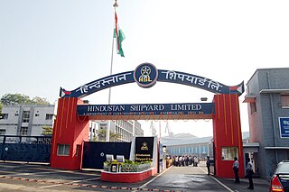
Visakhapatnam is the largest and most populous metropolitan city in the Indian state of Andhra Pradesh. It is between the Eastern Ghats and the coast of the Bay of Bengal. It is the second largest city on the east coast of India after Chennai, and the fourth largest in South India. It is one of the four smart cities of Andhra Pradesh selected under the Smart Cities Mission and is the headquarters of Visakhapatnam district. Vizag is popularly knows as shipbuilding capital of India due to presence of multiple shipyard such as Hindustan Shipyard, Naval Dockyard and being the central naval command of the east coast.

Coastal Andhra, also known as Kosta Andhra, is a geographic region in the Indian state of Andhra Pradesh, comprising the coastal districts of the state between the Eastern Ghats and the Bay of Bengal, from the northern border with Orissa to Rayalaseema in the south. It includes major cities such as Visakhapatnam and Vijayawada as well as the state capital Amaravati and is recognized for its fertile lands, rich cultural heritage, and economic importance. Coastal Andhra plays a significant role in the state's agricultural output, particularly in rice and tobacco production, supported by abundant water resources from the Godavari, Krishna, and Penna rivers.

Srikakulam district is a district in the Indian state of Andhra Pradesh, located in the Uttarandhra region of the state, with its headquarters located at Srikakulam. It is one of the six districts, located in the extreme northeastern direction of the state. It was formerly known as Chicacole, and was under Ganjam district till 1 April 1936, then merged under Vizagapatam district. Srikakulam district forms the core area of Kalinga where most of its historical capitals like Kalinganagari, pithunda, Dantapuram are located.

Visakhapatnam district is one of the six districts in the Uttarandhra region of the Indian state of Andhra Pradesh, headquartered at Visakhapatnam. It is one of the twenty-six districts in Andhra Pradesh state. The district shares borders within the north and east, Vizianagaram district and South Anakapalli district in the south-west and Bay of Bengal in the south. It is also said that visakhpatnam is taken from ishaqapatnam referring to ishaq mandina auliya a saint whose shrine is located nearby the port.

Gajuwaka is a major residential area of Visakhapatnam City, India. This neighborhood of Visakhapatnam is considered the biggest shopping district in Andhra Pradesh by revenue. Though conceived as a residential locality, it is now one of the principal shopping districts of the city. The Gajuwaka area of Visakhapatnam has the highest per capita income in Andhra Pradesh.

Narsipatnam is a census town in Anakapalle district of the Indian state of Andhra Pradesh. It was upgraded from a gram panchayat into municipality in 2012. The town is spread over an area of 42 km2 (16 sq mi) The resting place of the revolutionary Indian freedom fighter Alluri Sitarama Raju is located in Krishna Devi Peta village of From Narsipatnam to labasingi Village 30 km only.. labasingi most popular winter tourism place..so many Tourists enjoy -2 degree's temparature there.. Narsipatnam town is 43 km away from Tuni. And it is 72 km away from Visakhapatnam.
Chodavaram is a town in Anakapalli district in the Indian state of Andhra Pradesh. The town is located on the country's east coast. It falls under Visakhapatnam Metropolitan Region Development Authority. The town has one of the largest cooperative Sugar factories in state.

Kasimkota is a village in Anakapalli district in the state of Andhra Pradesh in India. Kasimkota was one of the notable villages affected by Cyclone Hudhud.

Elamanchili is a town in Anakapalli district of the Indian state of Andhra Pradesh. It is a municipality and also the mandal headquarters of Elamanchili mandal.it is a Second biggest Town in Anakapalle District After Anakapalle. The town is spread over an area of 39 km2 (15 sq mi), which is under the jurisdiction of Visakhapatnam Metropolitan Region Development Authority. This town has historical importance dating back to 7th Century AD.

North Andhra or Uttara Andhra, also known as Kalinga Andhra, is a geographic region in the Indian state of Andhra Pradesh. It is between the Eastern Ghats and the coast of the Bay of Bengal. It comprises six northern districts of the state, Srikakulam, Parvathipuram Manyam, Vizianagaram, Visakhapatnam, half of the Alluri Sitharama Raju district and Anakapalli. Alluri Sitharama Raju district was carved out of Erstwhile Visakhapatnam and East Godavari districts. So, half of the Alluri Sitharamaraju district belongs to North Andhra/ Uttara Andhra and the southern part of this district belongs to Coastal Andhra region/ Godavari region. As of 2011 census of India, the region with six districts has a population of 9,338,177.
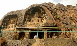
Bojjannakonda and Lingalakonda are two rock-cut caves of Buddhist origin on adjacent hillocks situated near the village of Sankaram, Anakapalle of ancient Kalinga in the Indian state of Andhra Pradesh. The sites are believed to have been established between the 4th and 9th centuries AD, when Buddhism was the majority religion of Sankaram (Sangharam). The original name of Bojjannakonda is Buddina Konda.

Vizagapatam District was a district in the Madras Presidency of British India. Covering an area of 44,600 square kilometres (17,222 sq mi) and sub-divided into 22 taluks.
The Visakhapatnam Urban Development Authority or VUDA was the urban planning agency of Visakhapatnam, in the Indian state of Andhra Pradesh. It was formed in 1978, vide an act of the State Assembly of Andhra Pradesh. Its jurisdiction was expanded in 2018 by merging it with the surrounding mandals to form Visakhapatnam Metropolitan Region Development Authority.

Greater Visakhapatnam Municipal Corporation (GVMC) is the civic body that governs the city of Visakhapatnam, largest city of the Indian state of Andhra Pradesh. Its jurisdiction encompasses an area of 640 km2 (250 sq mi). It is also part of the planning body of the Visakhapatnam Metropolitan Region Development Authority. Established in the year 1979, the executive power of the GVMC is vested in the Municipal Commissioner, an Indian Administrative Service officer appointed by the Government of Andhra Pradesh. The position is held by Saikanth Varma. Golagani Hari Venkata Kumari (YSRCP) was elected as the Mayor and Jiyyani Sridhar (YSRCP) as the Deputy Mayor by the newly elected general body in March 2021. In January 2021, the number of wards were increased to 98 from 81 earlier.

Anakapalli revenue division is an administrative division in the Anakapalli district of the Indian state of Andhra Pradesh. It is one of the two revenue divisions in the district which consists of twelve mandals under its administration. Anakapalli is the divisional headquarters.
Anakapalli mandal is one of the mandals in located in Anakapalli district of the state of Andhra Pradesh, India. It is administered under Anakapalli revenue division and its headquarters are located at Anakapalli. It is bounded by Kasimkota Mandal towards west, Munagapaka Mandal towards South, Paravada Mandal towards East, Achutapuram Mandal towards South.

Sri Varada Narayana Murty Raiwada Reservoir Project or Raiwada Reservoir is a reservoir constructed across the Sarada River near Raiwada village, Devarapalli mandal, Anakapalli district, 58 km from Visakhapatnam city. It is one of the main water sources for Visakhapatnam city. Its capacity is 2,360 tcm, and it is maintained by Irrigation & CAD Dept.

The Administration of Visakhapatnam officially started in 1803, with the municipality of Visakhapatnam being established in 1861. Currently, it is known as the Greater Visakhapatnam Municipal Corporation (GVMC). Its total area is 681 km2 (263 sq mi) with 98 wards and 8 zones. The mayor is elected by corporators who are representative of their wards.

Anakapalli district is a district in the Indian state of Andhra Pradesh. It was formed on 4 April 2022 from Anakapalli and Narsipatnam revenue divisions of the old Visakhapatnam district. The administrative headquarters are at Anakapalli. Sankaram, 3 km from Anakapalli is identified to be developed as the headquarters of the new district.


