
Visakhapatnam, also known as Vizag, Viśākha or Waltair, is the largest and most populous city in the Indian state of Andhra Pradesh. It is between the Eastern Ghats and the coast of the Bay of Bengal. It is the second-largest city on the east coast of India after Chennai, and the fourth-largest in South India. It is one of the four smart cities of Andhra Pradesh selected under the Smart Cities Mission and is the headquarters of Visakhapatnam district. With an estimated output of $43.5 billion, it is the ninth-largest contributor to India's gross domestic product as of 2016.

Vizianagaram district is one of the six districts in the Uttarandhra region of the Indian state of Andhra Pradesh with its headquarters located at Vizianagaram. The district was once the part of ancient Kalinga.Saripilli Dibbilingeswara temple, Jayathi Mallikarjuna Temple are the finest examples of ancient Eastern Ganga Dynasty built monuments in the district. The district is bounded on the east by the district of Srikakulam, north by Parvathipuram Manyam south by Visakhapatnam, Anakapalli, southeast by the Bay of Bengal, and west by Alluri Sitharama Raju district. It was formed on 1 June 1979, with some parts carved from the neighbouring districts of Srikakulam and Visakhapatnam. The district is named after the princely state of Vizianagaram. In 2011, it was the least populous district in Andhra Pradesh.

Srikakulam district is one of the twenty-six districts of the Indian state of Andhra Pradesh, located in the Uttarandhra region of the state, with its headquarters located at Srikakulam. It is one of the six districts, located in the extreme northeastern direction of the state. It was formerly known as Chicacole, and was under Ganjam district till 1936 April 1, then merged under Vizagapatam district .This was once the part of ancient Kalinga.

Visakhapatnam district is one of the six districts in the Uttarandhra region of the Indian state of Andhra Pradesh, headquartered at Visakhapatnam. It is one of the twenty-six districts in Andhra Pradesh state.The district share broders with in the north and east, Vizianagaram district and South Anakapalli district in the south-west and Bay of Bengal in the south.

Nuzvid is a city in Eluru district of the Indian state of Andhra Pradesh. It serves as the administrative headquarters for Nuzvid mandal and Nuzvid revenue division.

Gajuwaka is a major residential area of Visakhapatnam City, India. This neighborhood of Visakhapatnam is considered the biggest shopping district in Andhra Pradesh by revenue. Though conceived as a residential locality, it is now one of the principal shopping districts of the city. The Gajuwaka area of Visakhapatnam has the highest per capita income in Andhra Pradesh.

Tadepalligudem is a city in West Godavari district of the Indian state of Andhra Pradesh. It is a Selection Grade municipality and the mandal headquarters of Tadepalligudem mandal and Tadepalligudem Revenue Division. Tadepalligudem is the second biggest city after Bhimavaram in West Godavari District as per 2011 census in terms of population.
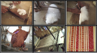
Ponduru is a census town in Srikakulam district of the Indian state of Andhra Pradesh. The town is the mandal headquarters of Ponduru mandal in Srikakulam revenue division. It falls under the Amadalavalasa Assembly Constituency and Srikakulam Loksabha Constituency.
Pedagantyada is a neighbourhood in the city of Visakhapatnam, India. It is one of the 46 mandals in Visakhapatnam District. It is under the administration of Visakhapatnam revenue division and the headquarters is located at Pedagantyada beside Gajuwaka. The Mandal is bounded by Mulagada and Gajuwaka mandals. It is a major Suburb in Visakhapatnam and got merged in Greater Visakhapatnam Municipal Corporation in 2005. Organisations like Visakhapatnam Steel Plant, and Gangavaram Port are located in this area.

Elamanchili is a town or city in Anakapalli district of the Indian state of Andhra Pradesh. It is a municipality and also the mandal headquarters of Elamanchili mandal. The town is spread over an area of 39 km2 (15 sq mi), which is under the jurisdiction of Visakhapatnam Metropolitan Region Development Authority. This town has historical importance dating back to 7th Century AD.

Narasingapalli is a village in Anakapalli district of the Indian state of Andhra Pradesh. It is situated in Kasimkota mandal of Anakapalli revenue division.
Raghu Engineering College (Autonomous) is an engineering college located in the outskirts of the city of Visakhapatnam, Andhra Pradesh, India. Established in 2001, it is situated on NH-43, 37 km away from Visakhapatnam and 15 km away from Vizianagaram. It is an AICTE, New Delhi approved engineering institution and is affiliated to JNTU Kakinada. The chairman is Kalidindi Raghu an academician.

Seethammadhara is a neighborhood in the city of Visakhapatnam, India. The neighborhood is considered as the major residential area in the district. It is located within the jurisdiction of the Greater Visakhapatnam Municipal Corporation, which is responsible for the civic amenities in Seethammadhara. It is located in the central of Visakhapatnam city.

Gopalapatnam is a neighborhood in the city of Visakhapatnam, India. The neighborhood is considered to be the major residential and commercial area in the district. It is located within the jurisdiction of the Greater Visakhapatnam Municipal Corporation, which is responsible for the area's civic amenities. It is located on the western fringe of Visakhapatnam. The Visakhapatnam gas leak occurred in the neighborhood on 7 May 2020.

Malkapuram is a neighbourhood in the city of Visakhapatnam, India. The neighbourhood is considered as the major residential area in the district. It is located within the jurisdiction of the Greater Visakhapatnam Municipal Corporation, which is responsible for the civic amenities in Malkapuram. It is located on the south fringe of Visakhapatnam city.

Andhra Pradesh Capital Region is the metropolitan region area of Andhra Pradesh state capital, the defacto capital city of Andhra Pradesh. Vijayawada is the headquarters and the largest city of the region. It includes the major ancient cities of Vijayawada, Guntur, and Tenali. Andhra Pradesh Capital Region is one of the largest populated urban areas in the world, with its suburbs Vijayawada, Guntur, and Tenali being the 3rd, 24th, 41st most densely populated cities in the world. Vijayawada is the most densely populated city in India while Guntur is 11th and Tenali is the most populous city of 14th place in Andhra Pradesh. Andhra Pradesh Capital Region is the most populated metropolitan area in the state of Andhra Pradesh and 8th in India. Entire region is under the jurisdiction of Andhra Pradesh Capital Region Development Authority, and covers an area of 8,603 km2 (3,322 sq mi) under 58 mandals, of which 29 are in Krishna district and 29 in Guntur district. The capital region covers 18 mandals fully and 11 mandals partially in Guntur district. In Krishna district, it covers 15 mandals fully and 14 mandals partially under the jurisdiction of APCRDA. The capital city is an Urban Notified Area, and will cover 217.23 km2 (83.87 sq mi), within the Andhra Pradesh Capital Region. As of 1 August 2020, Andhra Pradesh proposed three capitals, which are Visakhapatnam as the executive capital, Amaravati as the legislative capital, and Kurnool as the judicial capital, but the process was cancelled and reverted back to the original 2014 plan of a singular capital city at Amaravati on 22 November 2021.
Anakapalle mandal is one of the mandals in located in Anakapalli district of the state of Andhra Pradesh, India. It is administered under Anakapalle revenue division and its headquarters are located at Anakapalle. It is bounded by Kasimkota Mandal towards west, Munagapaka Mandal towards South, Paravada Mandal towards East, Achutapuram Mandal towards South.

Visakhapatnam Metropolitan Region is the metropolitan area covered by the Capital city of Visakhapatnam in the Indian state of Andhra Pradesh. The entire region is spread over the districts of Visakhapatnam,Vizianagaram and Anakapalli. Under the jurisdiction of Visakhapatnam Metropolitan Region Development Authority, it covers an area of 7,328.86 km2 (2,829.69 sq mi) and has a population over of 60 lakhs.
Mulagada is a neighbourhood in the city of Visakhapatnam, India. It is one of the 46 mandals in Visakhapatnam District. It is under the administration of Visakhapatnam revenue division and the headquarters is located at Mulagada. It is located on the south fringe of Visakhapatnam city.

The Visakhapatnam Metropolitan Region Development Authority (VMRDA) is the urban planning agency of Visakhapatnam in the Indian state of Andhra Pradesh. It was formed by expanding the existing Visakhapatnam Urban Development Authority (VUDA). The VMRDA administers the Visakhapatnam Metropolitan Region, spread over an area of 7,328.86 km2 (2,829.69 sq mi) and covers the districts of Visakhapatnam,Vizianagaram and Anakapalli. It was set up for the purposes of planning, co-ordination, supervising, promoting and securing the planned development of the Visakhapatnam Metropolitan Region. It coordinates the development activities of the municipal corporations, municipalities and other local authorities.
