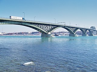
Buffalo is a city in the U.S. state of New York and the county seat of Erie County. It lies in Western New York, at the eastern end of Lake Erie, at the head of the Niagara River, on the United States border with Canada. With a population of 278,349 according to the 2020 census, Buffalo is the 2nd largest city in New York state, 1st being New York City, and the 78th largest city in the United States. Buffalo and the city of Niagara Falls together make up the two-county Buffalo–Niagara Falls Metropolitan Statistical Area (MSA), which had an estimated population of 1.2 million in 2020, making it the 49th-largest MSA in the United States.

California is a state in the Western United States, lying on the American Pacific Coast. It borders Oregon to the north, Nevada and Arizona to the east, and the Mexico to the south. With 39 million residents across an area of 163,696 square miles (423,970 km2), it is the most populous U.S. state, the third-largest by area, and most populated subnational entity in North America. The Greater Los Angeles and San Francisco Bay areas are the nation's second- and fifth-most populous urban regions, with 19 million and 10 million residents respectively. Los Angeles is the state's most populous city and the nation's second-most, after New York. Sacramento is the state's capital.

Louisiana is a state in the Deep South and South Central regions of the United States. It borders Texas to the west, Arkansas to the north, and Mississippi to the east. Of the 50 U.S. states, it ranks 20th in land area and the 25th in population, with roughly 4.6 million residents. Reflecting its French heritage, Louisiana is the only U.S. state with political subdivisions termed parishes, which are equivalent to counties, making it one of only two U.S. states not subdivided into counties. Baton Rouge is the state's capital, and New Orleans, a French Louisiana region, is its largest city with a population of about 383,000 people. Louisiana has a coastline with the Gulf of Mexico to the south; a large part of its eastern boundary is demarcated by the Mississippi River.

Missouri is a landlocked state in the Midwestern region of the United States. Ranking 21st in land area, it borders Iowa to the north, Illinois, Kentucky and Tennessee to the east, Arkansas to the south and Oklahoma, Kansas, and Nebraska to the west. In the south are the Ozarks, a forested highland, providing timber, minerals, and recreation. The Missouri River, after which the state is named, flows through the center and into the Mississippi River, which makes up the eastern border. With over six million residents, it is the 18th-most populous state of the country. The largest urban areas are St. Louis, Kansas City, Springfield, and Columbia; the capital is Jefferson City.
Syracuse is a city in and the county seat of Onondaga County, New York, United States. With a population of 148,620 and a metropolitan area of 662,057, it is the fifth-most populated city and 13th-most populated municipality in the state of New York.

Dili is the capital and largest city of East Timor. It lies on the northern coast of the island of Timor, in a small area of flat land hemmed in by mountains. The climate is tropical, with distinct wet and dry seasons. The city has served as the economic hub and chief port of what is now East Timor since its designation as the capital of Portuguese Timor in 1769. It also serves as the capital of the Dili Municipality, which includes some rural subdivisions in addition to the urban ones that make up the city itself. Dili's growing population is relatively youthful, being mostly of working age. The local language is Tetum; however, residents include many internal migrants from other areas of the country.
Urbanization is the population shift from rural to urban areas, the corresponding decrease in the proportion of people living in rural areas, and the ways in which societies adapt to this change. It can also mean population growth in urban areas instead of rural ones. It is predominantly the process by which towns and cities are formed and become larger as more people begin living and working in central areas.
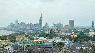
Lagos or Lagos City is the most populous city in Nigeria, with an estimated population of 21 million in 2015. Lagos is the most populous urban area in Africa. Lagos was the national capital of Nigeria until December 1991 following the government's decision to move their capital to Abuja in the centre of the country. Lagos is a major African financial centre and is the economic hub of Lagos State and Nigeria at large. The city has a significant influence on commerce, entertainment, technology, education, politics, tourism, art, and fashion in Africa. Lagos is also among the top ten of the world's fastest-growing cities and urban areas. The megacity has the fourth-highest GDP in Africa and houses one of the largest and busiest seaports on the continent. Due to the large urban population and port traffic volumes, Lagos is classified as a Medium-Port Megacity.

Kennewick is a city in Benton County in the U.S. state of Washington. It is located along the southwest bank of the Columbia River, just southeast of the confluence of the Columbia and Yakima rivers and across from the confluence of the Columbia and Snake rivers. It is the most populous of the three cities collectively referred to as the Tri-Cities. The United States Census Bureau estimated the population to be 84,750 as of 2022, up from 83,921 at the 2020 United States Census.

Morristown is a city in and the county seat of Hamblen County, Tennessee, United States. Morristown also extends into Jefferson County on the western and southern ends. The city lies within the Ridge and Valley of the Appalachians. The city's population was recorded to be 30,431 at the 2020 United States census. It is the principal city of the Morristown Metropolitan Statistical Area, which encompasses all of Grainger, Hamblen, and Jefferson counties. The Morristown metropolitan area is also part of the Knoxville-Morristown-Sevierville Combined Statistical Area.

An urban area, built-up area or urban agglomeration is a human settlement with a high population density and an infrastructure of built environment. This is the core of a metropolitan statistical area in the United States, if it contains a population of more than 50,000.

The National Capital Region is a planning region centered upon the National Capital Territory (NCT) of Delhi in India. It encompasses Delhi and several districts surrounding it from the states of Haryana, Uttar Pradesh, and Rajasthan. The NCR and the associated National Capital Region Planning Board (NCRPB) were created in 1985 to plan the development of the region and to evolve harmonized policies for the control of land-uses and development of infrastructure in the region. Prominent cities of NCR include Delhi, Faridabad, Ghaziabad, Gurgaon and Noida.

New York, sometimes called New York State, is a state in the Northeastern United States. One of the Mid-Atlantic states, it borders the Atlantic Ocean, New England, Canada and the Great Lakes. With almost 19.6 million residents, it is the fourth-most populous state in the United States and eighth-most densely populated as of 2023. New York is the 27th-largest U.S. state by area, with a total area of 54,556 square miles (141,300 km2).

Washington, officially the State of Washington, is a state in the Pacific Northwest region of the United States. It is often referred to as Washington state to distinguish it from the national capital, both named for George Washington. Washington borders the Pacific Ocean to the west, Oregon to the south, Idaho to the east, and the Canadian province of British Columbia to the north. The state was formed from the western part of the Washington Territory, which was ceded by the British Empire in the Oregon Treaty of 1846. It was admitted to the Union as the 42nd state in 1889. Olympia is the state capital, and the most populous city is Seattle.

Arizona is a landlocked state in the Southwestern region of the United States. Arizona is part of the Four Corners region with Utah to the north, Colorado to the northeast, and New Mexico to the east; its other neighboring states are Nevada to the northwest, California to the west and the Mexican states of Sonora and Baja California to the south and southwest. It is the 6th-largest and the 14th-most-populous of the 50 states. Its capital and largest city is Phoenix.
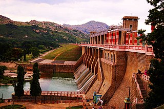
The Krishnagiri Dam is a dam that spans the Thenpennai River by the village of Dhuduganahalli, located in Krishnagiri district, Tamil Nadu, India. The Krishnagiri Dam is also known as Krishnagiri ReservoirProject (KRP) Dam. The KRP Dam is located 7 km (4.3 mi) from Krishnagiri, between Dharmapuri and Krishnagiri which irrigates thousands of acres of land around Krishnagiri. The Dam is operational from 10 November 1957, inaugurated by the Chief Minister of Tamil Nadu K. Kamaraj.

Bangalore, officially Bengaluru, is the capital and largest city of the southern Indian state of Karnataka. It has a population of more than 8 million and a metropolitan population of around 15 million, making it India's third most populous city and fourth most populous urban agglomeration. It is the most populous city and largest urban agglomeration in South India, and is the 27th largest city in the world. Located on the Deccan Plateau, at a height of over 900 m (3,000 ft) above sea level, Bangalore has a pleasant climate throughout the year, with its parks and green spaces earning it the reputation of India's "Garden City". Its elevation is the highest of India's major cities.
Amaravati is the greenfield capital of the Indian state of Andhra Pradesh. It is situated at the heart of the state, on the right bank of the river Krishna in Guntur district. It is near to Dharanikota, the ancient city site nearby, that served as the capital of Satavahana dynasty more than 2,200 years ago.
Dwaraka Tirumala mandal is one of the 28 mandals in Eluru district of the Indian state of Andhra Pradesh. It is under the administration of Eluru revenue division, and the headquarters are located at Dwaraka Tirumala. The mandal is bounded by Jangareddygudem, Koyyalagudem, Kamavarapukota, Nallajerla, Pedavegi, Unguturu, Denduluru and Bhimadole mandals.
