Town Kotha Road

Last updated

Town Kotha Road

టౌన్ కొత్త రోడ్
Neighbourhood
Suryabagh.JPG
Visakhapatnam City Area Map.png
Red pog.svg
Town Kotha Road
Location in Visakhapatnam
Coordinates: 17°42′05″N83°17′46″E / 17.701457°N 83.296178°E / 17.701457; 83.296178 Coordinates: 17°42′05″N83°17′46″E / 17.701457°N 83.296178°E / 17.701457; 83.296178
CountryFlag of India.svg  India
State Andhra Pradesh
District Visakhapatnam
Government
  Body Greater Visakhapatnam Municipal Corporation
Languages
  Official Telugu
Time zone UTC+5:30 (IST)
PIN
530001
Vehicle registration AP-31

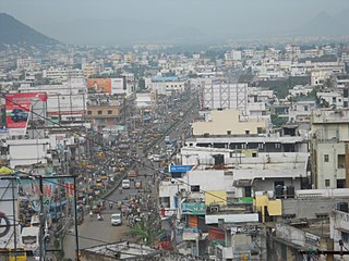
Town Kotha Road, also called Main Road of Visakhapatnam, is one of the important and old business roads in city. [1]

Contents

About

It has a key role in the business of Visakhapatnam, almost all types of goods are available on this road from electronics to clothes. [2]

Transport

It is well connected with all parts of the city. City buses are run to every corner of the city: Gajuwaka, NAD X Road, Malkapuram, Dwaraka Nagar, Maddilapalem, Arilova, Madhurawada, Aganampudi and Visakhapatnam Steel Plant. [3]

APSRTC routes
Route NumberStartEndVia
25KBakkannapalemOld Head Post OfficeMadhurawada, Yendada, Hanumanthuwaka, Maddilapalem, RTC Complex, Jagadamba Centre, Town Kotharoad
25MMarikavalasaOld Head Post OfficeMadhurawada, Yendada, Hanumanthuwaka, Maddilapalem, RTC Complex, Jagadamba Centre, Town Kotharoad
25GGaneshnagarOld Head Post OfficeMadhurawada, Yendada, Hanumanthuwaka, Maddilapalem, RTC Complex, Jagadamba Centre, Town Kotharoad
25SYSR NagarOld Head Post OfficeMadhurawada, Yendada, Hanumanthuwaka, Maddilapalem, RTC Complex, Jagadamba Centre, Town Kotharoad
25EKommadiOld Head Post OfficeMadhurawada, Yendada, Hanumanthuwaka, Maddilapalem, RTC Complex, Jagadamba Centre, Town Kotharoad
52DRavindra NagarOld Head Post OfficeTown Kotharoad, Jagadamba Centre, RTC Complex, Maddilapalem, Hanumanthuwaka
52SSagarnagarOld Head Post OfficeTown Kotharoad, Jagadamba Centre, RTC Complex, Maddilapalem, Hanumanthuwaka, Visalakshinagar
52EPeda RushikondaOld Head Post OfficeTown Kotharoad, Jagadamba Centre, RTC Complex, Maddilapalem, Hanumanthuwaka, Yendada, Rushikonda
20AHB ColonyOld Head Post OfficeTown Kotharoad, Jagadamba Centre, RTC Complex, Gurudwar, Satyam Junction, Seethammadhara
17KBhimiliOld Head Post OfficeTown Kotharoad, Jagadamba Centre, RTC Complex, Siripuram, Pedawaltair, Appughar, Sagarnagar, Rushikonda, Thimmapuram, INS Kalinga
60SimhachalamOld Head Post OfficeTown Kotharoad, Jagadamba Centre, RTC Complex, Maddilapalem, Hanumanthuwaka, Arilova, Adavivaram
60CArilova ColonyOld Head Post OfficeTown Kotharoad, Jagadamba Centre, RTC Complex, Maddilapalem, Hanumanthuwaka
6Old Head Post OfficeSimhachalamTown Kotharoad, Convent, Kancharapalem, NAD Kotharoad, Gopalapatnam
6KOld Head Post OfficeKothavalasaTown Kotharoad, Convent, Kancharapalem, NAD Kotharoad, Gopalapatnam, Vepagunta, Pendurthi
12DRTC ComplexDevarapalleRailway New Colony, Kancharapalem, NAD Kotharoad, Gopalapatnam, Vepagunta, Pendurthi, Kothavalasa
300cRTC ComplexChodavaramRailway New Colony, Kancharapalem, NAD Kotharoad, Gopalapatnam, Vepagunta, Pinagadi, Sabbavaram
333KTown KotharoadK.KotapaduRailway New Colony, Kancharapalem, NAD Kotharoad, Gopalapatnam, Vepagunta, Pinagadi

Related Research Articles

Visakhapatnam Metropolis in Andhra Pradesh, India

Visakhapatnam, formerly known as Vizagapatam is the proposed executive capital of the Indian state of Andhra Pradesh. It is also the most populated and largest city of Andhra Pradesh. It lies between the Eastern Ghats and the coast of the Bay of Bengal. It is the second largest city in the east coast of India after Chennai and also the fourth largest city in South India. It is one of the four smart cities of Andhra Pradesh selected under Smart Cities Mission. It also serves as the headquarters of Visakhapatnam district. With an estimated output of $43.5 billion, the city is the ninth largest contributor to India's overall Gross domestic product as of 2016. In 2020, Visakhapatnam emerged as the finalist in the World Smart City Awards under Living and Inclusion category.

Vizianagaram City in Andhra Pradesh, India

Vizianagaram is a city and the headquarters of Vizianagaram district in the Indian state of Andhra Pradesh. It is central Eastern Ghats, about 24 km (15 mi) west of the Bay of Bengal and 40 km (25 mi) north-northeast of Visakhapatnam. The city has a population of 2,28,025 and was established as the capital of Vizianagaram estate by Raja Vijayaram Raj of Pusapati dynasty. The rulers had a notable role in the history of the region in 18th century and were patrons of education and arts.

Gajuwaka Neighbourhood in Andhra Pradesh, India

Gajuwaka is a major residential area of Visakhapatnam City, India. The neighborhood of Visakhapatnam is considered the biggest shopping district in Andhra Pradesh by revenue. Though conceived as a residential locality, it is now one of the principal shopping districts of the city. Gajuwaka area of Visakhapatnam has the Highest per capita income in Andhra Pradesh.

Tadepalligudem City in Andhra Pradesh, India

Tadepalligudem (TPG) is a City in West Godavari district of the Indian state of Andhra Pradesh. It is a Selection Grade municipality and the mandal headquarters of Tadepalligudem mandal in Eluru revenue division. Tadepalligudem is one of the largest city and fastest growing city in west godavari District as per 2011 census in terms of population.

Anakapalle Place in Andhra Pradesh, India

Anakapalle is a suburb of Visakhapatnam in the Indian state of Andhra Pradesh. The municipality was merged with Greater Visakhapatnam Municipal Corporation. It has the second largest jaggery market of the country.

Bheemunipatnam Place in Andhra Pradesh, India

Bheemunipatnam, is a suburb in the city of Visakhapatnam, India. The town was named after Bhima a character in the Hindu epic Mahabharata. It used to be administered under Bheemunipatnam municipality but in 2017 it was merged into GVMC. It is under the administration of Visakhapatnam revenue division and the headquarters is located at Bheemunipatnam.

Visakhapatnam railway station

Visakhapatnam Junction railway station is a major railway station located in Visakhapatnam, Andhra Pradesh, India. It is administered under the South Coast Railway zone. In 2017, as a part of the Swachh Rail campaign, the Quality Council of India rated Visakhapatnam as the most pristine railway station in the country. The station is a major stop on the Howrah–Chennai main line. For its progress in adopting green concepts through reduction of adverse environmental impacts, the Visakhapatnam railway station was awarded a Platinum rating by the Indian Green Building Council (IGBC). The award is based on the efficiency of the station in six environmental categories, including Sustainable Station Facility; Health, Hygiene and Sanitation; Energy Efficiency; Water Efficiency; Smart Green Initiatives; and Innovation and Development.

Madhurawada Neighbourhood in Visakhapatnam, Andhra Pradesh, India

Madhurawada is a major business and residential area of Visakhapatnam City in the Andhra Pradesh State. It is located on the Visakhapatnam-Vizianagaram stretch of NH16 at around 16 km from Visakhapatnam City Centre. Dr.YSR International Cricket stadium and Shilparamam Jathara of Visakhapatnam also lies in this suburb.

Andhra Pradesh is well connected with various destinations in India, as well as other countries. It has road, rail, airways. With a long coast of Bay of Bengal and many sea ports, it flourishes in sea trade as well. The state has one of the largest railway junctions at Vijayawada and Visakhapatnam Port being one of the largest cargo handling seaport.

Maddilapalem Neighbourhood in Visakhapatnam, Andhra Pradesh, India

Maddilapalem is an area of Visakhapatnam, in the Indian state of Andhra Pradesh.

NAD X Road Neighbourhood in Visakhapatnam, Andhra Pradesh, India

NAD X Road, or NAD Kotha Road, is one of the major junctions and commercial centers in Visakhapatnam, India. It is named for the Naval Armament Depot. The Naval Armament Depot and (NSTL) Naval Science and Technological Laboratories is located here.

Resapuvanipalem Neighbourhood in Visakhapatnam, Andhra Pradesh, India

Resupuvanipalem is a neighborhood in Visakhapatnam, Andhra Pradesh, India.

Isukathota Neighbourhood in Visakhapatnam, Andhra Pradesh, India

Isukathota is a locality in the Maddilapalem neighbourhood of Visakhapatnam, India. It is situated between Sivajipalem and Venkojipalem.

MVP Colony bus station

MVP Colony bus station is a bus station located in Visakhapatnam city of the Indian state of Andhra Pradesh. It is owned by Andhra Pradesh State Road Transport Corporation. It operates buses to all parts of the city and to nearby towns and villages.

One Town (Visakhapatnam) Neighbourhood in Visakhapatnam, Andhra Pradesh, India

One Town also called the "old town", is located in Visakhapatnam City, India. The area falls under the local administrative limits of Greater Visakhapatnam Municipal Corporation,

Transport in Visakhapatnam is the network of roads, railways, rapid transit system in the largest city of Andhra Pradesh. The city of Visakhapatnam also serves as the central hub of transport and logistics on the East coast of India and hence it is called as City Of Destiny.

Seethammapeta Neighbourhood in Visakhapatnam, Andhra Pradesh, India

Seethammpeta is an urban neighborhood in the Indian city of Visakhapatnam. It is one of the middle-income areas of the city..Seethampeta is famous for Dasara and vinyaka chaviti festivals in city.

Ramnagar, Visakhapatnam Neighbourhood in Visakhapatnam, Andhra Pradesh, India

Ramnagar is a neighborhood situated on the central part of Visakhapatnam City, India. The area, which falls under the local administrative limits of Greater Visakhapatnam Municipal Corporation. Ramnagar is located near Dwaraka Nagar, Asilmetta and Daba Gardens.

Transport in Vizianagaram

There are various modes of transportation available in Vizianagaram and its Neighbourhoods. It includes auto rickshaws, bicycles to mass transit systems - such as buses, trains and flights.

CBM Compound Neighbourhood in Visakhapatnam, Andhra Pradesh, India

The CBM Compound, also called the Canadian Baptist Mission Compound (CBM), is a neighborhood situated in the central part of Visakhapatnam City, India. The area, which falls under the local administrative limits of Greater Visakhapatnam Municipal Corporation, is one of the up-market localities. It is a commercial center of the old residential area in the Visakhapatnam City.

References

  1. Sarma, G.V Prasada (3 June 2016). "Fresh move on road-widening in One Town area draws flak". The Hindu. Retrieved 28 September 2017.
  2. Mehtal, Sulogna (5 June 2013). "Dhoklas mix with dosas in Vizag". The Times of India. Retrieved 28 September 2017.
  3. "Local bus timings". aoucr. Retrieved 28 September 2017.