Adarsh Nagar ఆదర్శ్ నగర్ | |
|---|---|
Neighbourhood | |
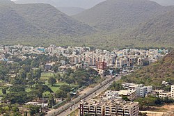 Adarsh Nagar as seen from Kailasagiri | |
 Adarsh Nagar Location in Visakhapatnam | |
| Coordinates: 17°45′47″N83°19′56″E / 17.762925°N 83.332361°E | |
| Country | |
| State | Andhra Pradesh |
| District | Visakhapatnam |
| Government | |
| • Body | Greater Visakhapatnam Municipal Corporation |
| Area | |
• Total | 0.43 km2 (0.17 sq mi) |
| Elevation | 11 m (36 ft) |
| Languages | |
| • Official | Telugu |
| Time zone | UTC+5:30 (IST) |
| PIN | 530040 |
| Vehicle registration | AP-31 |
Adarsh Nagar is a residential neighbourhood in northern Visakhapatnam, Andhra Pradesh, India. It is administered by the Greater Visakhapatnam Municipal Corporation and falls within the Madhurawada Zone. [1]