
Visakhapatnam, formerly known as Vizagapatam is the proposed executive capital of the Indian state of Andhra Pradesh. It is also the most populated and largest city of Andhra Pradesh. It lies between the Eastern Ghats and the coast of the Bay of Bengal. It is the second largest city in the east coast of India after Chennai and also the fourth largest city in South India. It is one of the four smart cities of Andhra Pradesh selected under Smart Cities Mission. It also serves as the headquarters of Visakhapatnam district. With an estimated output of $43.5 billion, the city is the ninth largest contributor to India's overall Gross domestic product as of 2016. In 2020, Visakhapatnam emerged as the finalist in the World Smart City Awards under Living and Inclusion category.

Visakhapatnam district is one of the nine districts in the Coastal Andhra region of the Indian state of Andhra Pradesh, headquartered at Visakhapatnam. It is one of the nine coastal districts of the state, bounded by Odisha in the north, Vizianagaram district in the east, East Godavari district in the south-west and Bay of Bengal in the south.

Gajuwaka is a major residential area of Visakhapatnam City, India. The neighborhood of Visakhapatnam is considered the biggest shopping district in Andhra Pradesh by revenue. Though conceived as a residential locality, it is now one of the principal shopping districts of the city. Gajuwaka area of Visakhapatnam has the Highest per capita income in Andhra Pradesh.

Pedagantyada is a neighbourhood in the city of Visakhapatnam, India. It is one of the 46 mandals in Visakhapatnam District. It is under the administration of Visakhapatnam revenue division and the headquarters is located at Pedagantyada beside Gajuwaka. The Mandal is bounded by Mulagada and Gajuwaka mandals. It is a major Suburb in Visakhapatnam and got merged in Greater Visakhapatnam Municipal Corporation in 2005. Organisations like Visakhapatnam Steel Plant, and Gangavaram Port are located in this area.

Hindustan Shipyard Limited (HSL) is a shipyard located in Visakhapatnam on the east coast of India.
Visakhapatnam West Assembly constituency is a constituency in Visakhapatnam district of Andhra Pradesh. It is one of the seven assembly segments of Visakhapatnam, along with Bheemili, Visakhapatnam East, Visakhapatnam South, Visakhapatnam North and Gajuwaka. Gana Venkata Reddy Naidu Pethakamsetti is the present MLA of the constituency, who won the 2019 Andhra Pradesh Legislative Assembly election from Telugu Desam Party. As of 25 March 2019, there a total of 236,310 electors in the constituency.
Gajuwaka Assembly constituency is a constituency in Visakhapatnam district of Andhra Pradesh. It is one of the seven assembly segments of Visakhapatnam, along with Bheemili, Visakhapatnam East, Visakhapatnam South, Visakhapatnam North and Visakhapatnam West. Nagireddy Tippala is the present MLA of the constituency, who won the 2019 Andhra Pradesh Legislative Assembly election from YSR Congress Party. As of 25 March 2019, in terms of registered number of electors, it is the largest assembly constituency in the state with a total of 309,326 electors.
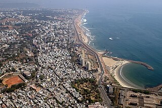
Visakhapatnam is the largest city of Andhra Pradesh. Visakhapatnam has a GDP of $43.5 billion. It is the 9th richest city in India. Fishing industry, road–rail connectivity, many heavy industries like Hindustan Petroleum, Visakhapatnam Steel Plant, Hindustan Shipyard, Visakhapatnam Port Trust, National Thermal Power, Bharat Heavy Electricals, BARC, Naval Science and Technological Laboratory, Naval Dockyard, Dredging Corporation of India, Strategic Petroleum Reserve, NMDC, CONCOR, Andhra Pradesh Medtech Zone etc..

Gopalapatnam is a neighborhood in the city of Visakhapatnam, India. The neighborhood is considered to be the major residential and commercial area in the district. It is located within the jurisdiction of the Greater Visakhapatnam Municipal Corporation, which is responsible for the area's civic amenities. It is located on the western fringe of Visakhapatnam. The Visakhapatnam gas leak occurred in the neighborhood on 7 May, 2020.

Malkapuram is a neighbourhood in the city of Visakhapatnam, India. The neighbourhood is considered as the major residential area in the district. It is located within the jurisdiction of the Greater Visakhapatnam Municipal Corporation, which is responsible for the civic amenities in Malkapuram. It is located on the south fringe of Visakhapatnam city.

Sriharipuram is a neighbourhood in the city of Visakhapatnam, India. The neighbourhood is considered as the major residential area in the district. It is located within the jurisdiction of the Greater Visakhapatnam Municipal Corporation, which is responsible for the civic amenities in Sriharipuram. It is located on the south fringe of Visakhapatnam city.

Aganampudi is a suburb of the city of Visakhapatnam state of Andhra Pradesh, India.
Naidu Thota is a suburb of the city of Visakhapatnam state of Andhra Pradesh, India.

Scindia is an important neighborhood situated on the coastal part of Visakhapatnam City, India. The area, which falls under the local administrative limits of Greater Visakhapatnam Municipal Corporation, it is one of the main industrial area in the city.

Visakhapatnam Metropolitan Region is the metropolitan area covered by the city of Visakhapatnam in the Indian state of Andhra Pradesh. The entire region is spread over the districts of Visakhapatnam and Vizianagaram. Under the jurisdiction of Visakhapatnam Metropolitan Region Development Authority, it covers an area of 7,328.86 km2 (2,829.69 sq mi) and has a population of 60 lakhs.

Visakhapatnam Urban-3 is one of the 46 mandals in Visakhapatnam district of Andhra Pradesh in India. It is administered under Visakhapatnam revenue division and its headquarters is located at Gopalapatnam. The mandal lies on the west fringe of Visakhapatnam city and is bounded by Visakhapatnam Rural to the north and Gajuwaka to the south.
Visakhapatnam Urban-4 is one of the 46 mandals in Visakhapatnam district of Andhra Pradesh in India. It is administered under Visakhapatnam revenue division and its headquarters is located at Mulagada. The mandal lies on the south fringe of Visakhapatnam city and is bounded by Gajuwaka and Pedagantyada mandals.
Visakhapatnam Administration started officially in the year in the year of 1803. later Visakhapatnam Municipality was formed 1861. after years its converted as Municipal Corporation, present day its called as Greater Visakhapatnam Municipal Corporation. GVMC Total area is 681 km2 (263 sq mi) with 98 Ward's and 8 Zones. GVMC Has ruled by a Mayor and Mayor is elected by corporaters Who are representative of their Wards.


