
Andhra Pradesh is a state in the south-eastern coastal region of India. It is the seventh-largest state by area covering an area of 162,975 km2 (62,925 sq mi) and tenth-most populous state with 49,386,799 inhabitants. It is bordered by Telangana to the north-west, Chhattisgarh to the north, Odisha to the north-east, Tamil Nadu to the south, Karnataka to the west and the Bay of Bengal to the east. It has the second longest coastline in India after Gujarat, of about 974 km (605 mi). Andhra Pradesh is the first state to be formed on a linguistic basis in India on 1 October 1953. The state was once a major Buddhist pilgrimage site in the country and a Buddhist learning center which can be seen in many sites in the state in the form of ruins, chaityas and stupas It is also known as the land of the world-famous diamond Koh-i-Noor and many other globally known diamonds due to their source in its Kollur Mine. It is also known as the "rice bowl of India" for being a major producer of rice in India. Its official language is Telugu; one of the classical languages of India, the fourth most spoken language in India and the 11th-most spoken language in the world.

Visakhapatnam, formerly known as Vizagapatam is the proposed executive capital of the Indian state of Andhra Pradesh. It is also the most populated and largest city of Andhra Pradesh. It lies between the Eastern Ghats and the coast of the Bay of Bengal. It is the second largest city in the east coast of India after Chennai and also the fourth largest city in South India. It is one of the four smart cities of Andhra Pradesh selected under Smart Cities Mission. It also serves as the headquarters of Visakhapatnam district. With an estimated output of $43.5 billion, the city is the ninth largest contributor to India's overall Gross domestic product as of 2016. In 2020, Visakhapatnam emerged as the finalist in the World Smart City Awards under Living and Inclusion category.

Araku Valley is a hill station in Visakhapatnam district in the Indian state of Andhra Pradesh, lying 111 km west of Visakhapatnam city. This place is often referred to as Ooty of Andhra. It is a valley in the Eastern Ghats inhabited by different tribes.

Visakhapatnam district is one of the nine districts in the Coastal Andhra region of the Indian state of Andhra Pradesh, headquartered at Visakhapatnam. It is one of the nine coastal districts of the state, bounded by Odisha in the north, Vizianagaram district in the east, East Godavari district in the south-west and Bay of Bengal in the south.

Gajuwaka is a major residential area of Visakhapatnam City, India. The neighborhood of Visakhapatnam is considered the biggest shopping district in Andhra Pradesh by revenue. Though conceived as a residential locality, it is now one of the principal shopping districts of the city. Gajuwaka area of Visakhapatnam has the Highest per capita income in Andhra Pradesh.
Atchutapuram is a neighbourhood in Visakhapatnam district, located in the Indian state of Andhra Pradesh.
Anandapuram is a suburb and a mandal of Visakhapatnam district in the state of Andhra Pradesh, India.

Parawada is a suburb of Visakhapatnam and a Mandal in Visakhapatnam district in the state of Andhra Pradesh in India.

Sabbavaram is a town and educational hub of Visakhapatnam in the state of Andhra Pradesh in India. It has three universities:

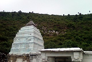
Elamanchili is a town in Visakhapatnam district of the Indian state of Andhra Pradesh. It is a municipality and also the mandal headquarters of Elamanchili mandal. The town is spread over an area of 39 km2 (15 sq mi), which is under the jurisdiction of Visakhapatnam Metropolitan Region Development Authority. This town has historical importance dating back to 7th Century AD.
Uttarandhra is a region consisting of three north coastal districts of the Indian state of Andhra Pradesh. It comprises the districts of Srikakulam, Vizianagaram and Visakhapatnam. As of 2011 census of India, the region with three districts has a population of 9,338,177.

Madhurawada is a major business and residential area of Visakhapatnam City in the Andhra Pradesh State. It is located on the Visakhapatnam-Vizianagaram stretch of NH16 at around 16 km from Visakhapatnam City Centre. Dr.YSR International Cricket stadium and Shilparamam Jathara of Visakhapatnam also lies in this suburb.

The High Court of Andhra Pradesh is the High Court of the Indian state of Andhra Pradesh. The seat of the High Court is currently located at Amaravati. The Government of Andhra Pradesh has however decided and passed a bill in the state legislature to shift the Principle seat of High court to Kurnool.
Bheemili Assembly constituency is a constituency in Visakhapatnam district of Andhra Pradesh, representing the state legislative assembly of Andhra Pradesh in India. It is one of the seven assembly segments of Visakhapatnam namely Srungavarapukota, Visakhapatnam East, Visakhapatnam South, Visakhapatnam North, Visakhapatnam West and Gajuwaka. Muttamsetti Srinivasarao is the present MLA of the constituency, who won the 2019 Andhra Pradesh Legislative Assembly election from YSR Congress Party. As of 25 March 2019, there a total of 305,958 electors in the constituency.
Bhogapuram Airport is a proposed greenfield international airport project to be built near Bhogapuram in Vizianagaram district, 40 kilometers north-east of Visakhapatnam.

The Indian Institute of Management Visakhapatnam (IIMV) is a public business school and Institute of National Importance located in Visakhapatnam, Andhra Pradesh, India. It is one of the twenty Indian Institutes of Management. The institution started the first batch of its Post Graduate Program (PGP) in Management from August 2015. Visakhapatnam is the largest city and the Executive capital of the Indian state of Andhra Pradesh. The city is the administrative headquarters of Visakhapatnam district and the Eastern Naval Command of Indian Navy. Its geographical location is amidst Eastern Ghats mountain range and the coast of Bay of Bengal.

Kommadi is a suburb of the city of Visakhapatnam state of Andhra Pradesh, India.
South Coast Railway Zone (SCoR) is the newest of the 18 railway zones of the Indian Railways and is headquartered at Visakhapatnam, Andhra Pradesh.
Uma Sankara Ganesh is an Indian politician from the YSR Congress Party. He is a current Member of the Andhra Pradesh Legislative Assembly from Narsipatnam constituency for 2019.

