
Andhra Pradesh is a state in the south-eastern coastal region of India. It is the seventh-largest state by area covering an area of 162,975 km2 (62,925 sq mi) and tenth-most-populous state, with 49,386,799 inhabitants. It is bordered by Telangana to the north-west, Chhattisgarh to the north, Odisha to the north-east, Tamil Nadu to the south, Karnataka to the west and the Bay of Bengal to the east. It has the second longest coastline in India after Gujarat, of about 974 km (605 mi). Andhra State was the first state to be formed on a linguistic basis in India on 1 October 1953. On 1 November 1956, Andhra State was merged with the Telugu-speaking areas of the Hyderabad State to form United Andhra Pradesh. In 2014, these merged areas of Hyderabad State were bifurcated from United Andhra Pradesh to form the new state Telangana. The present form of Andhra is similar to Andhra state, but some mandalas like Bhadrachalam are still included in Telangana. Amaravati serves as the capital of present Andhra with the largest city being Visakhapatnam.

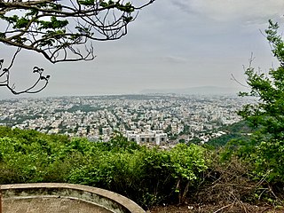
Visakhapatnam, also known as Vizag, Viśākha or Waltair, is the largest and most populous city in the Indian state of Andhra Pradesh. It is between the Eastern Ghats and the coast of the Bay of Bengal. It is the second-largest city on the east coast of India after Chennai, and the fourth-largest in South India. It is one of the four smart cities of Andhra Pradesh selected under the Smart Cities Mission and is the headquarters of Visakhapatnam district. With an estimated output of $43.5 billion, it is the ninth-largest contributor to India's gross domestic product as of 2016.

Bathurst is about 12 kilometres (7.5 mi) inland from Port Alfred, on the R67 road, in the Eastern Cape province of South Africa, and is named after Henry Bathurst, 3rd Earl Bathurst, Secretary of State for the Colonies by Sir Rufane Donkin. Its chief claim to fame is that it was the early administrative centre established by the British Government for the 1820 British Settlers who were sent to the district as a buffer between the Cape Colony and the Xhosa pastoralists who were migrating southwards and westwards along the coast. Bathurst is now part of the Ndlambe Local Municipality in the Sarah Baartman District Municipality of the Eastern Cape.

Madhurawada is a major business and residential area of Visakhapatnam in the state of Andhra Pradesh. It is located on the Visakhapatnam-Vizianagaram stretch of National Highway 16 around 16 km from the city center of Visakhapatnam.

Maddilapalem is an area of Visakhapatnam, in the Indian state of Andhra Pradesh.

Seethammadhara is a neighborhood in the city of Visakhapatnam, India. The neighborhood is considered as the major residential area in the district. It is located within the jurisdiction of the Greater Visakhapatnam Municipal Corporation, which is responsible for the civic amenities in Seethammadhara. It is located in the central of Visakhapatnam city.

Gopalapatnam is a neighborhood in the city of Visakhapatnam, India. The neighborhood is considered to be the major residential and commercial area in the district. It is located within the jurisdiction of the Greater Visakhapatnam Municipal Corporation, which is responsible for the area's civic amenities. It is located on the western fringe of Visakhapatnam. The Visakhapatnam gas leak occurred in the neighborhood on 7 May 2020.

Akkayyapalem is one of the busiest localities in the city of Visakhapatnam, India. It is a part of Visakhapatnam North Constituency.

Sriharipuram is a neighbourhood in the city of Visakhapatnam, India. The neighbourhood is considered as the major residential area in the district. It is located within the jurisdiction of the Greater Visakhapatnam Municipal Corporation, which is responsible for the civic amenities in Sriharipuram. It is located on the south fringe of Visakhapatnam city.
Isukathota is a locality in the Maddilapalem neighbourhood of Visakhapatnam, India. It is situated between Sivajipalem and Venkojipalem.

The Greater Visakhapatnam Municipal Corporation (GVMC) is the civic body that governs the city of Visakhapatnam, largest city of the Indian state of Andhra Pradesh. Its jurisdiction encompasses an area of 681.96 km2 (263.31 sq mi). It is also part of the planning body of the Visakhapatnam Metropolitan Region Development Authority. Established in the year 1979, the executive power of the GVMC is vested in the Municipal Commissioner, an Indian Administrative Service officer appointed by the Government of Andhra Pradesh. The position is held by G. Lakshmisha. Golagani Hari Venkata Kumari (YSRCP) was elected as the Mayor and Jiyyani Sridhar (YSRCP) as the Deputy Mayor by the newly elected general body in March 2021. In January 2021, the number of wards were increased to 98 from 81 earlier.

Bhogapuram International Airport is a proposed greenfield international airport project to be built near Bhogapuram in Vizianagaram district, about 40 kilometres (25 mi) north-east of Visakhapatnam.

The Indian Institute of Management Visakhapatnam (IIMV) is a public business school and Institute of National Importance located in Visakhapatnam, Andhra Pradesh, India. It is one of the twenty Indian Institutes of Management. The institution started the first batch of its Post Graduate Program (PGP) in Management from August 2015. Visakhapatnam is the largest city in Indian state of Andhra Pradesh. The city is the administrative headquarters of Visakhapatnam district and the Eastern Naval Command of Indian Navy. Its geographical location is amidst Eastern Ghats mountain range and the coast of Bay of Bengal.
Abidnagar is a residential area located in Akkayyapalem, Visakhapatnam, India. It comes under Greater Visakhapatnam Municipal Corporation.
HB Colony is a neighborhood situated on the northern part of Visakhapatnam City, India. The area, which falls under the local administrative limits of Greater Visakhapatnam Municipal Corporation, is one of the residential area in the city.
Pithapuram Colony is a neighborhood situated on the central part of Visakhapatnam City, India. The area, which falls under the local administrative limits of Greater Visakhapatnam Municipal Corporation, is about 3.2 km from the Dwaraka bus station..Pithapuram Colony is sourrnded by Maddilapalem and Sivajipalem famous Kala Bharati and ICAI is located hear
Desapatrunipalem is a suburb situated in Visakhapatnam City, India. The area, which falls within the local administrative limits of Greater Visakhapatnam Municipal Corporation, is quite close to the Visakhapatnam Steel Plant site. Desapatrunipalem is a pleasant residential colony, well connected with Gajuwaka, and has experienced a real estate boom, it is one of the fastest developing suburbs in visakhapatnam. the place is famous for its industry oriented suburb as it is one of the main connections of Jawaharlal Nehru Pharma City and NTPC Limited and Rashtriya Ispat Nigam and APSEZ. and it is one of the main destination of employees of various PSU employees.
Soldierpet is one of the oldest neighbourhoods in Visakhapatnam, Andhra Pradesh, India. In the 18th century the area was a residential colony for the British Army.
