
Gajuwaka is a major residential area of Visakhapatnam City, India. This neighborhood of Visakhapatnam is considered the biggest shopping district in Andhra Pradesh by revenue. Though conceived as a residential locality, it is now one of the principal shopping districts of the city. The Gajuwaka area of Visakhapatnam has the highest per capita income in Andhra Pradesh.

Andhra Pradesh State Road Transport Corporation, officially Andhra Pradesh Raastra Roadu Ravaana Samstha, is the state-owned road transport corporation in the Indian state of Andhra Pradesh. Its headquarters is located at NTR Administrative Block of RTC House in Pandit Nehru bus station of Vijayawada. Many other Indian metros & towns in Telangana, Tamil Nadu, Karnataka, Odisha and Chhattisgarh are also linked with the APSRTC services.

Duvvada is a suburban area of Visakhapatnam city, under the Revenue Mandal of Gajuwaka in Greater Visakhapatnam Municipal Corporation. A sub-post Office located at Duvvada with pincode 530046 and 530049.
Pedagantyada is a neighbourhood in the city of Visakhapatnam, India. It is one of the 46 mandals in Visakhapatnam District. It is under the administration of Visakhapatnam revenue division and the headquarters is located at Pedagantyada beside Gajuwaka. The Mandal is bounded by Mulagada and Gajuwaka mandals. It is a major Suburb in Visakhapatnam and got merged in Greater Visakhapatnam Municipal Corporation in 2005. Organisations like Visakhapatnam Steel Plant, and Gangavaram Port are located in this area.
Tungalam is a suburban area in Visakhapatnam, India.

Duvvada railway station located in the Indian state of Andhra Pradesh, serves Duvvada, the southern outskirts of Visakhapatnam. It lies on the Howrah–Chennai main line.

Gopalapatnam is a neighborhood in the city of Visakhapatnam, India. The neighborhood is considered to be the major residential and commercial area in the district. It is located within the jurisdiction of the Greater Visakhapatnam Municipal Corporation, which is responsible for the area's civic amenities. It is located on the western fringe of Visakhapatnam. The Visakhapatnam gas leak occurred in the neighborhood on 7 May 2020.

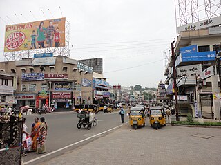
Akkayyapalem is one of the busiest localities in the city of Visakhapatnam, India. It is a part of Visakhapatnam North Constituency.

Arilova is a residential area of Visakhapatnam, Andhra Pradesh, India. It is located on the north fringe of Visakhapatnam city with hills surrounding on opposite sides. It is located beside Kailasagiri. Arilova is a Part of GVMC Greater Visakhapatnam Municipal Corporation, which is responsible for the civic amenities in Arilova.

Malkapuram is a neighbourhood in the city of Visakhapatnam, India. The neighbourhood is considered as the major residential area in the district. It is located within the jurisdiction of the Greater Visakhapatnam Municipal Corporation, which is responsible for the civic amenities in Malkapuram. It is located on the south fringe of Visakhapatnam city.

Sriharipuram is a neighbourhood in the city of Visakhapatnam, India. The neighbourhood is considered as the major residential area in the district. It is located within the jurisdiction of the Greater Visakhapatnam Municipal Corporation, which is responsible for the civic amenities in Sriharipuram. It is located on the south fringe of Visakhapatnam city.

Sheela Nagar is a neighborhood in the southern part of Visakhapatnam City, India. It is under the local administrative limits of Greater Visakhapatnam Municipal Corporation, located about 13 km from the Visakhapatnam Railway Station and about 4 km from the Visakhapatnam Airport.
Transport in Visakhapatnam is the network of roads, railways, rapid transit system in the largest city of Andhra Pradesh. The city of Visakhapatnam also serves as the central hub of transport and logistics on the East coast of India and hence it is called as City Of Destiny.

Aganampudi is a suburb of the city of Visakhapatnam state of Andhra Pradesh, India.
Town Kotha Road, also called Main Road of Visakhapatnam, is one of the important and old business roads in city.
Madhavadhara is a residential area of the city of Visakhapatnam in Andhra Pradesh state, India.

Scindia is an important neighborhood situated on the coastal part of Visakhapatnam City, India. The area, which falls under the local administrative limits of Greater Visakhapatnam Municipal Corporation, it is one of the main industrial area in the city.
Narava is a neighborhood situated on the western part of Visakhapatnam City, India. The area, which falls under the local administrative limits of Greater Visakhapatnam Municipal Corporation, is about 11 km from the Gajuwaka which is industrial area in the city. there are so many engineering and polytechnic colleges are located hear. APSRTC is providing 400S & 6B city bus routes to this area.
Mulagada is a neighbourhood in the city of Visakhapatnam, India. It is one of the 46 mandals in Visakhapatnam District. It is under the administration of Visakhapatnam revenue division and the headquarters is located at Mulagada. It is located on the south fringe of Visakhapatnam city.


