
Visakhapatnam, also known as Vizag, Viśākha or Waltair, is the largest and most populous city in the Indian state of Andhra Pradesh. It is between the Eastern Ghats and the coast of the Bay of Bengal. It is the second-largest city on the east coast of India after Chennai, and the fourth-largest in South India. It is one of the four smart cities of Andhra Pradesh selected under the Smart Cities Mission and serves as the headquarters of Visakhapatnam district. With an estimated output of $43.5 billion, it is the ninth-largest contributor to India's gross domestic product as of 2016.
Transport in Visakhapatnam is the network of roads, railways, rapid transit system in the largest city of Andhra Pradesh. The city of Visakhapatnam also serves as the central hub of transport and logistics on the East coast of India and hence it is called as City Of Destiny.

Kapuluppada is a neighborhood situated on the northern part of Visakhapatnam City, India. The area, which falls under the local administrative limits of Greater Visakhapatnam Municipal Corporation, is about 25 km from the Visakhapatnam Railway Station.

Adavivaram is a neighborhood situated on the western part of Visakhapatnam City, India. The area, which falls under the local administrative limits of Greater Visakhapatnam Municipal Corporation, is about 15 km from the Dwaraka Nagar which is city centre. Adavivaram is located at the foothill of Simhachalam temple and is served by the Visakhapatnam Bus Rapid Transit System.

Visalakshinagar is a neighborhood situated on the northern part of Visakhapatnam City, India. The area, which falls under the local administrative limits of Greater Visakhapatnam Municipal Corporation, is about 5 km from the Dwaraka Nagar which is city centre. Visalakshinagar is located at the entrance of Visakhapatnam City on National Highway 16.
Chinnamushidiwada is a neighborhood situated on the western part of Visakhapatnam City, India. The area, which falls under the local administrative limits of Greater Visakhapatnam Municipal Corporation, is about 18 km from the Dwaraka Bus Station. Chinnamushidiwada is located near to the Pendurthi and is served by the Visakhapatnam Bus Rapid Transit System.
Relli Veedhi is a neighborhood situated on the central part of Visakhapatnam City, India. The area, which falls under the local administrative limits of Greater Visakhapatnam Municipal Corporation, is about 4 km from the Dwaraka Nagar which is city centre. Relli veedhi is located very near to Jagadamba Centre which is primary shopping area to city and this area popularly known for smuggled goods in the city. and Relli Veedhi comes under 23 Ward in Greater Visakhapatnam Municipal Corporation.

Ravindra Nagar is a neighborhood situated on the northern part of Visakhapatnam City, India. The area, which falls under the local administrative limits of Greater Visakhapatnam Municipal Corporation, is about 7 km from the Dwaraka Nagar which is city centre. Ravindra Nagar is located Near to Arilova and surrounded by Kambalakonda Wildlife Sanctuary. its well connected with One Town
Nathayyapalem is a neighborhood situated in the northern part of Visakhapatnam City, India. The area, which falls under the local administrative limits of Greater Visakhapatnam Municipal Corporation, is about 17 km from the Maddilapalem city centre. Nathayyapalem is located between Sheela Nagar and Gajuwaka. It is well connected with Dwaraka Nagar, NAD X Road and Madhurawada.
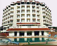
Daspalla Hills is an important neighborhood situated on the coastal part of Visakhapatnam City, India. The area, which falls under the local administrative limits of Greater Visakhapatnam Municipal Corporation, is about 3 km from the Dwaraka Nagar which is city centre. Daspalla Hills is one of the more affluent residential areas of the city.

Pandurangapuram is a neighborhood situated on the coastal part of Visakhapatnam City, India. The area, which falls under the local administrative limits of Greater Visakhapatnam Municipal Corporation, is about 4 km from the Dwaraka Nagar which is city centre. Pandurangapuram is located at the besides of Bay of Bengal and its totally surrounded by Maharanipeta, Kirlampudi Layout and Daspalla Hills.
HB Colony is a neighborhood situated on the northern part of Visakhapatnam City, India. The area, which falls under the local administrative limits of Greater Visakhapatnam Municipal Corporation, is one of the residential area in the city.
Chinna Waltair is a neighborhood situated on the coastal part of Visakhapatnam City, India. The area, which falls under the local administrative limits of Greater Visakhapatnam Municipal Corporation, is about 5 km from the Dwaraka Nagar which is city centre. Chinna Waltair is located at the coast of Bay of Bengal and there are many important visitor attractions like Visakha Museum, Victory at Sea Memorial and the Beach Road.

LIC Building, Visakhapatnam is an 11-storied commercial building in Visakhapatnam, India. It is located on the Jeevitha Bima Road, opposite to the City Central Park. It was one of the tallest buildings in the city.
Pithapuram Colony is a neighborhood situated on the central part of Visakhapatnam City, India. The area, which falls under the local administrative limits of Greater Visakhapatnam Municipal Corporation, is about 3.2 km from the Dwaraka bus station..Pithapuram Colony is sourrnded by Maddilapalem and Sivajipalem famous Kala Bharati and ICAI is located hear

The CBM Compound, also called the Canadian Baptist Mission Compound (CBM), is a neighborhood situated in the central part of Visakhapatnam City, India. The area, which falls under the local administrative limits of Greater Visakhapatnam Municipal Corporation, is one of the up-market localities. It is a commercial center of the old residential area in the Visakhapatnam City.
Narava is a neighborhood situated on the western part of Visakhapatnam City, India. The area, which falls under the local administrative limits of Greater Visakhapatnam Municipal Corporation, is about 11 km from the Gajuwaka which is industrial area in the city. there are so many engineering and polytechnic colleges are located hear. APSRTC is providing 400S & 6B city bus routes to this area.
Gandhigram is a neighborhood city of Visakhapatnam, India. The area, which falls under the local administrative limits of Greater Visakhapatnam Municipal Corporation, is one of the naval and civilian locality in the City. Gandhigram is located between Scindia and Malkapuram and this area is well connected with city buses there are naval hospital and naval schools are situated hear.

Kakani Nagar is a neighborhood situated on the Visakhapatnam City, India. The area, which falls under the local administrative limits of Greater Visakhapatnam Municipal Corporation, is about 3 km from the Visakhapatnam Airport. Kakani Nagar is a well residential colony its well connected with Gajuwaka and Maddilapalem

Appikonda is a neighborhood situated on the southern part of Visakhapatnam City, India,and is about 30 km from the Visakhapatnam. Appikonda is known for the Someswara Swamy Temple.
