A Postal Index Number refers to a six-digit code in the Indian postal code system used by India Post. On 15 August 2023, the PIN system will be celebrated its 51st anniversary.
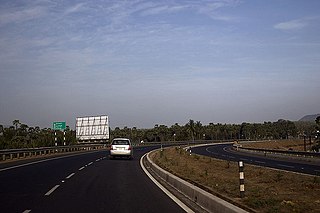
Vadakkencherry is a town and gram panchayat in the Palakkad district, state of Kerala, India. It is located about 35 km from Palakkad along National Highway 544.
Anandapuram is a suburb and a mandal of Visakhapatnam district in the state of Andhra Pradesh, India.

Hafeezpet is a neighbourhood in Hyderabad, India. It is close to Kukatpally, Madhapur and Miyapur. It is administered as Ward No. 109 of Greater Hyderabad Municipal Corporation.
Nagole is a residential and commercial locality in Uppal mandal, Medchal district, Telangana, India.
Pirayiri is a residential and commercial area in Palakkad city.It is located about 8 km (5.0 mi) from the city centre.It belongs to Pirayiri gram panchayat in the Palakkad district, state of Kerala, India.
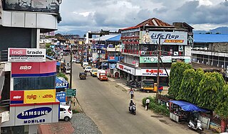
Puthuppariyaram is a suburb of Palakkad city in Palakkad District of Kerala,India. Puthuppariyaram lies on National Highway 966 and is located about 5 km from district headquarters and 124 km from Kozhikode. Puthuppariyaram Panchayat is one among the Panchayat which is supposed to be part of proposed Palakkad Municipal Corporation.
The Battle Of Puthukkudiyirippu was a land battle fought between the Sri Lankan Military, 58 Division, 53 Division and Task Force 8 and the Liberation Tigers of Tamil Eelam (LTTE) for the control of the last stronghold held by the LTTE. This battle is a part of the Northern Theater of Eelam War IV during the Sri Lankan civil war.

Mukundapuram Taluk is a taluk (tehsil) in Irinjalakuda Revenue Division of Thrissur district in the Indian state of Kerala. In 1762 this taluk was formed by Cochin King. When new Chalakudy taluk was formed in 2013 it lost majority of its territory. At present the headquarters of the taluk is Irinjalakuda. and It comprises 29 villages.
- Amballur
- Anandapuram
- Chengallur
- Edathirinji
- Irinjalakkuda
- Kaduppassery
- Kallur
- Karalam
- Karumathra
- Kattur
- Kottanellur
- Madayikonam
- Manavalassery
- Muriyad
- Nellayi
- Nenmanikkara
- Padiyur
- Parappukkara
- Poomangalam
- Porathissery
- Pullur
- Puthenchira
- Thekkumkara
- Thoravu
- Thottippal
- Thrikkur
- Vadakkumkara
- Vallivattam
- Velukkara

Gidijala is a neighbourhood in Anandapuram Mandal, Visakhapatanam District of Andhra Pradesh, India.

Vellanki Nagineedu is an Indian actor who primarily works in Telugu and Tamil films. He was a general manager at Prasad Labs before S. S. Rajamouli offered him a role in his film Maryada Ramanna. He won Nandi Award for Best Villain for his role.
Buchpora is a town on the outskirts of Srinagar, Jammu and Kashmir, India. It is situated on Srinagar-Leh Highway on the eastern side of Anchar Lake. The postal code of the area is 190020. The area is about 12.1 km (7.5 mi) north from Lal Chowk. Most of the current inhabitants of the area are migrants from Downtown Srinagar. During the project of widening the roads in Downtown, numerous houses obstructing the widening of roads were shattered down. The homeless people were given plots of land by state government in neighbouring areas including Buchpora and Soura. Thus government housing colonies were constructed in these areas. there are many areas adjacent to this area, Illahi bagh, Rang pora, Umerhaira, are some of them. The area was an agriculture land but has been converted into a residential area.
Vellanki is a village located in Krishna district in the state of Andhra Pradesh, India.
Londonpur is a village in the Tehsil of Gola Gokaran Nath in the district of Lakhimpur Kheri in the Indian state of Uttar Pradesh. It is part of the Lucknow Division.
Loma is a village in the Jandaha block of Vaishali district in the Indian state of Bihar. It is located more than 30 km from the nearest city of Hajipur.

Byadarahalli is a village in the Mandya district of Karnataka, India.
Anandapuram is a railway station on Birur–Talaguppa branch line of Bangalore–Arsikere–Hubli line. It is located in Shimoga district, Karnataka state, India. The station consists of two platforms, which are not well sheltered. It lacks many facilities including water and sanitation.
Devagiri is the largest village in Haveri Taluk of Haveri district in the Indian state of Karnataka. It is about 7.5 km (4.7 mi) north from the Haveri city in NH-4. Local language is Kannada.
Chamrauli Village in Sumerpur Block in Unnao District of Uttar Pradesh State, India. It comes under Nikha Mau Panchayath. It belongs to Lucknow Division. It is located 51 km towards South from District headquarters Unnao. 82 km from Lucknow. The postal code is 209801
Kovilur is a small Village in Nallampalli Block in Dharmapuri District of Tamil Nadu State, India. It comes under Nallampalli Panchayath. It is located 10 km towards South from District headquarters Dharmapuri. 4 km from Nallampalli.

