Andhra Pradesh is a state in the southern coastal region of India. It is the seventh-largest state with an area of 162,970 km2 (62,920 sq mi) and the tenth-most populous state with 49,577,103 inhabitants. It has shared borders with Chhattisgarh, Odisha, Karnataka, Tamil Nadu, Telangana and the Bay of Bengal. It has the second-longest coastline in India at about 974 km (605 mi). After existence as Andhra State and unified Andhra Pradesh, the state took its present form on 2 June 2014, when the new state of Telangana was formed through bifurcation. Amaravati is the capital of the state, with the largest city being Visakhapatnam. Water sharing disputes and asset division with Telangana are not yet resolved. Telugu, one of the classical languages of India used by the majority of people, is the first official language.

Visakhapatnam, also known as Vizag, Viśākha or Waltair, is the largest and most populous metropolitan city in the Indian state of Andhra Pradesh. It is between the Eastern Ghats and the coast of the Bay of Bengal. It is the second largest city on the east coast of India after Chennai, and the fourth-largest in South India. It is one of the four smart cities of Andhra Pradesh selected under the Smart Cities Mission and is the headquarters of Visakhapatnam district. With an estimated output of $43.5 billion, it is the ninth-largest contributor to India's gross domestic product as of 2016.
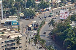
Vijayawada, formerly known as Bezawada, is the second largest city in the Indian state of Andhra Pradesh. It is located on the banks of the Krishna River surrounded by the hills of the Eastern Ghats, known as the Indrakeeladri Hills. The city is home to the important Hindu shrine of Kanaka Durga Temple. It geographically lies on the center spot of Andhra Pradesh. The city has been described as the commercial, political, cultural and educational capital of Andhra Pradesh. It is the administrative headquarters of NTR district. The Prakasam Barrage across the Krishna River connects the NTR and Guntur districts.

Rajahmundry, officially known as Rajamahendravaram, is a city in the Indian state of Andhra Pradesh and district headquarters of East Godavari district. It is the fifth most populated city in the state. During British rule, the district of Rajahmundry was created in the Madras Presidency in 1823. It was reorganised in 1859 and bifurcated into the Godavari and Krishna districts. Rajahmundry was the headquarters of Godavari district, which was further bifurcated into East Godavari and West Godavari districts in 1925. When the Godavari district was bifurcated, Kakinada became the headquarters of East Godavari and Eluru the headquarters of West Godavari. It is administered under Rajahmundry revenue division of the East Godavari district. The city is known for its floriculture, history, culture, agriculture, economy, tourism, and its heritage. It is known as the "Cultural Capital of Andhra Pradesh".

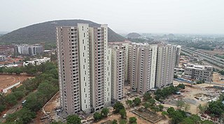
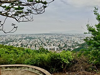
Vizianagaram, also known as Vijayanagaram, is a city and the headquarters of the Vizianagaram district in the Indian state of Andhra Pradesh. It is located in the Eastern Ghats, about 24 km (15 mi) west of the Bay of Bengal and 40 km (25 mi) north-northeast of Visakhapatnam. The city has a population of 228,025 and was established as the capital of the Vizianagaram estate by Raja Vijayaram Raj from the Pusapati dynasty. The rulers had a notable role in the history of the region in the 18th century and were patrons of education and arts.
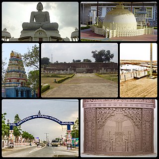
Amaravathi is a village on the banks of the Krishna River, in the Palnadu district of the Indian state of Andhra Pradesh. It is the headquarters of Amaravathi mandal, and forms part of the Andhra Pradesh Capital Region with its headquarters at new Amaravati 35 km (22 mi) east, whose name is also borrowed from that of the older Amaravathi.

Palakollu is a city and the administrative headquarters of Palakollu Mandal in Narasapuram revenue division in West Godavari district of the Indian state of Andhra Pradesh. Palakollu is situated in Coastal Andhra region of the state. It occupies 4.685 square kilometres (1.809 sq mi). As of 2011 census, it had a population of about 61,284 and a Metro population of about 81,199. Palakollu Municipality merged five Grama panchayats of Seven village's on 7 January 2020. The Seven Villages' had a population of 42,932 as of 2011 Census. It around occupies 20.08 square kilometres (7.75 sq mi) and after merged palakollu municipality, It around occupies 24.68 square kilometres (9.53 sq mi) with 35 election wards it is total population of 1,04,216 and making it the third most populous urban area in West Godavari District in Andhra Pradesh. It is a part of Eluru Urban Development Authority.

Gajuwaka is a major residential area of Visakhapatnam City, India. This neighborhood of Visakhapatnam is considered the biggest shopping district in Andhra Pradesh by revenue. Though conceived as a residential locality, it is now one of the principal shopping districts of the city. The Gajuwaka area of Visakhapatnam has the highest per capita income in Andhra Pradesh.
Mandapeta was originally called "Mandavyapuram", which came from Sage Mandukya. Mandapeta is a second-grade municipality established on October 1, 1958 in Dr. B.R. Ambedkar Konaseema district in the Indian state of Andhra Pradesh. It is located at mean elevation of about 15.48 msl at 16.520 N, 81.560 E.
Narasaraopeta is a city and district headquarters of Palnadu District of the Indian state of Andhra Pradesh. The town is a municipality and mandal headquarters of Narasaraopet mandal and Headquarters of Narasaraopet revenue division. The town also is the seat of the court of Additional District Judge. Narasaraopet acts as a melting point for the Palnadu and Delta regions of the district. The town is also referred as the 'Gateway of Palnadu'. The main offices of Nagarjuna Sagar Jawahar Canal Operation & Maintenance Lingamguntla Circle are located in this town. Also it is considered as holy place.

Vinukonda is a town in Palnadu district of the Indian state of Andhra Pradesh. It is a municipality and the headquarters of Vinukonda mandal and administered under Narasaraopet revenue division.
Chilakaluripet is a city in Palnadu district of the Indian state of Andhra Pradesh. It is the Mandal headquarters of Chilakaluripet Mandal in Narasaraopet Revenue Division.
Masab Tank is an anglicized version of Maa-Sahiba Tank. Maa-Sahiba was a title endowed on Hayat Bakshi Begum, wife of Qutub Shahi VI. The ‘Talab’ or tank was built by Khanum Agha, Qutub Shah V's mother, but it became famous after his wife as ‘Talab-e-Maa-Sahiba’. The upgraded ‘Maa Sahiba Talab’ got anglicized to Masab Tank.

Kurmannapalem is an Urban neighbourhood area of the city of Visakhapatnam, India and belongs to the Greater Visakhapatnam Municipal Corporation. It has a population of 60,588 and forms part of the Visakhapatnam city under Gajuwaka Revenue Mandal.

Seethammadhara is a neighborhood in the city of Visakhapatnam, India. The neighborhood is considered as the major residential area in the district. It is located within the jurisdiction of the Greater Visakhapatnam Municipal Corporation, which is responsible for the civic amenities in Seethammadhara. It is located in the central of Visakhapatnam city.
Isukathota is a locality in the Maddilapalem neighbourhood of Visakhapatnam, India. It is situated between Sivajipalem and Venkojipalem.

Amaravati is the capital of the Indian state of Andhra Pradesh. It is located on the right bank of the river Krishna in Guntur district.
Transport in Visakhapatnam is the network of roads, railways, rapid transit system in the largest city of Andhra Pradesh. The city of Visakhapatnam also serves as the central hub of transport and logistics on the East coast of India and hence it is called as City Of Destiny.
HB Colony is a neighborhood situated on the northern part of Visakhapatnam City, India. The area, which falls under the local administrative limits of Greater Visakhapatnam Municipal Corporation, is one of the residential area in the city.