
Visakhapatnam BRTS :-The implementation of the bus rapid transit system has been taken up as a high- capacity public transport system in Visakhapatnam keeping in view the projected multi-fold increase in traffic and constraints of road capacity. A Bus Rapid Transit System (BRTS) was approved for the city under the JNNURM. This project is under construction and will be completed by the end of 2010. The BRTS intends to increase use of public transport from the present share of about 30 per cent to 50 per cent by 2011.

Maddilapalem is an area of Visakhapatnam, in the Indian state of Andhra Pradesh.

Railway New Colony is one of the commercial and residential centers in Visakhapatnam, India. Railway New Colony name coming from Railway colony. Indian Railways Residential area is located here.
Arilova is a residential area of Visakhapatnam, Andhra Pradesh, India. It is located on the north fringe of Visakhapatnam city with hills surrounding on opposite sides. It is located beside Kailasagiri. Arilova is a Part of GVMC Greater Visakhapatnam Municipal Corporation, which is responsible for the civic amenities in Arilova.

Dondaparthy is a mixed residential zone and commercial area in central Visakhapatnam. It is an important neighborhood in Visakhapatnam.

Resupuvanipalem is a neighborhood in Visakhapatnam, Andhra Pradesh, India.

Pothinamallayya Palem or PM Palem, is a residential neighbourhood within Madhurawada situated in Visakhapatnam city in the Indian state of Andhra Pradesh. It is located in the Greater Visakhapatnam Municipal Corporation area. It is located to the north of Visakhapatnam city on National Highway 16 (NH16) to Srikakulam. This place is well connected to other parts of the city such as Asilmetta and Maddilapalem. The only international cricket stadium in Andhra Pradesh is located here.

Abidnagar is a residential area located in Akkayyapalem, Visakhapatnam, India. It comes under Greater Visakhapatnam Municipal Corporation.

Seethammpeta is an urban neighborhood in the Indian city of Visakhapatnam. It is one of the middle-income areas of the city..Seethampeta is famous for Dasara and vinyaka chaviti festivals in city.

Aganampudi is a suburb of the city of Visakhapatnam state of Andhra Pradesh, India.
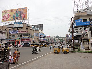
Town Kotha Road, also called Main Road of Visakhapatnam, is one of the important and old business roads in city.

Madhavadhara is a recedential area of the city of Visakhapatnam state of Andhra Pradesh, India.

Adavivaram is a neighborhood situated on the western part of Visakhapatnam City, India. The area, which falls under the local administrative limits of Greater Visakhapatnam Municipal Corporation, is about 15 km from the Dwaraka Nagar which is city centre. Adavivaram is located at the foothill of Simhachalam temple and is served by the Visakhapatnam Bus Rapid Transit System.

Kommadi is a suburb of the city of Visakhapatnam state of Andhra Pradesh, India.

Visalakshinagar is a neighborhood situated on the northern part of Visakhapatnam City, India. The area, which falls under the local administrative limits of Greater Visakhapatnam Municipal Corporation, is about 5 km from the Dwaraka Nagar which is city centre. Visalakshinagar is located at the entrance of Visakhapatnam City on National Highway 16.

Ravindra Nagar is a neighborhood situated on the northern part of Visakhapatnam City, India. The area, which falls under the local administrative limits of Greater Visakhapatnam Municipal Corporation, is about 7 km from the Dwaraka Nagar which is city centre. Ravindra Nagar is located Near to Arilova and surrounded by Kambalakonda Wildlife Sanctuary. its well connected with One Town
Nathayyapalem is a neighborhood situated in the northern part of Visakhapatnam City, India. The area, which falls under the local administrative limits of Greater Visakhapatnam Municipal Corporation, is about 17 km from the Maddilapalem city centre. Nathayyapalem is located between Sheela Nagar and Gajuwaka. It is well connected with Dwaraka Nagar, NAD X Road and Madhurawada.

Ramnagar is a neighborhood situated on the central part of Visakhapatnam City, India. The area, which falls under the local administrative limits of Greater Visakhapatnam Municipal Corporation. Ramnagar is located near Dwaraka Nagar, Asilmetta and Daba Gardens.

Kirlampudi Layout is a neighbourhood of the city of Visakhapatnam, state of Andhra Pradesh, India.
Chinna Waltair is a neighborhood situated on the coastal part of Visakhapatnam City, India. The area, which falls under the local administrative limits of Greater Visakhapatnam Municipal Corporation, is about 5 km from the Dwaraka Nagar which is city centre. Chinna Waltair is located at the coast of Bay of Bengal and there are many important visitor attractions like Visakha Museum, Victory at Sea Memorial and the Beach Road.

