
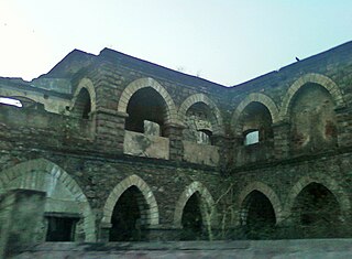
Gwalior is a major city in the central Indian state of Madhya Pradesh; it lies in northern part of Madhya Pradesh and is one of the Counter-magnet cities. Located 343 kilometres (213 mi) south of Delhi, the capital city of India, 120 kilometres (75 mi) from Agra and 414 kilometres (257 mi) from Bhopal, the state capital, Gwalior occupies a strategic location in the Gird region of India. The historic city and its fortress have been ruled by several historic Indian kingdoms. From the Kachchhapaghatas in the 10th century, Tomars in the 13th century, it was passed on to the Mughal Empire, then to the Maratha in 1754, and the Scindia Dynasty of Maratha Empire in the 18th century. In April 2021, It was found that Gwalior had the best air quality index amongst the 4 major cities in Madhya Pradesh.

Visakhapatnam, also known as Vizag, Viśākha or Waltair, is the largest and most populous metropolitan city in the Indian state of Andhra Pradesh. It is between the Eastern Ghats and the coast of the Bay of Bengal. It is the second largest city on the east coast of India after Chennai, and the fourth-largest in South India. It is one of the four smart cities of Andhra Pradesh selected under the Smart Cities Mission and is the headquarters of Visakhapatnam district. With an estimated output of $43.5 billion, it is the ninth-largest contributor to India's gross domestic product as of 2016.

Ujjain or Ujjayinī is a city in Ujjain district of the Indian state of Madhya Pradesh. It is the fifth-largest city in Madhya Pradesh by population and is the administrative centre of Ujjain district and Ujjain division. It is one of the Hindu pilgrimage centres of Sapta Puri famous for the Kumbh Mela held there every 12 years. The famous temple of Mahakaleshwar Jyotirlinga is located in the center of the city. The city has been one of the most prominent trade and political centres of the Indian Subcontinent from the time of the ancient Mahājanapadas until the British colonisation of India.

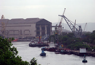
The Scindia Steam Navigation Company, founded in 1919, is the second oldest shipping company of India. The first being the Swadeshi Steam Navigation Company of VOC Pillai in today's Tamilnadu that was founded in 1906.

Visakhapatnam Junction is an important railway station located in Visakhapatnam in the Indian state of Andhra Pradesh. It is on the Howrah–Chennai main line. It is operated by East coast Railway till now and it may take some time to administered under the South Coast Railway zone by Indian Railways. Originally named the Waltair railway station, it was founded in 1896. In 1987, it was renamed Visakhapatnam.

Hindustan Shipyard Limited (HSL) is a shipyard located in Visakhapatnam on the east coast of India.

Visakhapatnam Port is one of twelve major working ports in India and the only major port of Andhra Pradesh. It is India's third largest state-owned port by volume of cargo handled and largest on the Eastern Coast. It is located 880 km from Kolkata Port and 780 km from Chennai Port, almost midway between the two other major ports along the coast of Bay of Bengal.

Greater Visakhapatnam Municipal Corporation (GVMC) is the civic body that governs the city of Visakhapatnam, largest city of the Indian state of Andhra Pradesh. Its jurisdiction encompasses an area of 640 km2 (250 sq mi). It is also part of the planning body of the Visakhapatnam Metropolitan Region Development Authority. Established in the year 1979, the executive power of the GVMC is vested in the Municipal Commissioner, an Indian Administrative Service officer appointed by the Government of Andhra Pradesh. The position is held by G. Lakshmisha. Golagani Hari Venkata Kumari (YSRCP) was elected as the Mayor and Jiyyani Sridhar (YSRCP) as the Deputy Mayor by the newly elected general body in March 2021. In January 2021, the number of wards were increased to 98 from 81 earlier.
One Town also called the "old town", is located in Visakhapatnam City, India. The area falls under the local administrative limits of Greater Visakhapatnam Municipal Corporation,
Transport in Visakhapatnam is the network of roads, railways, rapid transit system in the largest city of Andhra Pradesh. The city of Visakhapatnam also serves as the central hub of transport and logistics on the East coast of India and hence it is called as City Of Destiny.

Adavivaram is a neighborhood situated on the western part of Visakhapatnam City, India. The area, which falls under the local administrative limits of Greater Visakhapatnam Municipal Corporation, is about 15 km from the Dwaraka Nagar which is city centre. Adavivaram is located at the foothill of Simhachalam temple and is served by the Visakhapatnam Bus Rapid Transit System.

Visalakshinagar is a neighborhood situated on the northern part of Visakhapatnam City, India. The area, which falls under the local administrative limits of Greater Visakhapatnam Municipal Corporation, is about 5 km from the Dwaraka Nagar which is city centre. Visalakshinagar is located at the entrance of Visakhapatnam City on National Highway 16.
Nathayyapalem is a neighborhood situated in the northern part of Visakhapatnam City, India. The area, which falls under the local administrative limits of Greater Visakhapatnam Municipal Corporation, is about 17 km from the Maddilapalem city centre. Nathayyapalem is located between Sheela Nagar and Gajuwaka. It is well connected with Dwaraka Nagar, NAD X Road and Madhurawada.

Pandurangapuram is a neighborhood situated on the coastal part of Visakhapatnam City, India. The area, which falls under the local administrative limits of Greater Visakhapatnam Municipal Corporation, is about 4 km from the Dwaraka Nagar which is city centre. Pandurangapuram is located at the besides of Bay of Bengal and its totally surrounded by Maharanipeta, Kirlampudi Layout and Daspalla Hills.
HB Colony is a neighborhood situated on the northern part of Visakhapatnam City, India. The area, which falls under the local administrative limits of Greater Visakhapatnam Municipal Corporation, is one of the residential area in the city.
Narava is a neighborhood situated on the western part of Visakhapatnam City, India. The area, which falls under the local administrative limits of Greater Visakhapatnam Municipal Corporation, is about 11 km from the Gajuwaka which is industrial area in the city. there are so many engineering and polytechnic colleges are located hear. APSRTC is providing 400S & 6B city bus routes to this area.
Gandhigram is a neighborhood city of Visakhapatnam, India. The area, which falls under the local administrative limits of Greater Visakhapatnam Municipal Corporation, is one of the naval and civilian locality in the City. Gandhigram is located between Scindia and Malkapuram and this area is well connected with city buses there are naval hospital and naval schools are situated hear.
Mulagada is a neighbourhood in the city of Visakhapatnam, India. It is one of the 46 mandals in Visakhapatnam District. It is under the administration of Visakhapatnam revenue division and the headquarters is located at Mulagada. It is located on the south fringe of Visakhapatnam city.
Vadlapudi is a neighbourhood in the city of Visakhapatnam, state of Andhra Pradesh, India. It is a suburban area of the city.

