
Visakhapatnam, also known as Vizag, Viśākha or Waltair, is the largest and most populous metropolitan city in the Indian state of Andhra Pradesh. It is between the Eastern Ghats and the coast of the Bay of Bengal. It is the second largest city on the east coast of India after Chennai, and the fourth largest in South India. It is one of the four smart cities of Andhra Pradesh selected under the Smart Cities Mission and is the headquarters of Visakhapatnam district. With an estimated output of $43.5 billion, it is the ninth largest contributor to India's gross domestic product as of 2016.

Visakhapatnam district is one of the six districts in the Uttarandhra region of the Indian state of Andhra Pradesh, headquartered at Visakhapatnam. It is one of the twenty-six districts in Andhra Pradesh state. The district shares borders within the north and east, Vizianagaram district and South Anakapalli district in the south-west and Bay of Bengal in the south.

Dr. Y. S. Rajasekhara Reddy ACA–VDCA Cricket Stadium is a multi-purpose stadium in Visakhapatnam, Andhra Pradesh, India. It is primarily used for international cricket matches. The stadium has two-tiers and was designed to avoid any restricted views, eliminating pillars or columns which come in the field of view of spectators. The pitch is known to be batsman-friendly.

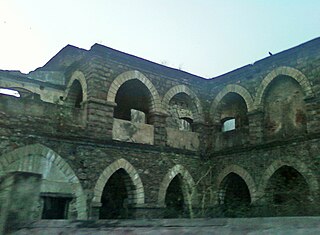
The Kambalakonda Wildlife Sanctuary is a forest located near Visakhapatnam. It has been under the control of Andhra Pradesh Forest Department since 10 March 1970. Earlier the land was under the control of Maharajah of Vizianagaram. It was named after the local hillock Kambalakonda. It is a dry evergreen forest mixed with scrub and meadows and covers an area of 70.70 square kilometers. The indicator species is the Indian leopard.

Visakhapatnam Junction is an important railway station located in Visakhapatnam in the Indian state of Andhra Pradesh. It has a staggering eight platforms with 508 trains passing by everyday. It is on the Howrah–Chennai main line and is being operated by East coast Railway till now and it may take some time to be administered under the South Coast Railway zone by Indian Railways. Originally named the Waltair railway station, it was founded in 1896. It was renamed as Visakhapatnam junction in 1987.

Maddilapalem is an area of Visakhapatnam, in the Indian state of Andhra Pradesh.

Visakhapatnam Airport, officially known as Visakhapatnam International Airport, is a customs airport in Visakhapatnam, Andhra Pradesh, India. It also operates as a civil enclave on an Indian Navy airbase named INS Dega. It lies between the city localities of NAD X Road and Gajuwaka. The airport covers an area of 350 acres. The airport has experienced significant growth since the beginning of the 21st century, with the construction of a new terminal and runway and the commencing of international flights.

Greater Visakhapatnam Municipal Corporation (GVMC) is the civic body that governs the city of Visakhapatnam, largest city of the Indian state of Andhra Pradesh. Its jurisdiction encompasses an area of 640 km2 (250 sq mi). It is also part of the planning body of the Visakhapatnam Metropolitan Region Development Authority. Established in the year 1979, the executive power of the GVMC is vested in the Municipal Commissioner, an Indian Administrative Service officer appointed by the Government of Andhra Pradesh. The position is held by Saikanth Varma. Golagani Hari Venkata Kumari (YSRCP) was elected as the Mayor and Jiyyani Sridhar (YSRCP) as the Deputy Mayor by the newly elected general body in March 2021. In January 2021, the number of wards were increased to 98 from 81 earlier.
GMR Visakhapatnam International Airport is an international airport and a greenfield airport under construction at Bhogapuram in Vizianagaram district, about 40 kilometres (25 mi) north-east of Visakhapatnam.
One Town also called the "old town", is located in Visakhapatnam City, India. The area falls under the local administrative limits of Greater Visakhapatnam Municipal Corporation,
Transport in Visakhapatnam is the network of roads, railways, rapid transit system in the largest city of Andhra Pradesh. The city of Visakhapatnam also serves as the central hub of transport and logistics on the East coast of India and hence it is called as City Of Destiny.
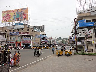
Town Kotha Road, also called Main Road of Visakhapatnam, is one of the important and old business roads in city.

Kapuluppada is a neighborhood situated on the northern part of Visakhapatnam City, India. The area, which falls under the local administrative limits of Greater Visakhapatnam Municipal Corporation, is about 25 km from the Visakhapatnam Railway Station.

Adavivaram is a neighborhood situated on the western part of Visakhapatnam City, India. The area, which falls under the local administrative limits of Greater Visakhapatnam Municipal Corporation, is about 15 km from the Dwaraka Nagar which is city centre. Adavivaram is located at the foothill of Simhachalam temple and is served by the Visakhapatnam Bus Rapid Transit System.

Visalakshinagar is a neighborhood situated on the northern part of Visakhapatnam City, India. The area, which falls under the local administrative limits of Greater Visakhapatnam Municipal Corporation, is about 5 km from the Dwaraka Nagar which is city centre. Visalakshinagar is located at the entrance of Visakhapatnam City on National Highway 16.
Chinnamushidiwada is a neighborhood situated on the western part of Visakhapatnam City, India. The area, which falls under the local administrative limits of Greater Visakhapatnam Municipal Corporation, is about 18 km from the Dwaraka Bus Station. Chinnamushidiwada is located near to the Pendurthi and is served by the Visakhapatnam Bus Rapid Transit System.

Scindia is an important neighborhood situated on the coastal part of Visakhapatnam City, India. The area, which falls under the local administrative limits of Greater Visakhapatnam Municipal Corporation, it is one of the main industrial area in the city.

The CBM Compound, also called the Canadian Baptist Mission Compound (CBM), is a neighborhood situated in the central part of Visakhapatnam City, India. The area, which falls under the local administrative limits of Greater Visakhapatnam Municipal Corporation, is one of the up-market localities. It is a commercial center of the old residential area in the Visakhapatnam City.
Mulagada is a neighbourhood in the city of Visakhapatnam, India. It is one of the 46 mandals in Visakhapatnam District. It is under the administration of Visakhapatnam revenue division and the headquarters is located at Mulagada. It is located on the south fringe of Visakhapatnam city.
Sri Someswara Swamy Temple is a temple to Shiva located in Appikonda, Visakhapatnam.
