
Arilova is a residential area of Visakhapatnam, Andhra Pradesh, India. It is located on the north fringe of Visakhapatnam city with hills surrounding on opposite sides. It is located beside Kailasagiri. Arilova is a Part of GVMC Greater Visakhapatnam Municipal Corporation, which is responsible for the civic amenities in Arilova.

Greater Visakhapatnam Municipal Corporation (GVMC) is the civic body that governs the city of Visakhapatnam, largest city of the Indian state of Andhra Pradesh. Its jurisdiction encompasses an area of 640 km2 (250 sq mi). It is also part of the planning body of the Visakhapatnam Metropolitan Region Development Authority. Established in the year 1979, the executive power of the GVMC is vested in the Municipal Commissioner, an Indian Administrative Service officer appointed by the Government of Andhra Pradesh. The position is held by Saikanth Varma. Golagani Hari Venkata Kumari (YSRCP) was elected as the Mayor and Jiyyani Sridhar (YSRCP) as the Deputy Mayor by the newly elected general body in March 2021. In January 2021, the number of wards were increased to 98 from 81 earlier.
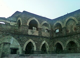
One Town also called the "old town", is located in Visakhapatnam City, India. The area falls under the local administrative limits of Greater Visakhapatnam Municipal Corporation,

Kapuluppada is a neighborhood situated on the northern part of Visakhapatnam City, India. The area, which falls under the local administrative limits of Greater Visakhapatnam Municipal Corporation, is about 25 km from the Visakhapatnam Railway Station.

Adavivaram is a neighborhood situated on the western part of Visakhapatnam City, India. The area, which falls under the local administrative limits of Greater Visakhapatnam Municipal Corporation, is about 15 km from the Dwaraka Nagar which is city centre. Adavivaram is located at the foothill of Simhachalam temple and is served by the Visakhapatnam Bus Rapid Transit System.

Visalakshinagar is a neighborhood situated on the northern part of Visakhapatnam City, India. The area, which falls under the local administrative limits of Greater Visakhapatnam Municipal Corporation, is about 5 km from the Dwaraka Nagar which is city centre. Visalakshinagar is located at the entrance of Visakhapatnam City on National Highway 16.
Chinnamushidiwada is a neighborhood situated on the western part of Visakhapatnam City, India. The area, which falls under the local administrative limits of Greater Visakhapatnam Municipal Corporation, is about 18 km from the Dwaraka Bus Station. Chinnamushidiwada is located near to the Pendurthi and is served by the Visakhapatnam Bus Rapid Transit System.
Relli Veedhi is a neighborhood situated on the central part of Visakhapatnam City, India. The area, which falls under the local administrative limits of Greater Visakhapatnam Municipal Corporation, is about 4 km from the Dwaraka Nagar which is city centre. Relli veedhi is located very near to Jagadamba Centre which is primary shopping area to city and this area popularly known for smuggled goods in the city. and Relli Veedhi comes under 23 Ward in Greater Visakhapatnam Municipal Corporation.

Ravindra Nagar is a neighborhood situated on the northern part of Visakhapatnam City, India. The area, which falls under the local administrative limits of Greater Visakhapatnam Municipal Corporation, is about 7 km from the Dwaraka Nagar which is city centre. Ravindra Nagar is located Near to Arilova and surrounded by Kambalakonda Wildlife Sanctuary. its well connected with One Town
Daspalla Hills is an important neighborhood situated on the coastal part of Visakhapatnam City, India. The area, which falls under the local administrative limits of Greater Visakhapatnam Municipal Corporation, is about 3 km from the Dwaraka Nagar which is city centre. Daspalla Hills is one of the more affluent residential areas of the city.

Pandurangapuram is a neighborhood situated on the coastal part of Visakhapatnam City, India. The area, which falls under the local administrative limits of Greater Visakhapatnam Municipal Corporation, is about 4 km from the Dwaraka Nagar which is city centre. Pandurangapuram is located at the besides of Bay of Bengal and its totally surrounded by Maharanipeta, Kirlampudi Layout and Daspalla Hills.

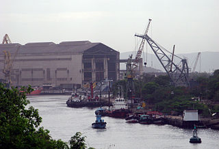
Scindia is an important neighborhood situated on the coastal part of Visakhapatnam City, India. The area, which falls under the local administrative limits of Greater Visakhapatnam Municipal Corporation, it is one of the main industrial area in the city.
HB Colony is a neighborhood situated on the northern part of Visakhapatnam City, India. The area, which falls under the local administrative limits of Greater Visakhapatnam Municipal Corporation, is one of the residential area in the city.
Pithapuram Colony is a neighborhood situated on the central part of Visakhapatnam City, India. The area, which falls under the local administrative limits of Greater Visakhapatnam Municipal Corporation, is about 3.2 km from the Dwaraka bus station..Pithapuram Colony is sourrnded by Maddilapalem and Sivajipalem famous Kala Bharati and ICAI is located hear

Waltair Uplands is a neighbourhood situated in the central part of Visakhapatnam City. The area, which falls under the local administrative limits of Greater Visakhapatnam Municipal Corporation, is one of the most expensive residential and commercial areas in the city. Waltair Uplands is located between Ramnagar and Siripuram and is known for the city's famous coffee shops like Third wave of coffee, Barista Lavazza, Yallop Gourmet Lavazza and Café Coffee Day. Waltair Uplands has become an area in which young people congregate. It is also known for its many shopping outlets.

The CBM Compound, also called the Canadian Baptist Mission Compound (CBM), is a neighborhood situated in the central part of Visakhapatnam City, India. The area, which falls under the local administrative limits of Greater Visakhapatnam Municipal Corporation, is one of the up-market localities. It is a commercial center of the old residential area in the Visakhapatnam City.
Narava is a neighborhood situated on the western part of Visakhapatnam City, India. The area, which falls under the local administrative limits of Greater Visakhapatnam Municipal Corporation, is about 11 km from the Gajuwaka which is industrial area in the city. there are so many engineering and polytechnic colleges are located hear. APSRTC is providing 400S & 6B city bus routes to this area.
Gandhigram is a neighborhood city of Visakhapatnam, India. The area, which falls under the local administrative limits of Greater Visakhapatnam Municipal Corporation, is one of the naval and civilian locality in the City. Gandhigram is located between Scindia and Malkapuram and this area is well connected with city buses there are naval hospital and naval schools are situated hear.
Desapatrunipalem is a suburb situated in Visakhapatnam City, India. The area, which falls within the local administrative limits of Greater Visakhapatnam Municipal Corporation, is quite close to the Visakhapatnam Steel Plant site. Desapatrunipalem is a pleasant residential colony, well connected with Gajuwaka, and has experienced a real estate boom.
Chengal Rao Peta is one of the oldest settlements in the city of Visakhapatnam in the Indian state of Andhra Pradesh.The area, which falls under the local administrative limits of Greater Visakhapatnam Municipal Corporation, is about 4 km from the Dwaraka bus station.

