
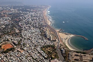
Visakhapatnam, also known as Vizag, Viśākha or Waltair, is the largest and most populous metropolitan city in the Indian state of Andhra Pradesh. It is between the Eastern Ghats and the coast of the Bay of Bengal. It is the second largest city on the east coast of India after Chennai, and the fourth-largest in South India. It is one of the four smart cities of Andhra Pradesh selected under the Smart Cities Mission and is the headquarters of Visakhapatnam district. With an estimated output of $43.5 billion, it is the ninth-largest contributor to India's gross domestic product as of 2016.

Visakhapatnam district is one of the six districts in the Uttarandhra region of the Indian state of Andhra Pradesh, headquartered at Visakhapatnam. It is one of the twenty-six districts in Andhra Pradesh state. The district shares borders within the north and east, Vizianagaram district and South Anakapalli district in the south-west and Bay of Bengal in the south.

Gajuwaka is a major residential area of Visakhapatnam City, India. This neighborhood of Visakhapatnam is considered the biggest shopping district in Andhra Pradesh by revenue. Though conceived as a residential locality, it is now one of the principal shopping districts of the city. The Gajuwaka area of Visakhapatnam has the highest per capita income in Andhra Pradesh.

Bheemunipatnam, is a suburb of Visakhapatnam, India. The town was named after Bhima, a character in the Hindu epic Mahabharata. It formerly administered under the Bheemunipatnam municipality, but merged into GVMC in 2017. It is currently under the administration of Bheemunipatnam revenue division and the headquarters is located at Bheemunipatnam.

Duvvada is a suburban area of Visakhapatnam city, under the Revenue Mandal of Gajuwaka in Greater Visakhapatnam Municipal Corporation. A sub-post Office located at Duvvada with pincode 530046 and 530049.

Pendurthi is a neighbourhood in the city of Visakhapatnam, India. The neighbourhood is considered as the major residential and commercial area in the city. It is located within the jurisdiction of the Greater Visakhapatnam Municipal Corporation, which is responsible for the civic amenities in Pendurthi. It is located on the west fringe of Visakhapatnam city. Pendurthi is one of the peaceful neighborhoods of Vizag.

Kurmannapalem is an Urban neighbourhood area of the city of Visakhapatnam, India and belongs to the Greater Visakhapatnam Municipal Corporation. It has a population of 60,588 and forms part of the Visakhapatnam city under Gajuwaka Revenue Mandal.
Gangavaram Port is a port located in Visakhapatnam, Andhra Pradesh. Inaugurated in July 2009, it has a depth of 21m. It is managed by Gangavaram Port Ltd., a special-purpose company floated by Mr. DVS Raju, who serves as its chairman and managing director. The company is owned by the DVS Raju Group (58.1%), Adani Ports (31.5%) and the Andhra Pradesh Government (10.4%).

Madhurawada is a major business and residential area of Visakhapatnam in the state of Andhra Pradesh. It is located on the Visakhapatnam-Vizianagaram stretch of National Highway 16 around 16 km from the city center of Visakhapatnam.
Visakhapatnam is the largest city of Andhra Pradesh. Visakhapatnam has a GDP of $43.5 billion. It is the 9th richest city in India. Fishing industry, road–rail connectivity, many heavy industries like Hindustan Petroleum, Visakhapatnam Steel Plant, Hindustan Shipyard, Visakhapatnam Port Trust, National Thermal Power, Bharat Heavy Electricals, BARC, Naval Science and Technological Laboratory, Naval Dockyard, Dredging Corporation of India, Strategic Petroleum Reserve, NMDC, CONCOR, Andhra Pradesh Medtech Zone etc..
Andhra Pradesh is well connected with various destinations in India, as well as other countries. It has road, rail, airways. With a long coast of Bay of Bengal and many sea ports, it flourishes in sea trade as well. The state has one of the largest railway junctions at Vijayawada and Visakhapatnam Port being one of the largest cargo handling seaport.

Gopalapatnam is a neighborhood in the city of Visakhapatnam, India. The neighborhood is considered to be the major residential and commercial area in the district. It is located within the jurisdiction of the Greater Visakhapatnam Municipal Corporation, which is responsible for the area's civic amenities. It is located on the western fringe of Visakhapatnam. The Visakhapatnam gas leak occurred in the neighborhood on 7 May 2020.

Arilova is a residential area of Visakhapatnam, Andhra Pradesh, India. It is located on the north fringe of Visakhapatnam city with hills surrounding on opposite sides. It is located beside Kailasagiri. Arilova is a Part of GVMC Greater Visakhapatnam Municipal Corporation, which is responsible for the civic amenities in Arilova.

Malkapuram is a neighbourhood in the city of Visakhapatnam, India. The neighbourhood is considered as the major residential area in the district. It is located within the jurisdiction of the Greater Visakhapatnam Municipal Corporation, which is responsible for the civic amenities in Malkapuram. It is located on the south fringe of Visakhapatnam city.

Sriharipuram is a neighbourhood in the city of Visakhapatnam, India. The neighbourhood is considered as the major residential area in the district. It is located within the jurisdiction of the Greater Visakhapatnam Municipal Corporation, which is responsible for the civic amenities in Sriharipuram. It is located on the south fringe of Visakhapatnam city.

Allipuram is one of the oldest suburbs in Visakhapatnam, Andhra Pradesh, India, close to Visakhapatnam Railway Station. It is near shore to Bay of Bengal. In 1753, Nizam Fauzdar Zafar Ali Khan ruled Visakhapatnam as the center of Chicaco. Allipuram was once a prosperous village, which was frequented by traders who picked up the produce of smiths and weavers. More importantly, the village was once known as Alivelu Manga Puram. Over time it became Allipuram in popular usage. As part of the Salt Satyagraha, Mahatma Gandhi walked along the Allipuram main road to the coast. Because of this, the locals set up a statue of Gandhi on the main road.
Transport in Visakhapatnam is the network of roads, railways, rapid transit system in the largest city of Andhra Pradesh. The city of Visakhapatnam also serves as the central hub of transport and logistics on the East coast of India and hence it is called as City Of Destiny.
Madhavadhara is a residential area of the city of Visakhapatnam in Andhra Pradesh state, India.
Mulagada is a neighbourhood in the city of Visakhapatnam, India. It is one of the 46 mandals in Visakhapatnam District. It is under the administration of Visakhapatnam revenue division and the headquarters is located at Mulagada. It is located on the south fringe of Visakhapatnam city.


