
Transport in India consists of transport by land, water and air. Road transport is the primary mode of transport for most Indian citizens, and India's road transport systems are among the most heavily used in the world.

Chennai, formerly known as Madras, is the capital city of Tamil Nadu, the southernmost state of India. It is the state's primate city and is located on the Coromandel Coast of the Bay of Bengal. According to the 2011 Indian census, Chennai is the sixth-most populous city in India and forms the fourth-most populous urban agglomeration. Incorporated in 1688, the Greater Chennai Corporation is the oldest municipal corporation of India and the second oldest in the world after London.

New Delhi, is the capital of India and a part of the National Capital Territory of Delhi (NCT). New Delhi is the seat of all three branches of the Government of India, hosting the Rashtrapati Bhavan, Sansad Bhavan, and the Supreme Court. New Delhi is a municipality within the NCT, administered by the NDMC, which covers mostly Lutyens' Delhi and a few adjacent areas. The municipal area is part of a larger administrative district, the New Delhi district.

Thiruvananthapuram, commonly shortened to TVM or by its former name Trivandrum, is the capital city of the Indian state of Kerala. It is the most populous city in Kerala with a population of 957,730 as of 2011. The encompassing urban agglomeration population is around 1.68 million. Located on the west coast of India near the extreme south of the mainland, Thiruvananthapuram is a major information technology hub in Kerala and contributes 55% of the state's software exports as of 2016. Referred to by Mahatma Gandhi as the "Evergreen city of India", the city is characterised by its undulating terrain of low coastal hills.

Kochi, also known by its former name Cochin, is a major port city along the Malabar Coast of India bordering the Laccadive Sea. It is part of the district of Ernakulam in the state of Kerala. The city is also commonly referred to as Ernakulam. As of 2011, the Kochi Municipal Corporation had a population of 677,381 over an area of 94.88 km2, and the larger Kochi urban agglomeration had over 2.1 million inhabitants within an area of 440 km2, making it the largest and the most populous metropolitan area in Kerala. Kochi city is also part of the Greater Cochin development region and is classified as a Tier-II city by the Government of India. The civic body that governs the city is the Kochi Municipal Corporation, which was constituted in the year 1967, and the statutory bodies that oversee its development are the Greater Cochin Development Authority (GCDA) and the Goshree Islands Development Authority (GIDA).

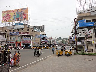
Mysore, officially Mysuru, is the second-most populous city in the southern Indian state of Karnataka. It is the headquarters of Mysore district and Mysore division. As the traditional seat of the Wadiyar dynasty, the city functioned as the capital of the Kingdom of Mysore for almost six centuries. Known for its heritage structures, palaces, and its culture, Mysore has been called the "City of Palaces", the "Heritage City", and the "Cultural Capital of Karnataka". It is one of the cleanest cities in India according to the Swachh Survekshan.
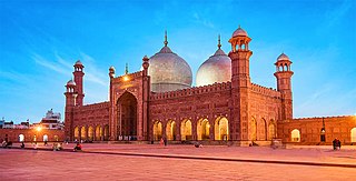
Lahore is the capital and largest city of the Pakistani province of Punjab. It is the second largest city in Pakistan, after Karachi, and 26th largest in the world, with a population of over 13 million. Located in north-eastern Punjab along the River Ravi, it is the largest Punjabi-speaking city in the world. Lahore is one of Pakistan's major industrial and economic hubs. It has been the historic capital and cultural centre of the wider Punjab region, and is one of Pakistan's most socially liberal, progressive, and cosmopolitan cities.
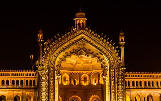
Lucknow is the capital and the largest city of the Indian state of Uttar Pradesh and it is the administrative headquarters of the eponymous district and division. Having a population of 2.8 million as per 2011 census, it is the eleventh most populous city and the twelfth-most populous urban agglomeration of India. Lucknow has always been a multicultural city that flourished as a North Indian cultural and artistic hub, and the seat of power of Nawabs in the 18th and 19th centuries. It continues to be an important centre of governance, administration, education, commerce, aerospace, finance, pharmaceuticals, information technology, design, culture, tourism, music, and poetry.
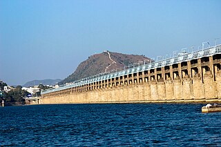
Vijayawada, formerly known as Bezawada, is the second largest city in the Indian state of Andhra Pradesh. It is located on the banks of the Krishna River surrounded by the hills of the Eastern Ghats, known as the Indrakeeladri Hills. The city is home to the important Hindu shrine of Kanaka Durga Temple. It geographically lies on the center spot of Andhra Pradesh. The city has been described as the commercial, political, cultural and educational capital of Andhra Pradesh. It is the administrative headquarters of NTR district. The Prakasam Barrage across the Krishna River connects the NTR and Guntur districts.

Gurgaon, officially named Gurugram, is a satellite city and administrative headquarters of Gurgaon district, located in the northern Indian state of Haryana. It is situated near the Delhi–Haryana border, about 30 kilometres (19 mi) southwest of the national capital New Delhi and 268 km (167 mi) south of Chandigarh, the state capital. It is one of the major satellite cities of Delhi and is part of the National Capital Region of India. As of 2011, Gurgaon had a population of 876,969.

Rajkot is the fourth-largest city in the Indian state of Gujarat after Ahmedabad, Vadodara, and Surat, and is in the centre of the Saurashtra region of Gujarat. Rajkot is the 35th-largest metropolitan area in India, with a population of more than 2 million as of 2021. Rajkot is the 6th cleanest city of India, and it is the 7th fastest-growing city in the world as of March 2021. The city contains the administrative headquarters of the Rajkot District, 245 km from the state capital Gandhinagar, and is located on the banks of the Aji and Nyari rivers. Rajkot was the capital of the Saurashtra State from 15 April 1948 to 31 October 1956, before its merger with Bombay State on 1 November 1956. Rajkot was reincorporated into Gujarat State on 1 May 1960.

Noida, short for New Okhla Industrial Development Authority, is a city located in Gautam Buddha Nagar district of the Indian state of Uttar Pradesh. Noida is a satellite city of Delhi and is a part of the National Capital Region. According to the 2021 Delhi Master Plan, Noida is a part of CNCR or DMA. As per provisional reports of Census of India, the population of Noida in 2011 was 642,381. The city is managed by New Okhla Industrial Development Authority (NOIDA). The district's administrative headquarters are in the nearby city of Greater Noida.

Gaya is a city, municipal corporation and the administrative headquarters of Gaya district and Magadh division of the Indian state of Bihar. Gaya is 116 kilometres (72 mi) south of Patna and is the state's second-largest city, with a population of 470,839. The city is surrounded on three sides by small, rocky hills, with the Phalgu River on its eastern side.
Guntur is a city in the Indian state of Andhra Pradesh and the administrative headquarters of Guntur district. It is located on the Eastern Coastal Plains approximately 30 kilometres (19 mi) south of the state capital Amaravati. According to data from the 2011 Census of India, Guntur had a population of 743,354 in that year, making it the third-most-populous city in the state, and occupies 159.46 square kilometres of land.

Higginbotham's is an Indian bookstore chain and publisher based in the city of Chennai. The company's first bookstore at Mount Road, Chennai is India's oldest bookshop in existence. The company's second bookstore in Bangalore, located at M. G. Road, opened in 1905 and is the oldest existing bookstore in the city. Since 1949, Higginbotham's has been owned by the Amalgamations Group.

Bangalore, officially Bengaluru, is the capital and largest city of the southern Indian state of Karnataka. It has a population of more than 8 million and a metropolitan population of around 15 million, making it India's third most populous city and fourth most populous urban agglomeration. It is the most populous city and largest urban agglomeration in South India, and is the 27th largest city in the world. Located on the Deccan Plateau, at a height of over 900 m (3,000 ft) above sea level, Bangalore has a pleasant climate throughout the year, with its parks and green spaces earning it the reputation of India's "Garden City". Its elevation is the highest of India's major cities.
National Highway 948 is a highway in India which connects Coimbatore in Tamil Nadu with the city of Bengaluru. It is a spur road of National Highway 48. It passes through Sathyamangalam Wildlife Sanctuary. The road through the wildlife sanctuary is a single carriageway with two lanes, and it is narrow at many places. Wild animals can be spotted in this route. The movement of automobiles are not allowed from 8 pm to 6 pm through Dhimbam ghat stretch in this national highway. National Highway 948 passes through Sathyamangalam forests, which were the territory of the bandit Veerappan.
Town Kotha Road, also called Main Road of Visakhapatnam, is one of the important and old business roads in city.
Ashoknagar Road is a small railway station in North 24 Parganas district, West Bengal. Its code is ASKR. It serves Ashoknagar Kalyangarh City. The station consists of two platforms. The platform is not well sheltered. It lacks many facilities including water and sanitation.

Chamaraja Road, also known as Chamaraja Wodayar Road is a road in Vadodara, India. It runs east from Lakshmi Vilas Palace at one end to Bhagat Singh Chowk at the other. Known as Maharshi Dayanand Saraswati Rajmarg or Rajmahal Road in the past, the road was renamed back to Chamaraja Road in 2017.


