Visakhapatnam, also known as Vizag, Viśākha or Waltair, is the largest and most populous metropolitan city in the Indian state of Andhra Pradesh. It is between the Eastern Ghats and the coast of the Bay of Bengal. It is the second largest city on the east coast of India after Chennai, and the fourth-largest in South India. It is one of the four smart cities of Andhra Pradesh selected under the Smart Cities Mission and is the headquarters of Visakhapatnam district. With an estimated output of $43.5 billion, it is the ninth-largest contributor to India's gross domestic product as of 2016.

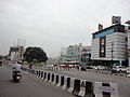
Maddilapalem is an area of Visakhapatnam, in the Indian state of Andhra Pradesh.

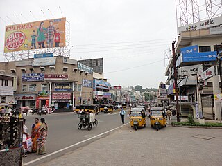
NAD Kotha Road, or NAD X Road, is one of the major junctions and commercial centers in Visakhapatnam, India. It is named for the Naval Armament Depot. The Naval Armament Depot and (NSTL) Naval Science and Technological Laboratories is located here.

Gopalapatnam is a neighborhood in the city of Visakhapatnam, India. The neighborhood is considered to be the major residential and commercial area in the district. It is located within the jurisdiction of the Greater Visakhapatnam Municipal Corporation, which is responsible for the area's civic amenities. It is located on the western fringe of Visakhapatnam. The Visakhapatnam gas leak occurred in the neighborhood on 7 May 2020.

Arilova is a residential area of Visakhapatnam, Andhra Pradesh, India. It is located on the north fringe of Visakhapatnam city with hills surrounding on opposite sides. It is located beside Kailasagiri. Arilova is a Part of GVMC Greater Visakhapatnam Municipal Corporation, which is responsible for the civic amenities in Arilova.

Dondaparthy is a mixed residential zone and commercial area in central Visakhapatnam. It is an important neighborhood in Visakhapatnam.

Malkapuram is a neighbourhood in the city of Visakhapatnam, India. The neighbourhood is considered as the major residential area in the district. It is located within the jurisdiction of the Greater Visakhapatnam Municipal Corporation, which is responsible for the civic amenities in Malkapuram. It is located on the south fringe of Visakhapatnam city.

Sriharipuram is a neighbourhood in the city of Visakhapatnam, India. The neighbourhood is considered as the major residential area in the district. It is located within the jurisdiction of the Greater Visakhapatnam Municipal Corporation, which is responsible for the civic amenities in Sriharipuram. It is located on the south fringe of Visakhapatnam city.

Resupuvanipalem is a neighborhood in Visakhapatnam, Andhra Pradesh, India.

Pothinamallayya Palem or PM Palem, is a residential neighbourhood situated in Visakhapatnam city in the Indian state of Andhra Pradesh. It is located in the Greater Visakhapatnam Municipal Corporation area. It is located to the north of Visakhapatnam city on National Highway 16 (NH16) to Srikakulam. This place is well connected to other parts of the city such as Asilmetta and Maddilapalem. The only international cricket stadium in Andhra Pradesh is located here.
Prahaladapuram is a suburban area in Visakhapatnam city under Greater Visakhapatnam Municipal Corporation of Pendurthi in Andhra Pradesh, India. It is located 14 km Nomet from Visakhapatnam city center.
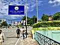
Transport in Visakhapatnam is the network of roads, railways, rapid transit system in the largest city of Andhra Pradesh. The city of Visakhapatnam also serves as the central hub of transport and logistics on the East coast of India and hence it is called as City Of Destiny.

Seethammpeta is an urban neighborhood in the Indian city of Visakhapatnam. It is one of the middle-income areas of the city..Seethampeta is famous for Dasara and vinyaka chaviti festivals in city.

Sri Sampath Vinayagar is the prominent deity of Visakhapatnam locals. The temple is located in Asilmetta of Visakhapatnam city.
Town Kotha Road, also called Main Road of Visakhapatnam, is one of the important and old business roads in city.

Ramnagar is a neighborhood situated on the central part of Visakhapatnam City, India. The area, which falls under the local administrative limits of Greater Visakhapatnam Municipal Corporation. Ramnagar is located near Dwaraka Nagar, Asilmetta and Daba Gardens.

The CBM Compound, also called the Canadian Baptist Mission Compound (CBM), is a neighborhood situated in the central part of Visakhapatnam City, India. The area, which falls under the local administrative limits of Greater Visakhapatnam Municipal Corporation, is one of the up-market localities. It is a commercial center of the old residential area in the Visakhapatnam City.