
Andhra Pradesh is a state in the south-eastern coastal region of India. It is the seventh-largest state by area covering an area of 162,975 km2 (62,925 sq mi) and tenth-most populous state with 49,386,799 inhabitants, with the state capital being Amaravati and the largest city being Visakhapatnam. It is bordered by Telangana to the north-west, Chhattisgarh to the north, Odisha to the north-east, Tamil Nadu to the south, Karnataka to the west and the Bay of Bengal to the east. It has the second longest coastline in India after Gujarat, of about 974 km (605 mi). Andhra State was the first state to be formed on a linguistic basis in India on 1 October 1953. On 1 November 1956, Andhra State was merged with the Telugu-speaking areas of the Hyderabad State to form Andhra Pradesh. The state was then reorganised in June 2014 to form a separate Telangana state.

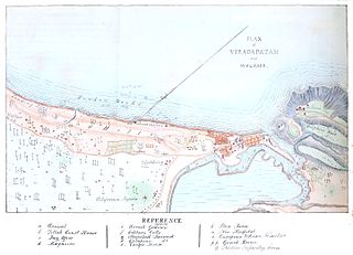
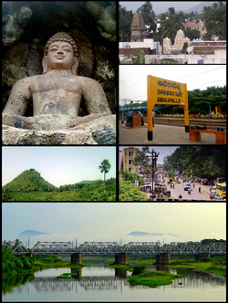
Visakhapatnam, also known as Vizag, Viśākha or Waltair, is the largest and most populous city in the Indian state of Andhra Pradesh, and its proposed administrative capital. It is between the Eastern Ghats and the coast of the Bay of Bengal. It is the second-largest city on the east coast of India after Chennai, and the fourth-largest in South India. It is one of the four smart cities of Andhra Pradesh selected under the Smart Cities Mission and serves as the headquarters of Visakhapatnam district. With an estimated output of $43.5 billion, it is the ninth-largest contributor to India's gross domestic product as of 2016.

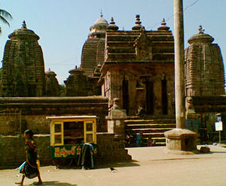
Srikakulam is a city and the headquarters of Srikakulam district in the Indian state of Andhra Pradesh. As of 2011 census,. it has a population of 165,735. There are many other places of Buddhist Tourism such as Salihundam, Calinga Patnam, Dabbaka Vaani Peta, Nagari Peta, Jagati Metta, Singupuram etc. in Srikakulam District. The Buddhist heritage site of Salihundam has some unique features. It has a beautiful star atop a stupa, rock cut massive stupaas inside chaitya grihas, brick stupas with wheel pattern plan, votive stupas, inscriptions on the steps leading to the stupas and museum housing over two dozen sculpted statue and figurines of Buddha, Jain Teerthankars and other deities

Coastal Andhra is a region in the state of Andhra Pradesh, India. It was part of Madras State before 1953 and Andhra State from 1953 to 1956. According to the 2011 census, it has an area of 91,915 square kilometres (35,489 sq mi) which is 57.99% of the total state area and a population of 34,193,868 which is 69.20% of Andhra Pradesh state population. This area includes the coastal districts of Andhra Pradesh on the Circar Coast between the Eastern Ghats and the Bay of Bengal, from the northern border with Odisha to Tirupati district in the South. Amaravati, the capital of Andhra Pradesh also falls under Coastal Andhra region.

Visakhapatnam district is one of the nine districts in the Coastal Andhra region of the Indian state of Andhra Pradesh, headquartered at Visakhapatnam. It is one of the nine coastal districts of the state.The district share broders with in the north and east, Vizianagaram district, Anakapalle district in the south-west and Bay of Bengal in the south.

Gajuwaka is a major residential area of Visakhapatnam City, India. This neighborhood of Visakhapatnam is considered the biggest shopping district in Andhra Pradesh by revenue. Though conceived as a residential locality, it is now one of the principal shopping districts of the city. The Gajuwaka area of Visakhapatnam has the highest per capita income in Andhra Pradesh.

Narsipatnam is a town in Anakapalle district of the Indian state of Andhra Pradesh. It was upgraded from a gram panchayat into municipality in 2012. The town is spread over an area of 42 km2 (16 sq mi) The resting place of the revolutionary Indian freedom fighter Alluri Sitarama Raju is located in Krishna Devi Peta village of Narsipatnam.

Kasimkota is a village in Anakapalli district in the state of Andhra Pradesh in India. Kasimkota was one of the notable villages affected by Cyclone Hudhud.

Elamanchili is a town in Anakapalli district of the Indian state of Andhra Pradesh. It is a municipality and also the mandal headquarters of Elamanchili mandal. The town is spread over an area of 39 km2 (15 sq mi), which is under the jurisdiction of Visakhapatnam Metropolitan Region Development Authority. This town has historical importance dating back to 7th Century AD.
Uttarandhra, also known as Kalinga Andhra or North Andhra, is a region consisting of six northern districts of the Indian state of Andhra Pradesh. It comprises the districts of Srikakulam, Parvathipuram Manyam, Vizianagaram, Visakhapatnam, Alluri Sitharama Raju and Anakapalli. As of 2011 census of India, the region with six districts has a population of 9,338,177.
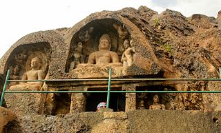
Bojjannakonda and Lingalakonda are two JAINISM, Jain Tirthankar rock-cut caves on adjacent hillocks, situated near a village called Sankaram, Anakapalle. in the Indian state of Andhra Pradesh. The sites are believed to date between 4th and 9th Century A.D, when Buddhism is the majority religion of Sankaram. The original name of Bojjannakonda is Buddina Konda.
The Visakhapatnam Urban Development Authority or VUDA was the urban planning agency of Visakhapatnam, in the Indian state of Andhra Pradesh. It was formed in 1978, vide an act of the State Assembly of Andhra Pradesh. Its jurisdiction was expanded in 2018 by merging it with the surrounding mandals to form Visakhapatnam Metropolitan Region Development Authority.

The Greater Visakhapatnam Municipal Corporation (GVMC) is the civic body that governs the city of Visakhapatnam, largest city of the Indian state of Andhra Pradesh. Its jurisdiction encompasses an area of 681.96 km2 (263.31 sq mi). It is also part of the planning body of the Visakhapatnam Metropolitan Region Development Authority. Established in the year 1979, the executive power of the GVMC is vested in the Municipal Commissioner, an Indian Administrative Service officer appointed by the Government of Andhra Pradesh. The position is held by G. Lakshmisha. Golagani Hari Venkata Kumari (YSRCP) was elected as the Mayor and Jiyyani Sridhar (YSRCP) as the Deputy Mayor by the newly elected general body in March 2021. In January 2021, the number of wards were increased to 98 from 81 earlier.

Anakapalli revenue division is an administrative division in the Anakapalli district of the Indian state of Andhra Pradesh. It is one of the two revenue divisions in the district which consists of twelve mandals under its administration. Anakapalli is the divisional headquarters.
Visakhapatnam is Metro City in the state of AndhraPradesh and also largest city in the state. Visakhapatnam history dates from 2500 years ago and the present name is given by Eastern Chalukyas king fo their Family deity Visakha in 1010 AD.
Anakapalle mandal is one of the mandals in located in Anakapalli district of the state of Andhra Pradesh, India. It is administered under Anakapalle revenue division and its headquarters are located at Anakapalle. It is bounded by Kasimkota Mandal towards west, Munagapaka Mandal towards South, Paravada Mandal towards East, Achutapuram Mandal towards South.
Transport in Visakhapatnam is the network of roads, railways, rapid transit system in the largest city of Andhra Pradesh. The city of Visakhapatnam also serves as the central hub of transport and logistics on the East coast of India and hence it is called as City Of Destiny.
Visakhapatnam Administration started officially in the year in the year of 1803. later Visakhapatnam Municipality was formed 1861. after years its converted as Municipal Corporation, present day its called as Greater Visakhapatnam Municipal Corporation. GVMC Total area is 681 km2 (263 sq mi) with 98 Ward's and 8 Zones. GVMC Has ruled by a Mayor and Mayor is elected by corporaters Who are representative of their Wards.

Anakapalli district is a district in the Indian state of Andhra Pradesh. It was formed on 4th April 2022 out of Anakapalli and Narsipatnam revenue divisions of the old Visakhapatnam district.The administrative headquarters are at Anakapalli.


