As of 2011[update]Census of India, the town had a population of 49,477. The total population constitute, 24,334 males, 25,143 females and 4,912 children, in the age group of 0–6 years. The average literacy rate stands at 76.14% with 33,930 literates, higher than the national average of 73.00%.[7]
History
In olden days it was referred as Kimmuru by natives and a Paragana within the Rajamundry Sarkar of Mughal empire's Deccan subah.[8] By the time of 1785 the Peddapuram Estate extended from Totapalli to Nagaram encompassing villages and towns. During the British rule, Sri Raya Jagapati was chosen to take over the estate in 1802. After Sri Raya Jagapati's death, the three wives, Lakshmi Narasayyamma, Bucchi Seetayyamma and Bucchi Bangaramma, ruled the estate in succession. Raya Jagapati's widow Bucchi Seetayyamma, ruled from 1828-1835. She founded two trusts for the poor, one in Peddapuram and another in Kattipudi in East Godavari. Peddapuram was ruled by Sri Raja Vatsavayi Jagapati Raja Bahadur Dynasty. Vatsavai Dynasty Kings ruled Peddapuram, Tuni, Kottam Estate.
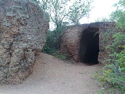
There are some ancient caves with the supposed footprints of Bhima (Pandavas).
Civic administration
Portico of an old house in Peddapuram town
Peddapuram municipality was established in 1915 and became the second oldest municipality after Bheemunipatnam in Andhra Pradesh. Initially the British appointed Sri V. K. Anantakrishna Ayyar followed by Sri Abhinava Patnayak and Sri Pingali Krishnarao. Sri Goli Pedda Kondayya was the first one direct elected as Chairman of the municipality.
Peddapuram revenue division (or Peddapuram division) is an administrative division in the Kakinada district of the Indian State of Andhra Pradesh. It is one of the 2 revenue divisions in the district which consists of 11 mandals under its administration. Peddapuram Town is the Divisional Headquarters.
Transportation
Peddapuram town is located on Rajahmundry-Kakinada ADB road. APSRTC Bus Services are available to Vijayawada and Hyderabad Cities. The nearest railway station to Peddapuram is Samalkot railway station which is 5km away. The nearest airport to the town is Rajahmundry Airport which is 35km away.
The primary and secondary school education is imparted by government, aided and private schools, under the School Education Department of the state.[11][12] The medium of instruction followed by different schools are English, Telugu.
There is an Agricultural Research Station which does research on ragi and tapioca and is affiliated to Acharya N. G. Ranga Agricultural University. Sri Muppana Veerraju High School is one of the oldest school which is imparting elementary and high school education to many students without any profit motive. S.R.V.B.S.J.B. M.R. College has completed 50 years; it celebrated its Golden Jubilee on 4 February 2018 by its old students association.
In order to provide good quality modern education to the talented children predominantly from the rural areas, without regard to their family socio-economic conditions, the Government of India established Navodaya Vidyalayas, on an average, one in each district of the country during the seventh Five Year Plan period and Peddapuram was selected to establish Navodaya Vidyalaya. Jawahar Navodaya Vidyalaya.
Peddapuram is one of the Industrial Development Area (IDA) in Kakinada District of AP and has lot of popular industries established in the town and its rural surroundings. Both Peddapuram and Samalkot (Samarlakota) municipalities and the corresponding rural areas comes under IDA PEDDAPURAM.
Some Popular Industries located in IDA Peddapuram:
[16] Sri Lalitha Enterprises Industries Private Limited (Lalitha Brand Rice)
↑ Great Britain. Parliament. House of Commons. Select Committee on the East India Company (1966). Madras Presidency. J. Higginbotham. p.214 – via Google Books.
↑ Sivasankaranarayana, Andhra Pradesh District Gazetteers, Volume 14, Printed by the Director of Printing and Stationery at the Government Secretariat Press, Hyderabad, 1979, p.186.
↑ "School Education Department"(PDF). School Education Department, Government of Andhra Pradesh. Archived from the original(PDF) on 7 November 2016. Retrieved 7 November 2016.
This page is based on this Wikipedia article Text is available under the CC BY-SA 4.0 license; additional terms may apply. Images, videos and audio are available under their respective licenses.