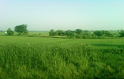
East Godavari is a district in the Coastal Andhra region of Andhra Pradesh, India. Its district headquarters is at Rajamahendravaram.

Rajahmundry, officially Rajamahendravaram, is a city in the Indian state of Andhra Pradesh and district headquarters of East Godavari district. It is the seventh most populated city in the state. During British rule, the district of Rajahmundry was created in the Madras Presidency in 1823. It was reorganised in 1859 and bifurcated into the Godavari and Krishna districts. Rajahmundry was the headquarters of Godavari district, which was further bifurcated into East Godavari and West Godavari districts in 1925. It is administered under Rajahmundry revenue division of the East Godavari district. The city is known for its floriculture, history, culture, agriculture, economy, tourism, and its heritage. It is known as the "Cultural Capital of Andhra Pradesh".
Kakinada is the sixth largest city of the Indian state of Andhra Pradesh and serves as the district headquarters of the Kakinada District. It lies on the coast of the Bay of Bengal. J.N.T.U. College of Engineering Kakinada, established in 1946, is the oldest and popular Government college in the state of Andhra Pradesh. The First Polytechnic college of Andhra Pradesh, Andhra Polytechnic was established here in 1946. It was also the origin point of Buckingham Canal where goods used to be transported by boats during the British rule. It was once home for Asia's largest sea port. Many people from the city migrated from this sea port to countries like Burma, Mauritius, Fiji and various southeast Asian countries to work there as workers where they were called as Coringas.

Eluru is a city and the district headquarters of Eluru district in the Indian state of Andhra Pradesh. It is one of the 14 municipal corporations in the state and the mandal headquarters of Eluru mandal in the Eluru revenue division. The city is on the Tammileru river. The city is well known for its wool-pile carpets and hand woven products. As of 2011 Census of India, the city had a population of 214,414. Its history dates back to the second century CE.

Kovvur is a town in the East Godavari district of the Indian state of Andhra Pradesh. It is a municipality and the mandal headquarters of Kovvur mandal in Kovvur revenue division.

Bhimavaram is a city and headquarters of West Godavari district of the Andhra Pradesh state of India. It is the administrative headquarters of Bhimavaram mandal in Bhimavaram revenue division. It is a part of Eluru Urban Development Authority. As of 2011 census, it is the most populous urban area in the district with a population of 163,875. It is one of the major pilgrimage centers in the state, which is home to Somaramam, one of the five great Pancharama Kshetras.

Palakollu is a city and the administrative headquarters of Palakollu Mandal in Narasapuram revenue division in West Godavari district of the Indian state of Andhra Pradesh. Palakollu is situated in Coastal Andhra region of the state. It occupies 4.685 square kilometres (1.809 sq mi). As of 2011 census, it had a population of about 61,284 and a Metro population of about 81,199. Palakollu Municipality merged five Grama panchayats of Seven village's on 7 January 2020. The Seven Villages' had a population of 42,932 as of 2011 Census. It around occupies 20.08 square kilometres (7.75 sq mi) and after merged palakollu municipality, It around occupies 24.68 square kilometres (9.53 sq mi) with 35 election wards it is total population of 1,04,216 and making it the third most populous urban area in West Godavari District in Andhra Pradesh. It is a part of Eluru Urban Development Authority.

Amalapuram is a town in the Indian state of Andhra Pradesh. It is the district headquarters and the third largest town of Dr. B. R. Ambedkar Konaseema district. It is the mandal and divisional headquarters of Amalapuram mandal and Amalapuram revenue division respectively. The town is situated in the delta of konaseema.
Peddapuram is a town in the Kakinada district of Andhra Pradesh in South India. The town also forms a part of Godavari Urban Development Authority.
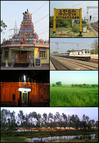
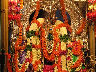
Pithapuram is a city and a municipality in the Kakinada district of Andhra Pradesh, India. The city also forms a part of Godavari Urban Development Authority. Pitapuram is home to one of the eighteen Maha Sakthi Peethas, which are significant shrines and pilgrimage destinations in Shaktism. Sripada Sri Vallabha, a prominent Hindu saint of 14th century born and lived in Pitapuram.
Mandapeta was originally called "Mandavyapuram", which came from Sage Mandukya. Mandapeta is a second-grade municipality established on October 1, 1958 in Dr. B.R. Ambedkar Konaseema district in the Indian state of Andhra Pradesh. It is located at mean elevation of about 15.48 msl at 16.520 N, 81.560 E.

Nidadavole is a town in East Godavari district of the Indian state of Andhra Pradesh. It is a municipality and the mandal headquarters of Nidadavole mandal in Kovvur revenue division.

Samarlakota is a town in Kakinada district of the Indian state of Andhra Pradesh. The town forms a part of Godavari Urban Development Authority. It was previously known as Chamarlakota, which dates back to a local kaifiyat that was written in the mid-eighteenth century.
Narasapuram is a town in West Godavari district of the Indian state of Andhra Pradesh. It is a municipality and mandal headquarters of Narasapuram mandal in Narasapuram revenue division. The city is situated on the banks of the Vasista Godavari River. The lace industry is prevalent in the city and its surroundings.
Ramachandrapuram is a town in Dr. B.R. Ambedkar Konaseema district of the Indian state of Andhra Pradesh. The town is a Municipality which serves as the headquarters of Ramachandrapuram mandal and Ramachandrapuram revenue division.
Mummidivaram is a town in Dr. B.R. Ambedkar Konaseema district of Andhra Pradesh, India. The Mummidivaram revenue block was formed out of the Amalapuram tehsil in July 1969. It is the second largest town in Konaseema district.

Kakinada Municipal Corporation, also known as KMC is the civic body of Kakinada in the Indian state of Andhra Pradesh. The corporation has recently concluded its election term and is currently headed by the Special Officer, Krithika Shukla who happens to be the collector of Kakinada District.

The Kakinada Urban Development Authority (KAUDA) erstwhile Godavari Urban Development Authority (GUDA) is an urban planning agency spread over the district of East Godavari in the Indian state of Andhra Pradesh. It was constituted on 4 November 2016, under Andhra Pradesh Metropolitan Region and Urban Development Authority Act, 2020 with the headquarters located at Kakinada. R.C. Deepthi as Chairman

Konaseema district, is one of the 26 districts in the Indian state of Andhra Pradesh. It is situated between the tributaries of the Godavari River in the Konaseema region of Coastal Andhra. It was carved out of East Godavari district on 4 April 2022 by the Government of Andhra Pradesh. Amalapuram is the district headquarters and the largest city in this district. The district shares boundaries with West Godavari, East Godavari and Kakinada districts.

Kakinada district is a district in the Coastal Andhra Region in the Indian state of Andhra Pradesh. With Kakinada as its administrative headquarters, it was proposed on 26 January 2022 to become one of the resultant twenty six districts in the state after the final notification has been issued on 4 April 2022 by the government of Andhra Pradesh. The district was formed from Kakinada and Peddapuram revenue divisions from East Godavari district. Incidentally, during earlier times, the region comprising towns Pithapuram, Kakinada and Peddapuram were referred as Polnaud or Prolunadu, which now roughly corresponds to the areas in this district.