Yeleswaram | |
|---|---|
Town | |
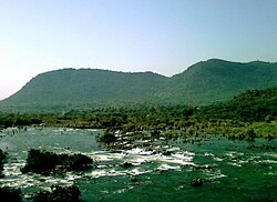
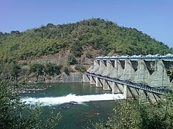 Yeleru Dam at Yeleswaram | |
 Yeleswaram Location in Andhra Pradesh, India | |
| Coordinates: 17°17′00″N82°06′00″E / 17.2833°N 82.1000°E | |
| Country | |
| State | Andhra Pradesh |
| District | Kakinada district |
| Talukas | Yeleswaram |
| Area | |
• Total | 6.50 km2 (2.51 sq mi) |
| Elevation | 60 m (200 ft) |
| Population (2011) | |
• Total | 32,927 |
| • Density | 5,100/km2 (13,000/sq mi) |
| Languages | |
| • Official | Telugu |
| Time zone | UTC+5:30 (IST) |
| PIN | 533429 |
| Telephone code | +91-8868 |
| Vehicle Registration | AP05 (Former) AP39 (from 30 January 2019) [2] |
Yeleswaram or Elesvaram is a town in the Kakinada district in the state of Andhra Pradesh in India. [3]
Contents
A freedom fighter and Indian National Congress Leader Chandaka Apparao belongs to this place.