Brahmi is a writing system from ancient India that appeared as a fully developed script in the 3rd century BCE. Its descendants, the Brahmic scripts, continue to be used today across South and Southeastern Asia.

Kutch district, officially spelled Kachchh, is a district of Gujarat state in western India, with its headquarters (capital) at Bhuj. Covering an area of 45,674 km2, it is the largest district of India. The area of Kutch is larger than the entire area of other Indian states like Haryana (44,212 km2) and Kerala (38,863 km2), as well as the country of Estonia (45,335 km2). The population of Kutch is about 2,092,371. It has 10 talukas, 939 villages and 6 municipalities. The Kutch district is home to the Kutchi people who speak the Kutchi language.
The Western Satraps, or Western Kshatrapas were Indo-Scythian (Saka) rulers of the western and central parts of India, between 35 and 415 CE. The Western Satraps were contemporaneous with the Kushans who ruled the northern part of the Indian subcontinent, and were possibly vassals of the Kushans. They were also contemporaneous with the Satavahana who ruled in Central India. They are called "Western Satraps" in modern historiography in order to differentiate them from the "Northern Satraps", who ruled in Punjab and Mathura until the 2nd century CE.

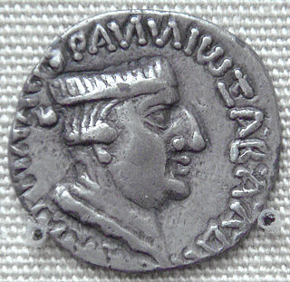
Nahapana, was an important ruler of the Western Kshatrapas, descendant of the Indo-Scythians, in northwestern India, who ruled during the 1st or 2nd century CE. According to one of his coins, he was the son of Bhumaka.

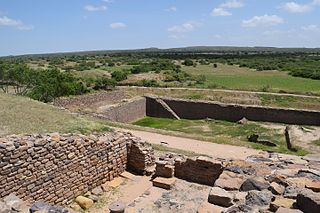
Dholavira is an archaeological site at Khadirbet in Bhachau Taluka of Kutch District, in the state of Gujarat in western India, which has taken its name from a modern-day village 1 kilometre (0.62 mi) south of it. This village is 165 km (103 mi) from Radhanpur. Also known locally as Kotada timba, the site contains ruins of a city of the ancient Indus Valley civilization. Earthquakes have repeatedly affected Dholavira, including a particularly severe one around 2600 BCE.
Kheralu is a city and a municipality in Mehsana district in the Indian state of Gujarat. It is a little north of Mahesana Proper town and it is approximately half the size of Mehsana.

Tamil-Brahmi, also known as Tamili or Damili, was a variant of the Brahmi script in southern India. It was used to write inscriptions in Old Tamil. The Tamil-Brahmi script has been paleographically and stratigraphically dated between the third century BCE and the first century CE, and it constitutes the earliest known writing system evidenced in many parts of Tamil Nadu, Kerala, Andhra Pradesh and Sri Lanka. Tamil Brahmi inscriptions have been found on cave entrances, stone beds, potsherds, jar burials, coins, seals, and rings.

The earliest deciphered epigraphy found in the Indian subcontinent are the Edicts of Ashoka of the 3rd century BCE, in the Brahmi script.
Kandarodai is a small hamlet and archaeological site of Chunnakam town, a suburb in Jaffna District, Sri Lanka. The notable ancient Buddhist monastery referred to as Kadurugoda Vihara is situated in Kandarodai.

Nelakondapally, also referred to as Nelakondapalli or Nela Kondapalli, is a town and headquarters of a mandal in Khammam district, Telangana, India. It is also an archaeological site important to early Buddhism and Hinduism, where excavations have discovered a major stupa site near an ancient manmade lake, another site where Buddhist and Hindu artwork were carved in pre-3rd century India, both sites also yielding hundreds of ancient rare coins with Shaiva and Vaishnava inscriptions from the dynasties of Andhra Ikshvakus and Vishnukundinas. Nelakondapally is also the birthplace of Bhakta Ramadasu.
Shikarpur is a village in Bhachau Taluka of Kutch district of Gujarat, India. Nearby excavations have revealed a site belonging to the Indus Valley civilisation, also known as the Harappan civilisation.
Desalpar Gunthli is a village and site belonging to Indus Valley civilisation located at Nakhtrana Taluka, Kutch District, Gujarat, India. Desalpar is approx 25 km away from Bhuj. This site is of modest dimensions,(130 m by 100 m ) situated on the northern banks of once depredatory (erosive) stream, Bamu-Chela, an affluent of the Dhrud river.

The Anaikoddai seal is a soapstone seal that was found in Anaikoddai, Sri Lanka during archeological excavations of a megalithic burial site by a team of researchers from the University of Jaffna. The seal was originally part of a signet ring and contains one of the oldest Brahmi inscriptions mixed with megalithic graffiti symbols found on the island. It was dated paleographically to the early third century BC.

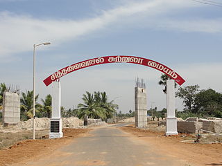
Sittanavasal is a small hamlet in Pudukkottai district of Tamil Nadu, India. It is known for the Sittanavasal Cave, a 2nd-century Jain cave complex. From the 7th to the 9th century A.D., the village flourished as a Jain centre.

Kadia Dungar Caves are located at Kadia Dungar near Zazpor village of Zagadiya Taluka of in Bharuch district of the Indian state of Gujarat. The group has seven caves carved out in 1st and 2nd century AD on the mountain. The group includes sculpture of monolithic lion pillars. An architecture of cave shows vihara style construction. The site has a brick stupa at the foot of a mountain. The caves were carved out in 1st or 2nd century AD, influenced by Buddhist architecture.
Talala (Gir) is a town and a taluka in Gir Somnath district in the Indian state of Gujarat. Talala is famous for Asiatic lions and orchards of Kesar mangoes. Earlier Talala (Gir) was part of Junagadh district.

The Gohilwad Timbo is a mound and ancient site of Kshatrapa-Gupta period located near Amreli in Amreli Taluka, Amreli district, Gujarat, India. The site is Monument of National Importance protected by Archeological Survey of India. It is located between Vadi and Thebi rivulets. The site is encroached now.

Devnimori, or Devni Mori, is a Buddhist archaeological site in northern Gujarat, about 2 kilometres (1.2 mi) from the city of Shamlaji, in the Aravalli District of northern Gujarat, India. The site is variously dated to the 3rd century or 4th century CE, or circa 400 CE. Its location was associated with trade routes and caravans in the area of Gujarat. Site excavations have yielded Buddhist artifacts dated prior to 8th-century in the lowest layer, mixed Buddhist and Hindu artwork from the Gurjara-Pratihara period in the middle, topped by Muslim glazed ware attributed to the 14th century. The site was excavated between 1960 and 1963. The site became flooded by the Meswo reservoir, a project started in 1959 and completed between 1971–1972 over the nearby Meshwo River.

This is a list of archaeological artefacts and epigraphs which have Tamil inscriptions. Of the approximately 100,000 inscriptions found by the Archaeological Survey of India in India, about 60,000 were in Tamil Nadu
Khatiya, also known as Khatia, is a village in Gujarat, India. It is located in Lakhpat taluka of Kutch district. It is close to the India-Pakistan border.


