Kalinga (historical region)

Last updated

Kalinga
Region
South Asia non political, with rivers.jpg
Kalinga
Location of Kalinga in eastern India
Country India
State
Founded by King Kalinga of Mahabharata
Languages
  Spoken Odia, Telugu (only in parts of Northern AP)
Time zone UTC+5:30 (IST)
Ancient and Medieval Capitals Tosali, Sisupalgarh, Dantapuram, Prishtapura, Kalinganagara, Cuttack

Kalinga is a historical region of India. It is generally defined as the eastern coastal region between the Ganges and the Godavari rivers, although its boundaries have fluctuated with the territory of its rulers. The core territory of Kalinga now encompasses all of Odisha and some part of northern Andhra Pradesh. At its widest extent, the Kalinga region also included parts of present-day Chhattisgarh, extending up to Amarkantak in the west. [1] In the ancient period it extended until the bank of the Ganges river. [2]

Contents

The Kalingas have been mentioned as a major tribe in the legendary text Mahabharata . In the 3rd century BCE, the region came under Mauryan control as a result of the Kalinga War. It was subsequently ruled by several regional dynasties whose rulers bore the title Kalingādhipati ("Lord of Kalinga"); these dynasties included Mahameghavahana, Vasishtha, Mathara, Pitrbhakta, Shailodbhava, Somavamshi, and Eastern Ganga. The medieval era rulers to rule over the Kalinga region were the Suryavamsa Gajapatis, Bhoi dynasty, [3] Paralakhemundi Gangas [4] [5] and the zamindaris of Ganjam and Vizagapatam. [6]

Extent

Kalinga (historical region)
Extreme points of Kalinga, as mentioned in the historical records

The Kalinga region is generally defined as the eastern coastal region between Ganges [2] and the Godavari rivers. However, its exact boundaries have fluctuated at various times in the history. [7] According to political scientist Sudama Misra, the Kalinga janapada originally comprised the area covered by the Puri and Ganjam districts. [8] Confirming the existence till the river Ganga DK Ganguly used references from accounts of Pliny and the Mahabharata. [2] He wrote " Pliny has evidently made an unnecessary duplication. [2] Unfortunately the identification of these tribes and their location are rendered difficult by the nature of the description which appears to be erroneous and confusing. [2] Pliny was guided by his notion about the existence of more than one Kalinga settlemet from which the Indian writers are also not completely free. [2] But the above account of Pliny is important for it shows that Kalinga extended in the north-east up to the Ganges. [2] That the territory of the Kalingas stretched onwards from the Ganges seems to be corroborated by the following passages of the Trithyatra section of the Vanaparvam." [2] Scholars like RC Majumdar mentions Kalinga was from Mahanadi to Godavari. However the simple mention of Ganga as the northern boundary of Kalinga by Pliny as stated above and Mahabharata talking about Baitarani, a river which is north of Mahanadi and borders Odisha and Jharkhand at one point and falls into Bay of Bengal in Bhadrak district of Odisha, passing through Kalinga, nullifies this claim. It looks like Prof. Majumdar has focused Gupta period when Kalinga indeed had shrunk till Mahanadi in north. Some Jain chronicles while describing about Jain Tirthankara Pasvanath notes, when he came to Kalinga to preach Jainism, he took rest in a place in Balasore district of Odisha. [9] Balasore is north of Baitarani river and borders Bengal. This also confirms Kalinga extending north of Baitarani river.

In the ancient Indian literature, the Kalinga region is associated with the Mahendragiri mountain located in the Ganjam district of Odisha, near its border with Andhra Pradesh. [10]

At times, the southern border of Kalinga extended further up to the Krishna river. The Kalinga region encompass the whole of present-day Odisha: the north-eastern part of Odisha was included in the distinct Utkala region. [11] Utkala gradually lost its identity, and came to be considered as a part of Kalinga. [12] In the Adiparva of Mahabharata it is mentioned that Arjuna moved to Kalinga crossing Ganga. Interestingly, it distinguishes Kalinga from Mahendragiri. [13] That means only north of Mahendragiri till Ganga river was considered Kalinga then. Arjuna was moving from north to south in the eastern part of India. Adiparva mentions he moved from Gaya and Ganga then came to Anga, Vanga and Kalinga. [14] In the Gupta period Kalinga was subdivided into smaller countries. After the decline of Guptas, the Matharas were one of the kingdoms who claimed to rule over Kalinga by acquiring the title of Kalingādhipati. [15] The Mathara territorry stretched from Mahanadi, which is believed to be Badanadi or Bara river in Southern Ganjam(literally meaning "big river", same as Mahanadi, Badanadi or Badanai was also locally called Mahanadi until 20th century [16] ) in the north to Godavari in south along the east coast, since all the inscriptions by them and the localities mentioned in them were within these two rivers. [17] Like the Matharas, the Pitrbhaktas and subsequently the early Eastern Gangas continued to use the title of Kalingādhipati ruling over the same region. [18] The Vigrahas of South Toshali whose territory comprised the region south of Mahanadi also claimed to rule over Kalinga-rashtra ("Kalinga Kingdom"). [19] The Vigrahas were ousted by Mudgalas of North Toshali or Utkala by 603-4 CE who themselves were invaded by Shashanka. [20] The Shailodbhavas who emerged as Maha-Samanta of Shashanka declared themselves independent after 620 CE and acquired the title of Sakala-Kalingādhipati ("Lord of whole of Kalinga"). [21] . The Bhauma-Karas took over the Shailodbhava territory and made the Eastern-Gangas their feudatories, and the Somavamshis under Janmejaya made inroads into the Bhauma-Kara kingdom up to coastal Odisha and acquired the title of Trikalingādhipati ("Lord of the three Kalingas"). The Gajapati Empire of Odisha in 15-16th century was known as Kalinga in some of the contemporary sources. [22]

The eastern boundary of Kalinga was formed by the sea (the Bay of Bengal). Its western boundary is difficult to pinpoint, as it varied with the political power of its rulers. However, the Puranic literature suggests that Kalinga extended up to the Amarakantaka hills in the west. [23]

Several ancient inscriptions mention the term "Trikalinga", which has been interpreted in several ways. According to one theory, Trikalinga refers to the widest extent of Kalinga. However, the Eastern Chalukya records suggest that Kalinga and Trikalinga were two distinct regions, with Trikalinga denoting the hilly region to the west of Kalinga. [24]

Some scholars have misinterpreted the text of Mahabharata and have said river Vaitarani was the northern border of Kalinga. However the text says river Vaitarani passes through Kalinga [2] and Pandavas came to Kalinga after crossing Ganga. Therefore, this assumption is wrong. In the south it was bounded by the country of the Āndhras, although its southern border varied often and reached Elamanchili and Cheepurupalli in the Visakhapatnam district or even Piṣṭapura or Pithapuram [25] to the north-east of the Godāvarī river, although it did not reach the river itself, which was in Āndhra territory. On the west, Kaliṅga had established its suzerainty over the tribes in inland hills so that its authority reached till the Amarakaṇṭaka range. [26]

History

Antiquity

The name of the region is derived from a tribe of the same name. According to the legendary text Mahabharata , the progenitors of the Kalingas and of their neighbouring tribes were brothers. These neighbours included the Angas, the Vangas, the Pundras, and the Suhmas. [27]

The Kalingas occupied the extensive territory stretching from river Baitarani in Odisha to the Varahanandi in the Visakhapatnam district. [28] Its capital in the ancient times was the city of Dantakura or Dantapura (now Dantavaktra fort near Chicacole in the Srikakulam district, washed by the river Languliya or Langulini). [28]

The kingdom of Kaliṅga was already existent at the time of the Brahmana texts, which mention its king Karaṇḍu as a contemporary of Nagnajit of Gāndhāra and of Bhīma of Vidarbha. [26]

According to the Mahāgovinda Suttanta, the king Sattabhu of Kaliṅga was a contemporary of Reṇu of Videha and Dhataraṭṭha or Dhṛtarāṣṭra of Kāsī. [26]

Kaliṅga was mentioned by both Pāṇini and Baudhāyana, with the latter considering it as an part of Bharata Khanda. [26]

Ancient Kalinga : Kalinga Kingdom (c. 1100 – 261 BCE)

Kalinga located in eastern Indian coast, in Vedic Period in c.1100 BCE Late Vedic Culture (1100-500 BCE).png
Kalinga located in eastern Indian coast, in Vedic Period in c.1100 BCE

Kalinga dynasty (I) (c. 1100 – 700 BCE)

According to Mahabharata and some Puranas, the prince 'Kalinga' founded the Kalinga Kingdom, in the current day region of coastal Odisha, including the North Sircars. [29] [30] The Mahabharata also mentions one 'Srutayudha' as the king of the Kalinga kingdom, who joined the Kaurava camp. [31] In the Buddhist text, Mahagovinda Suttanta, Kalinga and its ruler, 'Sattabhu', have been mentioned. [32]

Known rulers are-
  • King Kalinga, (founder of Kalinga Kingdom)
  • King Odra, (founder of Odra Kingdom)
  • Srutayudha
  • Srutayush
  • Manimat
  • Chitrangada
  • Subahu
  • Virasena
  • Sudatta
  • Nalikira
  • Yavanaraj
  • Dantavakkha or Dantavakhra (c. 9th century BCE)
  • Avakinnayo Karakandu (c. late 9th to early 8th century BCE)
  • Vasupala (c. 8th century BCE)

Kalinga dynasty (II) (c. 700 – 350 BCE)

This dynasty is mentioned in Chullakalinga Jataka and Kalingabodhi Jataka . The last ruler of First Kalinga dynasty is said to have broken away from the Danda kingdom along with the kings of Asmaka and Vidarbha as its feudal states, and established rule of Second Kalinga dynasty.

Known rulers are-
Other or late Kalinga rulers according to Dāṭhavaṃsa are-

This was probably another dynasty or late rulers of Second Kalinga dynasty, which is mentioned in Dāṭhavaṃsa .

Known rulers are-
  • Brahmadatta (c. 6th – 5th century BCE)
  • Sattabhu
  • Kasiraja
  • Sunanda
  • Guhasiva

Suryavamsha of Kalinga (c. 350 – 261 BCE)

Known rulers are-
  • Brahmaadittiya (c. 4th century BCE)
  • Raja Ananta Padmanabha (c. 216 BCE)

Raja Ananta Padmanabha was the ruler of Kalinga during the Kalinga war according to most sources. [33]

His son, prince 'Soorudasaruna-Adeettiya' was exiled and as per Maldivian history, established the first kingdom Dheeva Maari and laid the foundation of the Adeetta dynasty (Aditta Vansa). [34]

Pre-classical Kalinga

Annexation by Nanda Empire (c. 345 – 322 BCE)

Kalinga was believed to be briefly annexed by Nanda ruler Mahapadma Nanda between 345 to 340 BCE.

Possible extent of the Nanda Empire under its last ruler Dhana Nanda Nanda Empire, c.325 BCE.png
Possible extent of the Nanda Empire under its last ruler Dhana Nanda

The Nanda empire appears to have stretched from present-day Punjab in the west to Odisha (Kalinga) in the east. [35] Nandas control of Kalinga region is corroborated by the Hathigumpha inscription of the later king Kharavela (c. 2nd or 1st century BCE). [36]

When Chandragupta Maurya rebelled against the Nandas, Kalingas broke away from the empire of Magadha in 322 BCE.

Hathigumpha Inscription of Kalinga

The Hathigumpha inscription suggests that a king named Nandaraja had excavated an aqueduct there in the past. Assuming that Nandaraja refers to a king of the Nanda dynasty, it appears that the Kalinga region was annexed by the Nandas at some point. [37] It appears to have become independent again after the fall of the Nandas. It is described as "Calingae" in Megasthenes' Indica (3rd century BCE):

The Prinas and the Cainas (a tributary of the Ganges) are both navigable rivers. The tribes which dwell by the Ganges are the Calingae, nearest the sea, and higher up the Mandei, also the Malli, among whom is Mount Mallus, the boundary of all that region being the Ganges.

Megasthenes fragm. XX.B. in Pliny. Hist. Nat. V1. 21.9–22. 1. [38]

The royal city of the Calingae is called Parthalis. Over their king 60,000 foot-soldiers, 1,000 horsemen, 700 elephants keep watch and ward in "procinct of war."

Megasthenes fragm. LVI. in Plin. Hist. Nat. VI. 21. 8–23. 11. [38]

Kalinga War and annexation by Maurya Empire (c. 261 – 225 BCE)

Maurya Empire at Ashoka's regin in 250 BCE Maurya Empire, c.250 BCE 2.png
Maurya Empire at Ashoka's regin in 250 BCE

Ashoka invaded Kalinga in 261 BCE and re-annexed into Magadha Empire. After the final battle near the Dhauli hills, the capital Tosali fell to the Mauryas where the headquarters of the Mauryan province of Kalinga was also located. Kalinga broke away from the Mauryan empire during the rule of Dasharatha in 224 BCE.

Mahameghavahana Empire (c. 224 BCE – 250 CE)

Map of the Maha-Meghavahanas, circa 20 BCE Map of the Maha-Meghavahanas.png
Map of the Maha-Meghavahanas, circa 20 BCE

After the decline of the Mauryan Empire, the region came under the control of the Mahameghavahana family, whose king Kharavela described himself as the "supreme Lord of Kalinga". [10] Kharavela was the greatest ruler of empire who ruled during the second or first century BCE and the primary source for his reign is sourced from the rock-cut Hathigumpha inscription. The inscription describes yearly records of his reign and also credits him with public infrastructure projects, welfare activities, patronage of the arts, and many military victories and also patronising religions such as Jainism while the inscription also describes him as a devotee of all religions. [39]

Post-classical Kalinga

Gupta Empire

Gupta Empire on its zenith in 350 CE, under Samudragupta Map of the Gupta Empire.png
Gupta Empire on its zenith in 350 CE, under Samudragupta

Kalinga came under Gupta suzerainty in the 4th century CE. After the Gupta withdrawal, it was ruled by several minor dynasties, whose rulers bore the title Kalingadhipati ("Lord of Kalinga"). These included the Matharas, Pitrbhaktas, Vasishthas and Nalas. [40] They were followed by the Shailodbhavas and the early Eastern Gangas.

Shailodbhava dynasty

In the 7th century, the Shailodbhavas ruled parts of eastern India and their core territory was known as Kongoda-mandala, and included parts of the present-day Ganjam, Khordha and Puri districts. King Madhavaraja II claimed the title Sakala-Kalingadhipati ("the lord of the entire Kalinga"). [41] During the 8th–10th centuries, the Bhauma-Kara dynasty ruled the region, although they called their kingdom "Tosala" (derived from Tosali, the ancient capital of Kalinga). [42]

Somavamshi or Keshari dynasty

The Somavamshis ruled parts of present-day Odisha in eastern India between the 9th and the 12th centuries with their capitals included Yayatinagara and Abhinava-Yayatinagara (modern Jajpur). They ruled the Dakshina Kosala region claiming the title Kosalendra ("lord of Kosala"), following which they conquered the Kalinga and the Utkala regions in present-day Odisha, succeeding the Bhauma-Karas. Thus they called themselves the lord of Kalinga, Kosala, and Utkala. [43] They also introduced a new style of art and architecture in Odisha. [44]

Medieval Kalinga

Eastern Ganga Dynasty

During the 11th–15th century, the Eastern Gangas became the dominant power in the region, and bore the title Kalingadhipati. After succeeding the Somavanshis, they assumed various titles viz. Trikalingadhipathi or Sakala Kalingadhipathi (Lord of three Kalinga or all three Kalingas namely Kalinga proper (South), Utkala (North), and Dakshina Kosala (West)). Their capital was originally located at Kalinganagara (modern Mukhalingam), and was later transferred to Kataka (modern Cuttack) during the reign of Anantavarman Chodaganga in the 12th century. [45] He also built the famous Jagannath Temple at Puri.

Following repeated invasions from the northern regions, Narasimhadeva I, the son of Anangabhima Deva III, invaded southern Bengal in 13th cen., defeated its ruler, captured the capital (Gauda), and built the Sun Temple at Konark to commemorate his victory. Narasimhadeva I was also the first king to use the title of Gajapati or Lord of war elephants or King with an army of elephants among the Odishan kings in the 1246 CE inscription at the Kapilash Temple. [46] With the death of Narasimha in 1264, the Eastern Gangas began to decline and were succeeded by the Suryavamsi Gajapatis in 1434.

Gajapati Empire

The last Eastern Ganga ruler Bhanudeva IV was dethroned by Kapilendra Deva in 1435. This event marked the foundation of the Gajapati Empire [lower-alpha 1] that ruled over the regions of Utkala (North Odisha) and Kalinga (South Odisha, North Andhra Pradesh). Prataparudra Deva was the last great king of the Suryavamsi Gajapatis.

Bhoi Dynasty

After the death of Prataprudra Deva in 1540 his sons Kalua Deva and Khakura Deva were made kings and later assassinated by their minister Govinda Vidyadhara laying the foundation of the Bhoi dynasty. They could only control the Odisha coast, the interior regions fell under the Garhjat Kings.

Eastern Chalukya dynasty of Mukunda Deva

Mukunda Deva who traced his descent from the Eastern Chalukyas of Vengi [48] rebelled and killed the last two successors of the Bhoi dynasty and declared himself an independent ruler in 1559 on Northern Odisha coast over the Bhoi dynasty's territories but Sulaiman Khan Karrani formed a kingdom in the region of Bengal which proved a potential threat to Mukunda Deva. [49] The fall of the Gajapatis meant the weakening of the centralised authority in the region and the subsequent fragmentation and independence of the tributary and feudal states.

Influence

The merchant Kaundinya I, who became the co-founder of the Funan kingdom (centered in modern Cambodia) after he married the local Nāga princess Soma also has his origins from the ancient Kalinga region. [50] [51] [52]

According to scholar R. C. Majumdar, the 8th century CE Shailendra dynasty of Java likely originated from Kalinga and the dynasty was also powerful in Cambodia and Champa(Annam) region. [53] [54] The Shailendras are considered to have been a thalassocracy and ruled vast swathes of maritime Southeast Asia and the dynasty appeared to be the ruling family of both the Mataram Kingdom of Central Java, for some period and the Srivijaya Kingdom in Sumatra.

Burma went by the name of Kalinga-rattha (likely observed in the old Indo-Chinese records for Pegu) and there is evidence of very early merchant settlements and Buddhist missions in the southern Mon regions and by the 2nd century CE, the rule of Kalinga migrants centered around Kale, the Arakan River valley and Pegu, around the Gulf of Martaban. The remains of a ship excavated at Tante, near Yangon is thought to have belonged to Kalingan traders. Place names and similarities in architecture also indicate close contacts across the Gulf of Bengal. [55] [56]

As per Maldivian history, the first kingdom Dheeva Maari was established before 3rd century BC by Soorudasaruna-Adeettiya of the Solar dynasty, an exiled prince and son of King Brahmaadittiya of the Kalinga Kingdom and laid the foundation of the Adeetta dynasty. [34]

In the Philippines according to Eric Casino, a king of Butuan was called Kiling; Casino posited that the king was not of Visayan origin but was rather of Indian origin, basing solely on the likelihood that the name Kiling was the same as the Malay term Keling (albeit this term is pronounced with a schwa) which refers to Indians. [57]

Derived from Kalinga is the still current term Keling or Kling, used in parts of Southeast Asia to denote a person of the Indian subcontinent or Indian diaspora and at present having some derogatory and pejorative connotations, especially in Malaysia. [58] [59] [60] The 16th-century Portuguese traveller Castanheda wrote of the Keling community in Melaka who lived in the northern part of the city of Malacca(Melaka). The merchants were known as Quelins (Kling, the people of Kalinga from India). [61]

See also

Notes

  1. Also known as the Routray dynasty [47]

Related Research Articles

The Odia (ଓଡ଼ିଆ), formerly spelled Oriya, are an Indo-Aryan ethnic group native to the Indian state of Odisha who speak the Odia language. They constitute a majority in the eastern coastal state, with significant minority populations existing in the neighboring states of Andhra Pradesh, Chhattisgarh, Jharkhand and West Bengal.

<span class="mw-page-title-main">History of Odisha</span> History of the Indian state of Odisha

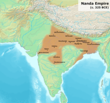
The history of Odisha begins in the Lower Paleolithic era, as Acheulian tools dating to the period have been discovered in various places in the region. The early history of Odisha can be traced back to writings found in ancient texts like the Mahabharata, Maha Govinda Sutta and some Puranas. The region was also known to other kingdoms in region of East Indies due to maritime trade relations.

The Gajapati Empire, was an empire established by the Suryavamsa dynasty or Routray dynasty, who were a medieval Hindu dynasty in the Indian subcontinent. It originated in the region of Trikalinga and reigned from 1434 to 1541 CE. It succeeded the reign of the Eastern Gangas. Under the Emperor Kapilendra Deva, the Gajapati empire stretched from lower Ganga in the north to Kaveri in the south.

<span class="mw-page-title-main">Mukhalingam</span> Village in Andhra Pradesh, India

Mukhalingam, also known as Srimukhalingam or Mukhalinga, is a village panchayat in Jalumuru mandal of Srikakulam district in the Indian state of Andhra Pradesh. Historically known as Kalinganagari, Mukhalingam served as the capital of Eastern Ganga Dynasty from 6th century AD to 12th century AD. Emperor Sri Ananthavarma Chodaganga Devara conquered Utkala in 1122 AD and shifted the capital from Kalinganagari to Caudwara kataka

<span class="mw-page-title-main">North Andhra</span> Geographic region of Andhra Pradesh in India

North Andhra or Uttara Andhra, also known as Kalinga Andhra, is a geographic region in the Indian state of Andhra Pradesh. It is between the Eastern Ghats and the coast of the Bay of Bengal. It comprises six northern districts of the state, Srikakulam, Parvathipuram Manyam, Vizianagaram, Visakhapatnam, Alluri Sitharama Raju and Anakapalli. As of 2011 census of India, the region with six districts has a population of 9,338,177.

Western Odisha is the western part of the state of Odisha in India, extending from the Kalahandi district in the south to the Sundargarh district in the north.

<span class="mw-page-title-main">Eastern Ganga dynasty</span> Medieval era Indian royal Hindu dynasty

The Eastern Ganga dynasty were a large medieval era Indian royal Hindu dynasty that reigned from Kalinga from as early as the 5th century to the mid 20th century. Eastern Gangas ruled much of the modern region of Odisha in three different phases by the passage of time, known as Early Eastern Gangas (493–1077), Imperial Eastern Gangas (1077–1436) and Khemundi Gangas (1436–1947). They are known as "Eastern Gangas" to distinguish them from the Western Gangas who ruled over Karnataka. The territory ruled by the dynasty consisted of the whole of the modern-day Indian state of Odisha, as well as major parts of north Andhra Pradesh, parts of Chhattisgarh and some southern districts of West Bengal. Odia language got official status in their regime following the evolution of the language from Odra Prakrit. The early rulers of the dynasty ruled from Dantapuram; the capital was later moved to Kalinganagara, and ultimately to Kataka and then to Paralakhemundi.

Dandabhukti was an ancient and medieval territory located between the two rivers, Dwarakeswar and Subarnarekha, and situated in the Rarh region of the ancient Bengal. It covered the present-day districts of Bankura, Hooghly, Paschim Medinipur, and Purba Medinipur in West Bengal, India.

<span class="mw-page-title-main">Maritime history of Odisha</span>

The Maritime history of Odisha, known as Kalinga in ancient times, started much before 800 BC according to early sources. The people of this region of eastern India along the coast of the Bay of Bengal sailed up and down the Indian coast, and travelled to Indo China and throughout Maritime Southeast Asia, introducing elements of their culture to the people with whom they traded. The 6th century Manjusrimulakalpa mentions the Bay of Bengal as Kalingodra and in ancient Classical India, the Bay of Bengal was known as Kalinga Sagar, indicating the importance of Kalinga in the maritime trade. The old traditions are still celebrated in the annual Boita Bandana festival including its major celebration at Cuttack on the banks of Mahanadi river called Bali Jatra, and are held for seven days in October-November at various coastal districts, most famous at Cuttack though.

<span class="mw-page-title-main">Kapilendra Deva</span> Founder of the Gajapati Empire

Kapilendra Deva was the founder of the Suryavamsa Gajapati Empire that ruled parts of eastern and southern India with the present-day Odisha as the center of the empire. He ascended to the throne after staging a military coup against the preceding and the last ruler from the Eastern Ganga dynasty, Bhanu Deva IV. He is also referred to as Kapilendra Routray or Sri Sri Kapilendra Deva. Kapilendra claimed descent from the Surya Vamsha of the Mahābhārata and was conferred the regnal title Shri Shri ...(108 times) Gajapati Gaudeshwara NabaKoti Karnata Kalabargeswara i.e. the Lord of Bengal (Gauda), the lord of the Karnataka region or Vijayanagara, the Lord of Kalaburagi and of nine crore subjects.

<span class="mw-page-title-main">Anantavarman Chodaganga</span> First emperor of eastern Ganga dynasty

Gangesvara Anantavarman Chodaganga Deva was an Eastern Ganga monarch who reigned between 1077 CE to 1150 CE. He was the ruler of the Kalinga region from river Ganga to Godavari, and later the early medieval Odisha region with the incorporation of the constituent regions with the decline of the Somavamshis.

<span class="mw-page-title-main">Bhanja dynasty</span> Ancient dynasty originated in fhe Utkala Kingdom

The Bhanja dynasty is a dynasty that originated in the northern and central regions of modern Odisha before the Gupta Empire became an imperial power. The dynasty, of ancient local Kshatriya lineage as documented by Hermann Kulke, succeeded the Vindhyatabi branch of the Nagas of Padmavati, who ruled from the Keonjhar district of Odisha and included Satrubhanja of the Asanpat inscription. The Bhanj later became feudatories of the Bhauma-Kara dynasty.

The Mathara dynasty ruled in the Kalinga region of eastern India during 4th and 5th centuries CE. Their territory included parts of the area between the present-day Ganjam district of Odisha in north and the Srikakulam district in Andhra Pradesh in the south. They appear to have been overthrown by the Pitrbhakta dynasty.

The Pitrbhakta dynasty ruled in the Kalinga region of eastern India in the fifth century CE. Their territory included parts of the present-day northern Andhra Pradesh and the southern Odisha. They probably overthrew the Mathara dynasty.

The Bhauma dynasty, also known as Kara dynasty, ruled in eastern India between 8th and 10th centuries. Their kingdom, called Toshala, included parts of present-day Odisha.

Maharaja Sivakara Deva I or Sivakara Unmattasimha/Unamattakeshari was a powerful monarch of the Bhaumakara dynasty who ruled in the late tertiary part of the 8th century A.D. He was the descendant of Ksemankara Deva who is believed to be the founder of the Bhaumakara rule in ancient Odra and also the earliest organizer of the Varna system in the region. Sivakara Deva I pursued a career of conquest in the eastern part of India establishing the Bhaumakaras as the supreme power in the whole region during his lifetime. According to the Talcher plate of Sivakaradeva III, Sivakaradeva I alias Unmattasimha defeated the king of Radha(south-West Bengal). When Unmattasimha was ruling in Orissa, Bengal was still in a state of disorder, and therefore the Radha king defeated by him can not be identified. However, Sivakara I either started ruling from 756 CE or 786 CE. He subjugated the Eastern Ganga rulers of Kalinga as his vassals. His dominions stretched from the border of Bengal in the north to the river Godavari in the south. He was a devout Buddhist who in 790 built the Sholampura Buddha Vihara and who adopted the epithets of Paramopasaka and Paramatathgata meaning a devout worshiper of Buddha which has been mentioned in the Neulpur charter of the Bhaumakaras. He sent a Buddhist scholar as an emissary to the Chinese emperor Te-tsong or Dezong with valuable Mahayana Buddhist manuscripts and established a new era of maritime trade and cultural relationship between ancient Odisha and China.

<span class="mw-page-title-main">Bhoi dynasty</span> Medieval Odia Hindu dynasty

The Bhoi dynasty or the Yaduvamsa dynasty were a medieval Hindu dynasty from the Indian subcontinent, which originated in the region of Odisha that reigned from 1541 to 1560 CE. Govinda Vidyadhara had usurped the throne from the later weaker Suryavamsa Gajapati Empire rulers as the kingdom started weakening but had a short-lived reign as ruling chiefs of Odisha as the ensuing internal rivalries and constant threats of invasions rendered them weak and were eventually overthrown by Mukunda Deva of Chalukya dynasty in 1560.

Gajapati Rāmachandra Deva I was the founder of the Bhoi dynasty of Khurda in Odisha, India. He became the ruler of Khurda kingdom after defeating Mukunda Deva in 1568. He claimed descent from the Yaduvanshi dynasty which features prominenetly in the Indian epic, Mahabharata. The Odia populace gave him the title of "Thakura Raja" as a mark of respect for renovating the damaged Hindu temples that were destroyed by the invasion of Kalapahad. He was titled as Vira Sri Gajapati Viradhi Viravara Pratapi Ramachandra Deva.

Trikalinga is a region of central-east India, mentioned in several historical sources. Its identification and its relation to the term "Kalinga" is debated among modern historians, who variously identify it as a distinct region to the west of Kalinga, a larger region comprising Kalinga and two other regions, a constituent of the greater Kalinga, or the three divisions of Kalinga proper.

References

Citations

  1. Majumdar, R.C. (1996). Outline of the History of Kalinga. Asian Educational Services. pp. 1, 19. ISBN   9788120611948 . Retrieved 1 May 2021.
  2. 1 2 3 4 5 6 7 8 9 Ganguly, DK (1975). Historical Geography and dynastic History of Orissa (1st ed.). Kolkata: Punthi Pustak. pp. 6–7.
  3. O'Malley, L.S.S. (1 January 2007). Bengal District Gazetteer : Puri. Concept Publishing Company. p. 30. ISBN   978-81-7268-138-8 . Retrieved 2 February 2021.
  4. Padhy, S. C. (2005–2006), "Formation of Orissa Province and Role of Oriyas in Berhampur", Proceedings of the Indian History Congress, 66, Indian History Congress: 1030–1040, JSTOR   44145916 , retrieved 31 December 2020
  5. ODISHA DISTRICT GAZETTEERS GAJAPATI (PDF), GAD, Govt of Odisha, 2002, p. 51
  6. Maclean, C.D. (1877), Standing Information Regarding the Official Administration of the Madras Presidency in each Department, Madras University
  7. R. C. Majumdar 1996, p. 1.
  8. Sudama Misra (1973). Janapada state in ancient India. Bhāratīya Vidyā Prakāśana. p. 78.
  9. Rath, AK (1978). "A note on relation of Parsvanatha and Mahavira with Kalinga". Proceedings of the Indian History Congress, Vol. 39, Volume I (1978): 137. JSTOR   44139344 via JSTOR.
  10. 1 2 Dineschandra Sircar 1971, p. 167.
  11. Dineschandra Sircar 1971, pp. 168–171.
  12. Mano Mohan Ganguly 1912, p. 11.
  13. Ganguly, DK (1975). Historical Geography and Dynastic history of Orissa. Calcutta: Punthi Pustak. pp. 8–9.
  14. Dutt, MN (1895). The Prose English Translation Of The Mahabharata. Calcutta: Elysium Press. p. 291.
  15. Tripathy 1997, p. 4,5,7.
  16. Maltby, Thomas James (1882). Leman, George Downton (ed.). The Ganjam District Manual. Madras: W. H. Moore at Lawrence Asylum Press. p. 2. ISBN   978-1241495909.
  17. Tripathy 1997, p. 6.
  18. Tripathy 1997, p. 13.
  19. Tripathy 1997, p. 53.
  20. Tripathy 1997, pp. 52–54, 58.
  21. Tripathy 1997, pp. 60–64.
  22. Ayyanagar, Krishnaswamy (1919). Sources of Vijaynagar History (PDF). Madras: University of Madras. p. 91,131,132. ISBN   978-8180942808.
  23. Chandramani Nayak 2004, p. 6.
  24. R. C. Majumdar 1996, p. 19.
  25. Tripathy 1997, p. 3.
  26. 1 2 3 4 Raychaudhuri 1953, p. 87-89.
  27. Dineschandra Sircar 1971, p. 168.
  28. 1 2 K. A. Nilakanta Sastri 1988, p. 18.
  29. Gaṅgā Rām Garg (1992). Encyclopaedia of the Hindu World, Volume 1. Concept Publishing Company. ISBN   9788170223740 . Retrieved 28 October 2012.
  30. "Kalingas". www.ancientvoice.wikidot.com. Retrieved 29 November 2018.
  31. Krishna-Dwaipayana Vyasa (March 2008). The Mahabharata of Krishna-Dwaipayana Vyasa, Second Book Sabha Parva. Echo Library. p. 10. ISBN   9781406870442 . Retrieved 28 October 2012.
  32. Raychaudhuri, Hemchandra (2006). Political History Of Ancient India. Genesis Publishing. p. 75. ISBN   9788130702919 . Retrieved 25 October 2012.
  33. https://prepp.in/news/e-492-kalinga-war-ancient-india-history-notes [ bare URL ]
  34. 1 2 Mohamed, Naseema (2005). "First Settlers". Note on the Early History of the Maldives: 9. doi:10.3406/arch.2005.3970 . Retrieved 21 March 2021.
  35. Johannes Bronkhorst 2011, p. 12.
  36. Irfan Habib & Vivekanand Jha 2004, p. 13.
  37. Jagna Kumar Sahu 1997, p. 24.
  38. 1 2 Megasthenes Indica Archived 21 March 2015 at the Wayback Machine
  39. Sailendra Nath Sen (1999). Ancient Indian History and Civilization. New Age International. ISBN   978-81-224-1198-0.
  40. Tripathy 1997, p. 219.
  41. Tripathy 1997, pp. 64–65.
  42. Umakanta Subuddhi 1997, p. 32.
  43. Walter Smith 1994, p. 25.
  44. Walter Smith 1994, p. 26.
  45. Dineschandra Sircar 1971, p. 169.
  46. Manas Kumar Das (24 June 2015), HISTORY OF ODISHA (FROM EARLIEST TIMES TO 1434 A.D.) (PDF), DDCE Utkal University, pp. 109, 111
  47. Sen, Sailendra (2013). A Textbook of Medieval Indian History. Primus Books. pp. 121–122. ISBN   978-9-38060-734-4.
  48. Durga Prasad Patnaik (1989). Palm Leaf Etchings of Orissa. Abhinav Publications. pp. 4–. ISBN   978-81-7017-248-2.
  49. O'Malley, L.S.S. (1 January 2007). Bengal District Gazetteer : Puri. Concept Publishing Company. p. 30. ISBN   978-81-7268-138-8 . Retrieved 2 December 2012.
  50. Sanyal, Sanjeev (10 August 2016). The Ocean of Churn: How the Indian Ocean Shaped Human History. Penguin UK. pp. 82–84. ISBN   978-93-86057-61-7.
  51. Tarling, Nicholas (March 2008). The Cambridge History of Southeast Asia. Cambridge University Press. ISBN   9781139055482.
  52. Hall, DGE (14 May 1981). History of South East Asia. Macmillan Education UK. ISBN   9780333241646.
  53. Briggs, Lawrence Palme (April–June 1950), "The Origin of the Sailendra Dynasty: Present Status of the Question", Journal of the American Oriental Society, 70 (2), American Oriental Society: 83, doi:10.2307/595536, JSTOR   595536
  54. R. C. Majumdar 1933, pp. 121–141.
  55. Patnaik, Durga Prasad (1989). Palm Leaf Etchings of Orissa. Abhinav Publications. ISBN   81-7017-248-9.
  56. Benudhar Patra (November 2005), Kalinga and Burma - A Study in Ancient Relations (PDF), Orissa Review
  57. Eric Casino. "The Barangays of Butuan: Lumad Mindanaoans in China and the Sulu Zone". Asia Mindanaw: Dialogue of Peace and Development (2014): 2.
  58. Aiman Mohamad (1991). Minerva English-Malay Malay-English Dictionary. Kuala Lumpur.{{cite book}}: CS1 maint: location missing publisher (link)
  59. "KBBI – Keling". Kamus Besar bahasa Indonesia.
  60. M. Veera Pandiyan (10 August 2016). "'Keling' and proud of it". The Star online.
  61. KA Nilakanta Sastri (1939). "Foreign Notices Of South India From Megasthenes To Ma Huan". p. 311.

Sources