This article possibly contains original research .(May 2021) |
Nayagarh district | |
|---|---|
  | |
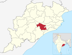 Location in Odisha | |
| Coordinates: 20°06′58″N85°00′36″E / 20.116°N 85.01°E | |
| Country | |
| State | |
| Headquarters | Nayagarh |
| Government | |
| • Collector & District Magistrate | Swadha Dev Singh, IAS |
| • Member of Lok Sabha | Sambit Patra (BJP) |
| Area | |
• Total | 3,890 km2 (1,500 sq mi) |
| Population (2011) [1] | |
• Total | 962,789 |
| • Density | 250/km2 (640/sq mi) |
| Languages | |
| • Official | Odia |
| Time zone | UTC+5:30 (IST) |
| PIN | 752069 |
| Vehicle registration | OD-25 |
| Sex ratio | 0.994 ♂/♀ |
| Lok Sabha constituency | Puri |
| Climate | Aw (Köppen) |
| Precipitation | 1,449.1 millimetres (57.05 in) |
| Website | nayagarh |
| This article is part of a series on |
| Odisha |
|---|
 |
| Governance |
| Topics |
| Districts Divisions |
| GI Products |
Nayagarh district is one of the 30 districts of Odisha state in eastern India. It was created on 01-April-1993 [2] when the erstwhile Puri District was split into three distinct districts, namely Khordha, Nayagarh and Puri.
Contents
The district is bordered by Khordha district to the south and east, Cuttack district to the east and north, Angul district to the north, Boudh district to the northwest, Kandhamal district to the west and Ganjam district to the southwest.
