Debagarh district

Last updated
Debagarh district
Deogarh
Deojharan water fall.jpg
Deojharan waterfall
India Odisha Debagarh district.svg
Location in Odisha
Debagarh district
Debagarh district
Coordinates: 21°31′59″N84°43′59″E / 21.533°N 84.733°E / 21.533; 84.733
CountryFlag of India.svg  India
State Orissa Flag(INDIA).png Odisha
Established1 January 1994
Headquarters Deogarh
Government
   Collector Sri Somesh Kumar Upadhyay IAS
Area
  Total2,781.66 km2 (1,074.00 sq mi)
  Land2,150 km2 (830 sq mi)
Population
 (2011) [1]
  Total312,520
  Rank30
  Density106/km2 (270/sq mi)
Languages
  Official Odia, English
  Local Munda, Kurukh
Time zone UTC+5:30 (IST)
PIN
768108
Vehicle registration OD-28
Sex ratio 976 /
Literacy73.07%
Vidhan Sabha constituency1, Deogarh
Climate Aw (Köppen)
Precipitation 1,014.2 millimetres (39.93 in)
Website www.deogarh.nic.in

Debagarh District also known as Deogarh District is a district of Odisha state, India. Located in the north-western part of the state, it is one of the 30 administrative districts and has its headquarters at Debagarh (Deogarh) town.

Contents

The district covers an area of 2781.66 km². The district has a population of 312,520 (2011 Census). As of 2011 it is the least populous district of Odisha (out of 30). [1]

History

The district was created on 1 January 1994 by bifurcating the erstwhile Sambalpur district. It is domiciled by both tribal and non-tribal people in almost equal proportion.

Deogarh is the former capital of Bamanda or Bamra princely state of British India. The king of this princely state belongs to Ganga vamsi dynasty and one of the extended royal family of Gajapati emperor of Odisha.

Raja Shri Basudeb Sudhal Deb (1869–1903) was an enlightened ruler, he did much to further conditions in princely state and for the cause of Oriya nationalism. His contribution was more towards Literature, Education and Art. He established an educational institution, which is currently well known as Raja Basu Dev High School. His son had equally contributed to the social, cultural and scientific development of Deogarh. Bamanda was the first princely state to introduce postal, telegraph and electricity in India.

Bamanda is a citadel of creative artists which dates back to 5th century A.D. when Mathara Royal Family was at the helm of the Administration. After this dynasty, Ganga Rulers came into power and established their capital at Deogarh. Deogarh attained all-round prosperity during the reign of Raja Basudev Sudhal Dev, the most enlightened rulers of this clan. A new horizon was innovated in the field of communication by the foundation of Jagannath Ballav press in 1886 and publication of a weekly magazine the "Sambalpur Hitaishini" in 1889. It was during his rule that the jail, police station, post offices, Dispensaries were established and irrigation system was introduced. He had a telephone line of 78 Miles connecting Bamara and Barkote in 1900 was the longest in India during that period. Bamanda's own postal system was very developed. It got affiliated to the British Postal system in 1895. Sir Sudhal Dev, the then King of Bamanda had coined and issued postage stamps in his own Kingdom. He had promulgated paper currency also in his state.

After him, his illustrious son Raja Sachidananda Tribhuban Dev undertook the improvement activities of the erstwhile estate. The most outstanding developmental activities was the introduction of the hydro-electric system in Kodarkot water fall by which the Palace, cloth loom, Sugar factory established in 1908 at Rambhei got power supply. During the reign of Bhanuganga Tribhuban Dev, the estate of Bamra was merged with Odisha i.e. on 1 January 1948 and it became a part of the District of Sambalpur.

Geography

Debagarh district
Debagarh district
Debagarh district
Facts and Figures
Date of formation01-Jan-1994
Area2781.66 km2
Forest Land1560.22 km2
Population(2001)2,74,095
Males1,38,913
Females1,35,182
Population density93 per km2
Sex Ratio980 females per 1000 males
Literacy Rate60.78%
No. of Sub-Division1
No. of Tehsil1
No. of Blocks3
No. of Villages7744
Average rainfall1014.2 mm
Postal Code768108
STD Code06641

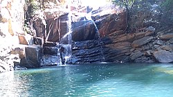
Among various biodiversity rich and ecologically balanced locations,"Pradhanpat" and "Kurudkut" waterfalls are with historical importance and with a salubrious atmosphere around them. Kurudkut is one of the earliest locations where hydroelectricity was generated in Asia.

The district consists mainly of hills. The Hill system of Deogarh has been categorized mainly under four ranges:

  1. The Khajuria Range on the north running from west–east in Badbar-Pragana of Deogarh Police Station having a maximum height of 745 Metres.
  2. The Pradhanpat and Kaidanta Ranges having maximum height of 743 Metres and 816 Metres on the North.
  3. The Pawri Range on the eastern side of the Brahmani River which is 678 Metres in height.
  4. The Ushakothi Range in Kansar & Reamal Police Stations. The hill ranges have elevation ranging from 610 Metres to 762 Metres from the mean Sea Levels.

The soil groups of this district are mainly Sandy, loamy soil and Red soil.

Economy

In 2006 the Ministry of Panchayati Raj named Debagarh one of the country's 250 most backward districts (out of a total of 640). [2] It is one of the 19 districts in Odisha have been receiving funds from the Backward Regions Grant Fund Programme (BRGF). [2]

As it is an industry less district the people depend solely upon agriculture. It is a part of the Red Corridor. [3]

Tourism

The government has undertaken a number of efforts to support tourism in the district, based on its natural environment and cultural heritage.[ citation needed ] There are a number of tourists places listed on the official district website. [4]

Demographics

Historical population
YearPop.±% p.a.
190159,882    
191169,341+1.48%
192172,488+0.44%
193181,007+1.12%
194191,241+1.20%
195198,769+0.80%
1961122,634+2.19%
1971163,243+2.90%
1981197,671+1.93%
1991234,238+1.71%
2001274,108+1.58%
2011312,520+1.32%
source: [5]
Religions in Debagarh district (2011) [6]
ReligionPercent
Hinduism
94.71%
Christianity
4.65%
Other or not stated
0.64%

According to the 2011 census Debagarh district has a population of 312,520, [1] roughly equal to the nation of Iceland. [7] This gives it a ranking of 571st in India (out of a total of 640). [1] The district has a population density of 106 inhabitants per square kilometre (270/sq mi). [1] Its population growth rate over the decade 2001-2011 was 13.88%. [1] Debagarh has a sex ratio of 976 females for every 1000 males, [1] and a literacy rate of 73.07%. 7.16% of the population lives in urban areas. Scheduled Castes and Scheduled Tribes make up 16.67% and 35.33% of the population respectively. [1]

Languages of Debagarh district (2011) [8]

   Odia (89.88%)
   Munda (3.31%)
   Kisan (2.60%)
   Sadri (1.83%)
  Others (2.38%)

At the time of the 2011 Census of India, 89.94% of the population in the district spoke Odia, 3.31% Mundari, 2.6% Kisan, 1.83% Sadri and 0.91% Ho as their first language. [8]

Education

There are a number of educational institutes present including Raja Basudev High School. In 2017 Govt. of Odisha established one Government Polytechnic at Purunagarh in Deogarh district.[ citation needed ] Three engineering branches namely civil, electrical and mining are there .

Transportation

Air: – The nearest airports for visiting places of interest in Deogarh District are at Jharsuguda (98 km), Bhubaneswar (265 km) and Raipur (376 km).

Rail: - The nearest rail heads for Deogarh are at Sambalpur (90 km), Bamra on the Tatanagar-Bilaspur section of Howrah-Nagpur-Mumbai line (103 km), Jharsuguda (98 km) and Rourkela (115 km)

Road: - Deogarh is connected with NH6 (Part of AH46) (Mumbai-Kolkata) and NH200 (Raipur-Chandikhole).The city is 90 km from Sambalpur, 115 km from Rourkela and 265 km from Bhubaneswar.

Politics

Vidhan sabha constituency

Deogarh have only 1 Vidhan sabha constituency. [9] [10]

Related Research Articles

Bargarh is an emerging city and municipality in Bargarh district in the state of odisha in India. It is the administrative headquarters of Bargarh District. Bargarh is popularly known for intensive cultivation of 'paddy', therefore called "Bhata Handi" of Odisha.

<span class="mw-page-title-main">Sambalpur district</span> District of Odisha in India

Sambalpur District is a district in the western part of state of Odisha, India. The historic city of Sambalpur is the district headquarters.

<span class="mw-page-title-main">Gajapati district</span> District of Odisha in India

Gajapati district is a district of Odisha State in India. It was created from Ganjam District on 2 October, 1992. Gajapati district was named after Krushna Chandra Gajapati Narayan Deb, the King of the Paralakhemundi estate and the first Prime Minister of Orissa, who is remembered for his contribution in the formation of a separate state, and inclusion of his estate in Odisha. The district headquarters at Paralakhemundi, formerly a Zamindari, has been clustered within a radius of approximately 5 kilometers around the geometric centre of Paralakhemundi. The District is a part of the Red Corridor. As of 2011 it is the third least populous district of Odisha, after Debagarh and Boudh.

<span class="mw-page-title-main">Angul district</span> District of Odisha in India

Angul district; also known as Anugul, is one of the thirty districts of Odisha in eastern India. The city of Angul is the district headquarters of Angul district. A major industrial hub of the state, the district hosts numerous industries relating to coal, bauxite and steel apart from extensive forests including the Satkosia Tiger Reserve.

<span class="mw-page-title-main">Sundergarh district</span> District of Odisha in India

Sundargarh District is a district in the northwestern part of Odisha state in eastern India.

<span class="mw-page-title-main">Bamra State</span>

Bamra State or Bamanda State, covering an area of 5149 km2, was one of the princely states of India during the period of the British Raj, its capital was in Debagarh (Deogarh). Bamra State acceded to India in 1948.

<span class="mw-page-title-main">Boudh district</span> District of Odisha in India

Boudh District is an administrative and a municipal district, one of the thirty in the Odisha, India. The district headquarters of the Boudh District is the city of Boudh.

Debagarh, also known as Deogarh, is a city in Odisha state of eastern India. Located in the North-Western region of the state, it is the headquarters of Debagarh District that was created on 1 January 1994, after being bifurcated from Sambalpur District.

Sundargarh is a town in Sundergarh district of the Indian state of Odisha. As of 2011 census, the municipality had a population of 45,036. Sundargarh is recognized as an industrial district in Odisha. Steel, fertilizer, cement, ferrovanadium, machine-building, glass, china-clay plants and factories, and spinning mills are some of the major industries of this district. Sundargarh occupies a prominent position in the mineral map of Odisha and is rich in iron ore, limestone, and manganese.

<span class="mw-page-title-main">Kuchinda</span> Town in Odisha, India

Kuchinda is the town and a notified area council in Sambalpur district in the Indian state of Odisha. It is located about 80 km (49.71 mi) from the district headquarters of Sambalpur, and about 48 km (29.83 mi) away from Jharsuguda. Kuchinda is famous for its "Dushera". Kuchinda is also famous for the Gudguda waterfall. Most of the people of Kuchinda sub-division depends on farming. Kuchinda is more of a tribal area.

National Highway 6 & Economic Corridor 1 (EC1), was a National Highway in India that has been separately designated under the new national highway numbering system. It was officially listed as running over 1,949 km (1,211 mi) from Surat to Kolkata. The route was also known as Asian Highway 46 (AH46) & Mumbai - Kolkata Highway and Great Eastern Highway.

<span class="mw-page-title-main">Rairakhol</span> Town in Odisha, India

Redhakhol is a town and a notified area council in Sambalpur district in the Indian state of Odisha.It has the following banks: Canara Bank, DCB Bank, State Bank of India, Union Bank, Utkal Gramin Bank, and Central Bank. Redhakhol town, which is the Sub-Divisional headquarter of Rairakhol Sub-division and surrounded by a green belt of reserve forest, is unique for its natural environment and pollution-free status. The town is 67 K.M. from Sambalpur and 260 K.M. from Bhubaneswar. Sambalpur-Cuttack the old National Highway 42 now renamed as National Highway 55 is passing through this town. After the opening of the Kiakata bridge on Rairakhol-Kiakata State Highway, this town has become a junction point, as it opens easy & straight communication to Phulbani & Berhampur. The historical Deogarh town is situated to its North & is connected by 88 K.M. length of Blacktopping road leading to Ranchi Vijayawada Highway.

Raja Basu Dev High School is an Indian school located in Debagarh, Odisha.

<span class="mw-page-title-main">Garhjat Hills</span>

The Garhjat Hills is a mountain range formed by a series low-lying hills, plateaux, ridges and meadows that stretch into Odisha from the Utkal Plains in the Chotanagpur region of Jharkhand and the Chhattisgarh Plains. The range, also known as the Odisha Highlands, runs in a north east to south west direction for about 382 km along the Odisha coast, covering 76,800 km2 (29,700 sq mi).

<span class="mw-page-title-main">Jharsuguda–Vizianagaram line</span> Railway line in India

The Jharsuguda–Vizianagaram line is a railway line in eastern India. It connects Jharsuguda,516 km (321 mi) from Howrah on the Howrah–Nagpur–Mumbai line, and Titlagarh, which in turn is connected with Vizianagaram, 820 km (510 mi) from Howrah on the Howrah–Chennai main line, and Raipur Junction, 830 km (516 mi) from Howrah on the Howrah–Nagpur–Mumbai line. There are several branch lines, like the 176 km (109 mi) line connecting Rayagada with Koraput on the Kothavalasa–Kirandul line. The line traverses Western Odisha and connects the Howrah–Nagpur–Mumbai line with the Howrah–Chennai main line. It covers small portions of Chhattisgarh and Andhra Pradesh.

Deogarh is a Vidhan Sabha constituency of Debagarh district.

TP Western Odisha Distribution Limited (TPWODL) is a joint venture between Tata Power and the Government of Odisha with the majority stake being held by The Tata Power Company Limited (51%). The Discom TPWODL serves a population of 88 lacs with a customer base of more than 21 lacs. It has a vast distribution area in the Western part of Odisha covering 48,373 sq. km across nine revenue districts of Odisha such as Bargarh, Bolangir, Debagarh, Jharsuguda, Kalahandi, Nuapada, Sambalpur Sonepur and Sundergarh. It procures power from Grid Corporation of Odisha (GRIDCO) at 33KV at various supply points and maintains extensive 33KV, 11KV and LT overhead networks for distribution of electric supply over its entire area of operation. For making reliable power supply, along with prompt service to its consumers, this power distribution company in Odisha has divided its area of power distribution into 5 Circles and 17 Divisions as under: -

Bamra railway station is a railway station on the South Eastern Railway network in the state of Odisha, India. It serves Bamra town. Its code is BMB. It has three platforms. Passenger, Express and Superfast trains halt at Bamra railway station.

Bamra, also referred to as Bamanda was a constituency of the Odisha Legislative Assembly, of the Sambalpur district, Odisha state in India. It was formed in 1951 and was abolished in 1957. It was replaced by the constituencies of Deogarh and Jarsuguda.

References

  1. 1 2 3 4 5 6 7 8 "District Census Handbook 2011 - Jharsuguda" (PDF). Census of India . Registrar General and Census Commissioner of India.
  2. 1 2 Ministry of Panchayati Raj (September 8, 2009). "A Note on the Backward Regions Grant Fund Programme" (PDF). National Institute of Rural Development. Archived from the original (PDF) on April 5, 2012. Retrieved September 27, 2011.
  3. "83 districts under the Security Related Expenditure Scheme". IntelliBriefs. 2009-12-11. Archived from the original on 2011-10-27. Retrieved 2011-09-17.
  4. "Enchanting Tourist Places in Deogarh District" . Retrieved 2011-09-17.
  5. Decadal Variation In Population Since 1901
  6. "Table C-01 Population by Religious Community: Odisha". Census of India, 2011. Registrar General and Census Commissioner of India.
  7. US Directorate of Intelligence. "Country Comparison:Population". Archived from the original on June 13, 2007. Retrieved 2011-10-01. Iceland 311,058 July 2011 est.
  8. 1 2 "Table C-16 Population by Mother Tongue: Odisha". Census of India 2011. Registrar General and Census Commissioner of India.
  9. Assembly Constituencies and their Extent
  10. Seats of Odisha