
The South Eastern Railway is one of the 19 railway zones in India. It is headquartered at Garden Reach, Kolkata, West Bengal, India. It comprises Adra railway division, Chakradharpur railway division, Kharagpur railway division and Ranchi railway division.

Debagarh District also known as Deogarh District is a district of Odisha state, India. Located in the north-western part of the state, it is one of the 30 administrative districts and has its headquarters at Debagarh (Deogarh) town.

Nagpur district is a district in the Vidarbha region of Maharashtra state in central India. The city of Nagpur is the district administrative centre. The district is part of Nagpur Division.
Debagarh, also known as Deogarh, is a city in Odisha state of eastern India. Located in the North-Western region of the state, it is the headquarters of Debagarh District that was created on 1 January 1994, after being bifurcated from Sambalpur District.
Nandura (नांदुरा) is a city in Buldhana district in Maharashtra state. Nandura is the headquarters of Nandura taluka. Nandura is situated on the National Highway No. 6 and the Mumbai-Howrah railway line. The municipality of Nandura was established during the British Raj in 1931. The place is major supplier of milk products to all nearby area.
Parola is a city and a municipal council in Jalgaon district in the Indian state of Maharashtra. It is located on the Hajira (Surat)–Dhule–Kolkata national highway 6. The municipal council was established by the British government before the independence of India. This City is centuries old known for the two main features such as the Shree Balaji Temple and The Parola fort Also known as the native of Rani Laxmibai of Jhansi. City and Fort Build by Jahagirdar Sadashiv Rao Damodar Newalkar the great grandfather in law of Rani Lakshmibai Jhansi.

Mahasamund district is a district in Chhattisgarh state in central India. The city of Mahasamund is the district headquarters. The district is particularly famous for the historical temple town of Sirpur besides the Mahanadi river.
National Highway 6 & Economic Corridor 1 (EC1), was a National Highway in India that has been separately designated under the new national highway numbering system. It was officially listed as running over 1,949 km (1,211 mi) from Surat to Kolkata. The route was also known as Asian Highway 46 (AH46) & Mumbai - Kolkata Highway and Great Eastern Highway.
Podar Education Network is a network of schools in India, managed by the Anandilal Podar Trust of Mumbai. The trust was established in 1927 by a Mumbai-based businessman Sheth Anandilal Podar. As of December 2014, the group had 116 schools across India. It was awarded the status of International Baccalaureate World School in 2005, and in 2011 was CIS certified.
The city of Nagpur is strategically located in central India. It has a vast railway network and its road network is well-maintained to avoid congestion. There are 4 modes of transportation in Nagpur. Nagpur is connected to India's four major metropolitan areas by road, rail and air. Auto rickshaws operate in most parts of the city, and are the main form of hired transport.

Bhusawal railway division is one of the five railway divisions of the Central Railway (India) zone of Indian Railways, located at Bhusawal in the Jalgaon district of Maharashtra state in western India. The other railway divisions are: Mumbai CSMT, Nagpur, Solapur and Pune. There are 115 railway stations in the Bhusawal railway division.

This article gives a list of the territories of the dioceses of the Catholic Church in India.

Durg Junction Railway Station, is a junction station located in the Indian state of Chhattisgarh. It serves Durg, Bhilai city and the adjoining areas of it. Durg Junction is the part of South East Central Railway. It is one of the largest railway junctions of Chhattisgarh in terms of network. It is also one of the most prominent and important station in Howrah–Nagpur–Mumbai line. It is an 'A' grade station of Indian Railways in terms of passenger services.
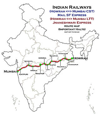
The 12809 / 12810 Howrah–Mumbai CSMT Mail is a Superfast Express train belonging to Indian Railways - South Eastern Railways that runs between Howrah Junction and Mumbai CSMT in India.

National Highway 53, combination of old, & is a national highway in India. It connects Hajira in Gujarat and Paradeep port in Odisha. NH-53 traverses the states of Gujarat, Maharashtra, Chhattisgarh and Odisha in India. The road is the part of AH46 network in India and it is officially listed as running over 1975 km (1227 mi) from Kolkata to Surat. it is also known as Surat - Kolkata Highway. It passes through Maharashtra, Chhattisgarh and Odisha states.
National Highway 49 is a primary National Highway in India. This highway runs from Bilaspur in the Indian state of Chhattisgarh to Kharagpur in West Bengal. Starting from NH 130 near Bilaspur, it terminates at NH 16 near Kharagpur, West Bengal. The highway is part of AH46 network in India. This national highway is 668 km (415 mi) long.

National Highway 161,, is a National Highway in India running through the states of Maharashtra and Telangana of India. The National Highway 161 joins the cities of Akola, Washim, Hingoli, Nanded, Degloor, Bichkunda, Pitlam, Nizampet, Shankarampet(A), Jogipet, Sanga Reddy.
The Bharatmala Pariyojna is an ongoing project that will interconnect 550 District Headquarters through a minimum 4-lane highway by raising the number of corridors to 50 and move 80% freight traffic to National Highways by interconnecting 24 logistics parks, 66 inter-corridors (IC) of total 8,000 km (5,000 mi), 116 feeder routes (FR) of total 7,500 km (4,700 mi) and 7 north east Multi-Modal waterway ports. The project also includes development of tunnels, bridges, elevated corridors, flyovers, overpass, interchanges, bypasses, ring roads etc. to provide shortest, jam free & optimized connectivity to multiple places, it is a centrally-sponsored and funded Road and Highways project of the Government of India. This ambitious umbrella programme will subsume all existing Highway Projects including the flagship National Highways Development Project (NHDP), launched by the Atal Bihari Vajpayee government in 1998. Bharatmala is mainly focused on connecting remote areas and satellite cities of megacities such as Bengaluru, Pune, Hyderabad etc. The total investment for 83,677 km (51,994 mi) committed new highways is estimated at ₹10.63 lakh crore (US$130 billion), making it the single largest outlay for a government road construction scheme. The project will build highways from Maharashtra, Gujarat, Rajasthan, Punjab, Haryana and then cover the entire string of Himalayan territories - Jammu and Kashmir, Himachal Pradesh, Uttarakhand - and then portions of borders of Uttar Pradesh and Bihar alongside Terai, and move to West Bengal, Sikkim, Assam, Arunachal Pradesh, and right up to the Indo-Myanmar border in Manipur and Mizoram. Special emphasis will be given on providing connectivity to far-flung border and rural areas including the tribal and backward areas.
National Highway 161A, commonly as NH 161A, is a National Highway running through states of Karnataka and Maharashtra, with a total length 507 Kilometres that connects Akot, Maharashtra to Bidar, Karnataka. National Highway 161A joins the cities of Akot, Akola, Barshitakli, Mangrulpir, Manora, Digras, Arni, Mahur, Kinwat, Himayatnagar, Mudkhed, Waghala, Mukhed, Maharashtra–Karnataka border in central southern India with each other. It is an auxiliary route of National Highway 61.
