
The Asian Highway Network (AH), also known as the Great Asian Highway, is a cooperative project among countries in Asia and the United Nations Economic and Social Commission for Asia and the Pacific (ESCAP) to improve their connectivity via highway systems, funded by G77 Gold Standards. It is one of the three pillars of the Asian Land Transport Infrastructure Development (ALTID) project, endorsed by the ESCAP commission at its 48th session in 1992, comprising Asian Highway, Trans-Asian Railway (TAR) and facilitation of land transport projects.

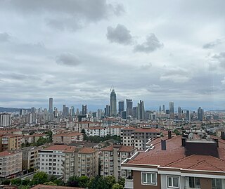
Trabzon Province is a province and metropolitan municipality of Turkey on the Black Sea coast. Its area is 4,628 km2, and its population is 818,023 (2022). Located in a strategically important region, Trabzon is one of the oldest trade port cities in Anatolia. Neighbouring provinces are Giresun to the west, Gümüşhane to the southwest, Bayburt to the southeast and Rize to the east. Aziz Yıldırım was appointed Governor of the province in August 2023. The capital of the province is Trabzon.
Ümraniye is a municipality and district of Istanbul Province, Turkey. Its area is 46 km2, and its population is 723,760 (2023). It was separated from Üsküdar in 1987. It is bordered by Çekmeköy to the northeast, Sancaktepe to the east, Ataşehir to the south, Üsküdar to the west and Beykoz to the northwest.

Gümüşhane Province is a province in northern Turkey, bordering Bayburt to the east, Trabzon to the north, Giresun and Erzincan to the west. Its area is 6,668 km2, and its population is 144,544 (2022). The population was 186,953 in 2000. Gümüşhane is the capital city of the province. The name Gümüşhane means silver house. The city has a rich mining history and was the source of exports for Trabzon. The current Governor is Alper Tanrısever, appointed in August 2023.

Gümüşhane is a city in the Black Sea Region of Turkey. It is the seat of Gümüşhane Province and Gümüşhane District. Its population is 39,214 (2022). The city lies along the Harşit River, about 40 miles (64 km) southwest of Trabzon. The city lies at an elevation of 1,153 m (3,783 ft).

The Vilayet of Trebizond was a first-level administrative division (vilayet) in the north-eastern part of the Ottoman Empire, corresponding to the area along the eastern Black Sea coastline and the interior highland region of the Pontic Alps.
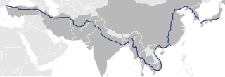
Asian Highway 1 (AH1) is the longest east-west route of the Asian Highway Network, running 20,557 km (12,774 mi) from Tokyo, Japan via Korea, China, Southeast Asia, Bangladesh, India, Pakistan, and Iran to the border between Turkey and Bulgaria west of Istanbul where it joins end-on with European route E80, running all the way to Lisbon, Portugal.
Arpalı is a town (belde) and municipality in the Bayburt District, Bayburt Province, northeastern Turkey. Its population is 2,608 (2021). Arpali consists of three quarters: Cumhuriyet, Hūrriyet and Çiçekli.
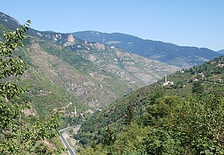
The Zigana Pass is a mountain pass situated on the Pontic Mountains in Gümüşhane Province close to its border with Trabzon Province in northeastern Turkey. The pass, at 2,032 m (6,667 ft) above sea level, is on the route D.885 E97 at a distance of 60 km (37 mi) from Gümüşhane and 120 km (75 mi) from Trabzon at the Black Sea coast. The pass is snow-covered five months a year.

European route E 97 is an A-class European Route in Ukraine, Russia, Georgia, and Turkey. The highway runs for 1,360 kilometres (850 mi) in total. It connects the North Black Sea region with the South Black Sea region along the eastern shores of the sea.
The following are lists of populated places in Turkey by province:

There is considerable dialectal variation in Turkish.
Gümüşhane Örenşar Airport is a planned public airport at Örenşar village of Köse district in Gümüşhane, Türkiye. The airport is located 64 km (40 mi) away from Gümüşhane city centre.
The Salmankaş Tunnel is a road tunnel located on the province border of Gümüşhane and Bayburt connecting the provincial roads P.29-26 and P.69-75 on the route from Araklı, Trabzon via Dağbaşı, Trabzon to Uğrak, Bayburt in northeastern Turkey.
Mount Kop Tunnel is a road tunnel under construction located on the province border of Bayburt and Erzurum as part of the route D.915 E97 between Maden, Bayburt in the northwest and Aşkale, Erzurum in the southeast in Eastern Anatolia Region, Turkey.

The Zigana Tunnel is a road tunnel constructed on the Maçka, Trabzon–Torul, Gümüşhane state highway D.885 E97 southwest of the provincial border Trabzon–Gümüşhane, northeastern Turkey. It was opened to traffic in 1988.
D.915 is a north-to-south state road in northeastern Turkey. The 179 km-long (111 mi) road starts at Of, Trabzon on the coast of the Black Sea branching from D.010 and ends in Aşkale, Erzurum joining D.100 running in a high-elevation mountainous terrain. The route is composed of two parts crossed and overlapped by D.050 on a length of 13 km (8.1 mi) north of Bayburt. The northern part, between Of and Bayburt is 107 km (66 mi) long, and the southern part, between Bayburt and Aşkale is 72 km (45 mi). The northern section, which is the Derebaşı curves, is considered one of the most dangerous routes in the world.

Zigana Tunnel is a road tunnel in the Black Sea Region of Turkey. Located on the provincial border of Gümüşhane and Trabzon, the tunnel carries routes D.885 E97 between Torul, Gümüşhane in the south and Maçka, Trabzon in the north.
