Sambalpur district

Last updated

Sambalpur district
Ghanteswari Temple 02.jpg
Huma, Sambalpur.jpg
Top: Ghanteswari Temple
Bottom: Mahanadi near Huma
India Odisha Sambalpur district.svg
Location in Odisha
Sambalpur district
Sambalpur district
Coordinates: 21°27′58″N83°58′59″E / 21.466°N 83.983°E / 21.466; 83.983
CountryFlag of India.svg  India
State Orissa Flag(INDIA).png Odisha
Headquarters Sambalpur
Government
   Collector & District Magistrate Ms Ananya Das, IAS [1]
  Divisional Forest Officer Cum Wildlife WardenSanjeet Kumar, IFS
   Superintendent of Police Kanwar Vishal Singh, IPS
Area
  Total6,702 km2 (2,588 sq mi)
Population
 (2011)
  Total1,041,099
  Density122/km2 (320/sq mi)
Languages
  Official Odia, English
  Local Sambalpuri, Kurukh, Munda, Kharia
Time zone UTC+5:30 (IST)
PIN
768 xxx
Telephone code663
Vehicle registration OD-15, OR-15(till 2012)
Sex ratio 1.031 /
Literacy67.25%
Lok Sabha constituency Sambalpur
Vidhan Sabha constituency4
Website www.sambalpur.nic.in

Sambalpur District is a district in the western part of state of Odisha, India. The historic city of Sambalpur is the district headquarters.

Contents

The district is located in the Mahanadi River basin. It has a total area of 6,702 km2 (2,588 sq mi), of which almost 60% of the district is covered in dense forest. The district is bounded by Deogarh District to the east, Bargarh and Jharsuguda districts to the west, Sundergarh District to the north, and Subarnapur and Angul districts in the south.

Sambalpur City is the connecting city between Chhattisgarh and Odisha. Whereas it used to be known for its importance as a diamond trading centre, nowadays it is mainly known for its textiles, especially the Sambalpuri Saree.

History

In Lasa near Kuchinda, a stone celt was found dating back to the Paleolithic period. Proto-historic writing was found in a cave in nearby Jharsuguda district.

The region was most likely in the pre-Maghadan empire of Mahapadmananda. However there is no mention of the territory in Mauryan inscriptions, so it is unknown whether the Mauryans controlled this region or not. After the collapse of the Mauryan empire, This region ruled by the Chedis.It was most likely part of Kharavela's empire. Sambalpur is mentioned in the book of Ptolemy (2nd century) as Sambalaka on the river Manada (the Mahanadi River), and by the Romans for their export of numerous diamonds, which were mined in the Mahanadi until the early 17th century. After Kharevala, the Megha dynasty ruled the region.Then become part of Dakhina Koshala In the 4th century CE, the Allahabad inscription records Samudra Gupta defeated Mahendra of Kosala, corresponding roughly to present day Chhattisgarh plains and western Odisha. Although not annexed to the Gupta empire, Kosala remained within Gupta spheres of influence evidenced by presence of Gupta coins in the region. [2]

Padmasambhava, one of the main early scholars of Tibetan Buddhism, was said to be the son of the king of Sambhal of Oddiyana. Almost most historians see this area as the Swat Valley, some cite literary and archaeological evidence to associate Oddiyana with modern-day Odisha. There is evidence to suggest Sambalpur was a centre of Tantric philosophy. [2]

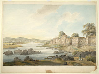
In the 6th century, the Sarabhpuriyas from Sarabha (now identified as Sirpur in Chhattisgarh) came to prominence. Their territory included present-day Sambalpur district, as well as parts of Kalahandi. They were succeeded by the Panduvamshis, whose king, Tivaradeva, tried to expand east of Kosala into Utkala, now coastal Odisha. Although he failed, he kept control of Kosala. In the last decades of the 9th century, the Somavamshis ruled over present-day Kosala. Janamejaya I expanded his domain south and east, and defeated the Kalachuris. His son Yayati was blocked by the Kalachuris when attempting to expand into the north and west of Kosala. The Somavamshis were defeated during Rajendra Chola's northern expedition. In the chaos that followed, Yayati II stabilized the kingdom, which corresponded to modern Odisha. His son beat off Kalachuri invasions during his reign, but the kingdom soon collapsed. Kosala fell into Telugu Choda hands, who had aided a rival king who defeated the Somvamshis. The Telugu Chodas were soon driven out by the Kalachuris. The Kalachuris soon began a long struggle with the Eastern Ganga dynasty, which ended 100 years after when the Gangas drove the Kalachuris out around 1211.After Eastern Ganga dynasty , this area ruled by mighty Gajapati Empire.Under Kapilendra Deva, Gajapatis became an empire stretching from the lower Ganga in the north to the Kaveri in the south.But,continued aggression of the Bengal sultanate from the north and Vijayanagara and Bahmani empires from the south weakened Gajapati empire ,Ultimately Balarama Deva, a Chauhan Rajput from North India founded Chauhan rule in western Orissa.The Chauhans continued ruling independently until the mid 18th century. The rulers then were weak, and real power rested in the diwans. Akbar Ray was the most powerful of these diwans. Ray soon took Sambalpur by force, and antagonised the Marathas of Nagpur. However he was soon overthrown by Jayant Singh in 1781. However, the state faced constant attack by the Marathas of Nagpur, who attempted to subdue the kingdom by force. Eventually, in 1800, they conquered the kingdom and placed a governor there and imprisoned the Chauhans in Chandrapur. During the Second Anglo-Maratha War in 1804, Sambalpur fell into British hands. However these territories were returned to the Marathas in 1806. After the Third Anglo-Maratha war in 1817, Sambalpur became officially British territory and the Chauhans were restored to the throne. However they lacked the former authority over their feudal lords which they had before. [2]

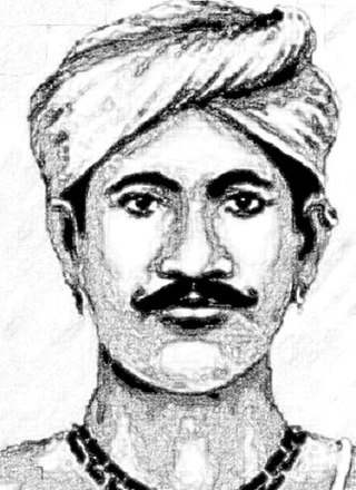
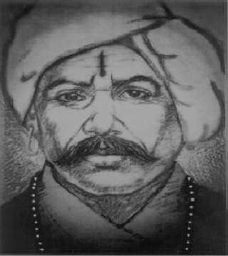
In 1827, the king Maharaja Sai died and his widow was placed on the throne. Incensed by the breach of custom of letting a woman rule, many of the Gond and Binjhal landlords, threatened by caste Hindu favourites of the rani, supported a rival claimant Surendra Sai. The insurgency lasted for a long time until British troops defeated the insurgents. The British then deposed the rani and placed a distant descendant on the throne. [2]

When Sambalpur's ruler died without a direct male heir in 1849, the British seized the state under the doctrine of lapse. During the 1857 rebellion, mutineers stationed in Sambalpur broke Surendra Sai and his companions out of jail, and they soon raised an army against the British. While initially he simply wanted his and his brother's sentences commuted, when the British proposed harsher punishments and began closely guarding him, he escaped to where his brother had gathered 2000 men. Many of the principal zamindars were mustering their paiks against the British. However, the British came down with troops from Nagpur, the Madras Presidency and Chota Nagpur. They defeated the insurgents in open country and by February 1858 had taken back most of the district, but the insurgents were able to use the dense jungles and difficult terrain to their advantage. By 1861, the British adopted a more conciliatory approach to surrendering rebels, and finally in 1862 Surendra Sai surrendered. However the insurgency still continued and in 1864, Surendra Sai was arrested and his brothers too. They were all put in prison, where they died. Today Surendra Sai and his rebels are honoured as freedom fighters. [2]

It was attached to the British Bengal Presidency, but was transferred to the Central Provinces in 1862. The district was transferred back to Bengal in 1905, but the subdivisions of Phuljhar and Chandarpur-Padampur remained with the Central Provinces. Bengal's Odisha division became part of the new province of Bihar and Orissa in 1912, and in 1936 became the separate province of Odisha. In 1890, the British replaced Odia with Hindi as the language of administration. Beginning in Sambalpur and spreading throughout the state, the Odia language agitation forced the British to back down. [2]

Sambalpur had its own contributions to the freedom struggle such as Chandra Shankar Behera, Nilakantha Das, Kastaram Tanti, who propagated ideals of freedom struggle among the people. [2]

After Indian Independence in 1947, Odisha became an Indian state. Earlier Sambalpur District included also the districts of Bargarh, Jharsuguda and Debagarh. which was subsequently divided into four separate districts. Bargarh was separated in 1993, and Jharsuguda and Debagarh districts were separated in 1994.

It is currently a part of the Red Corridor. [3]
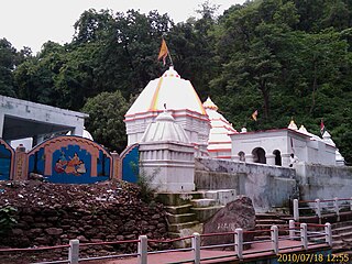
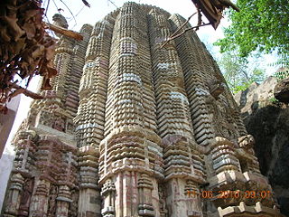
Asta Sambhus

In the district of Sambalpur a large numbers of Shiva temples were built during the Chauhan period.

Economy

The economy of Sambalpur District is basically dependent on agriculture and secondly on forests. Forests play an important role in the economy in terms of contribution to revenue, Domestic Product as well as dependence of people for livelihood. The people living adjacent to the reserved forests of Sambalpur Forest Division are heavily dependent on these forests. In the past Sambalpur has been a great centre of diamond trade. Kendu leaf (Diospyros Melanoxylon) is also produced in Sambalpur. Kendu leaf is one of the most important non-wood forest products of Sambalpur and is also called as green gold of Odisha. Lately industrialisation has started in the district and the prime industries of power, alumina and steel have been established. The place is famous for its globally renowned textile bounded patterns and fabrics locally known as Baandha. Sambalpur is famous for its Hand loom textile works. Popularly known as Sambalpuri Textile. It has earned international fame for its unique pattern, design and texture. Apart from textiles, Samabalpur has a rich tribal heritage and fabulous forestlands.

In 2006 the Ministry of Panchayati Raj named Sambalpur one of the country's 250 most backward districts (out of a total of 640). [4] It is one of the 19 districts in Odisha currently receiving funds from the Backward Regions Grant Fund Programme (BRGF). [4]

Demographics

Historical population
YearPop.±%
1901215,645    
1911249,710+15.8%
1921261,043+4.5%
1931291,723+11.8%
1941328,576+12.6%
1951355,685+8.3%
1961445,745+25.3%
1971549,157+23.2%
1981682,700+24.3%
1991809,017+18.5%
2001930,476+15.0%
20111,041,099+11.9%
Source: Census of India [5]
Religions in Sambalpur district (2011) [6]
ReligionPercent
Hinduism
92.61%
Christianity
4.86%
Islam
1.93%
Other or not stated
0.60%

According to the 2011 census Sambalpur district has a population of 1,041,099, [7] roughly equal to the nation of Cyprus [8] or the US state of Rhode Island. [9] This gives it a ranking of 433rd in India (out of a total of 640). The district has a population density of 158 inhabitants per square kilometre (410/sq mi). Its population growth rate over the decade 2001–2011 was 11.63%. Sambalpur has a sex ratio of 973 females for every 1000 males, and a literacy rate of 76.91%. 29.59% of the population lives in urban areas. Scheduled Castes and Scheduled Tribes make up 18.43% and 34.12% of the population respectively. [7]

Languages

Languages of Sambalpur district (2011) [10]

   Odia (52.41%)
   Sambalpuri (26.38%)
   Kisan (4.98%)
   Hindi (3.98%)
   Mundari (3.88%)
   Sadri (1.85%)
   Kharia (1.49%)
  Others (5.03%)

At the time of the 2011 Census of India, 52.41% speak Odia, 26.38% Sambalpuri, 4.98% Kisan, 3.98% Hindi, 3.88% Mundari, 1.85% Sadri and 1.49% Kharia as their mother tongue. [10]

Culture

Tourism

Samaleswari, the presiding deity of this region is enshrined at Samlei Gudi on the bank of Mahanadi River. [11] The other temple of importance is the Budharaja Temple, dedicated to Shiva and is perched atop the Budharaja hill. These temples are located at a few kilometres' distance from Sambalpur. The Hirakud Dam, the longest earthen dam of the world, is some 15 kilometres from Sambalpur.

Notable people

Politics

Vidhan sabha constituencies

The following is the 4 Vidhan sabha constituencies [13] [14] of Sambalpur district and the elected members [15] of that area

No.ConstituencyReservationExtent of the Assembly Constituency (Blocks)MemberParty
15 Kuchinda STKuchinda (NAC), Kuchinda, Bamra, JamankiraKishore Chandra Naik BJD
16 Rengali SCRengali, Dhankauda, Maneswar (part)Nauri Nayak BJP
17 Sambalpur NoneSambalpur (M), Burla (NAC), Hirakud (NAC) Jaynarayan Mishra BJP
18 Rairakhol NoneRairakhol (NAC), Rairakhol, Jujomura, Naktideul, Maneswar (part)Er. Rohit Pujari BJD

Related Research Articles

<span class="mw-page-title-main">Odisha</span> State in Eastern India

Odisha, formerly Orissa, is an Indian state located in Eastern India. It is the eighth-largest state by area, and the eleventh-largest by population, with over 41 million inhabitants. The state also has the third-largest population of Scheduled Tribes in India. It neighbours the states of Jharkhand and West Bengal to the north, Chhattisgarh to the west, and Andhra Pradesh and Telangana to the south. Odisha has a coastline of 485 kilometres (301 mi) along the Bay of Bengal in Indian Ocean. The region is also known as Utkaḷa and is mentioned by this name in India's national anthem, Jana Gana Mana. The language of Odisha is Odia, which is one of the Classical Languages of India.

Bargarh is an emerging city and municipality in Bargarh district in the state of odisha in India. It is the administrative headquarters of Bargarh District. Bargarh is popularly known for intensive cultivation of 'paddy', therefore called "Bhata Handi" of Odisha.

<span class="mw-page-title-main">Burla, India</span> Locality in Odisha, India

Burla is a locality in Sambalpur city in the state of Odisha, India. It earlier had a Notified Area Council (NAC) until 2014 after which it was included in Sambalpur city under Sambalpur Municipal Corporation (SMC). It was earlier a small town on the banks of Mahanadi. One can reach this place by road with National Highway 6 which is one of the busiest trunk routes in India as it connects Hazira to Kolkata. Hirakud Railway Station is at one end of the town and a walking distance from the Mahanadi Coal Limited (MCL).

<span class="mw-page-title-main">Balangir district</span> District of Odisha in India

Balangir District, also called Bolangir District, is a district situated in Odisha state of India. The district has an area of 6,575 km2 (2,539 sq mi), and a population of 1,648,997. The town of Balangir is the district headquarters. The composition of the land is predominantly rural. Other important big & small towns in Balangir district are Titlagarh, Patnagarh, Kantabanji, Loisingha, Saintala, Belpada, Tushra, Agalpur, Deogaon, Chudapali, Biripali, Bhalumunda, Bangomunda, Sindhekela, Turekela and Muribahal.

<span class="mw-page-title-main">Nuapada district</span> District of Odisha in India

Nuapada district is an area of Odisha state in India. Nuapada town is the headquarters of the district. It has one subdivision: Nuapada, and five blocks: Khariar, Sinapali, Boden, Komna, and Nuapada. Nuapada District has three Notified Area Councils: Khariar, Khariar Road, and Nuapada, six tehsils and more villages such as Gandabahali, Tukla, Hatibandha, Duajher, Bargaon, Tarbod, Udyanbandh, and Larka.

<span class="mw-page-title-main">Jharsuguda district</span> District in Odisha, India

Jharsuguda is a district in Odisha, India with Jharsuguda town as its headquarters. This region is rich in coal and other mineral reserves. Of late, many small and medium scale iron and steel units have been set up in the vicinity of Jharsuguda town, giving impetus to the industrial growth of the district.

<span class="mw-page-title-main">Bargarh district</span> District of Odisha in India

Bargarh District is an administrative district of Odisha state in eastern India. The city of Bargarh is its district headquarters. The district was carved out of the erstwhile district of Sambalpur on 1 April 1993.

<span class="mw-page-title-main">Boudh district</span> District of Odisha in India

Boudh District is an administrative and a municipal district, one of the thirty in the Odisha, India. The district headquarters of the Boudh District is the city of Boudh.

Jharsuguda is a city and district headquarters of Jharsuguda district of Odisha, India. It is an industrial hub, consisting mainly of metallurgical industries. It is well connected to major cities of India through the rail network, and a recently inaugurated Jharsuguda Airport, now renamed as Veer Surendra Sai Airport. It is popularly known as the "Powerhouse of Odisha" due to its Mega Steel, Aluminium & Power Projects. Its First Industrialist in SSI Steel Sector of the Region was Mr Jayprakash Badhan. Jharsuguda has often been referred as "Little India" as well because of its diverse demography, language and culture. One of the oldest bar and hotel in region is Kalinga Bar

Sambalpur is the fifth largest city in the Indian State of Odisha. It is located on the banks of river Mahanadi, with a population of 335,761. Prehistoric settlements have been recorded there. It is the home of the Sambalpuri sari.

Western Odisha is the western part of the state of Odisha in India, extending from the Kalahandi district in the south to the Sundargarh district in the north.

<span class="mw-page-title-main">Sambalpuri language</span> Indo-Aryan language spoken in western Odisha, India

Sambalpuri is an Indo-Aryan language variety spoken in western Odisha, India. It is alternatively known as Western Odia, and as Kosali, a recently popularised but controversial term, which draws on an association with the historical region of Dakshina Kosala, whose territories also included the present-day Sambalpur region.

Lakhanpur is a tehsil in Jharsuguda district, Odisha, India. It is one among the largest block of Odisha and a village under Brajrajnagar assembly constituency and Bargarh parliamentary constituency.

<span class="mw-page-title-main">Veer Surendra Sai Airport</span> Airport in Odisha, India

Veer Surendra Sai Airport, also known as Jharsuguda Airport, is a domestic airport serving Jharsuguda, Odisha, India. The airport is located 5 kilometres (3.1 mi) north-east from the city centre. The airport is located in Durlaga, approximately 8.5 km (5.3 mi) from Jharsuguda Junction Railway Station and around 63 kilometres from Sambalpur city. The airport is named after the revolutionary Veer Surendra Sai and it is the second commercial airport in the state of Odisha. The airport caters to areas like districts of Jharsuguda, Sambalpur, Sundergarh, Bargarh and Debagarh.

<span class="mw-page-title-main">History of Sambalpur</span> Historic site in Odisha, India

Sambalpur is a district of Odisha. Sambalpur city is the headquarter of Sambalpur district. Sambalpur is the cultural capital of Western Odisha.

<span class="mw-page-title-main">Sambalpur State</span>

Sambalpur State, also known as Hirakhand Kingdom was a kingdom founded in 1570. It ruled over Western Odisha and Eastern Chhattisgarh in central-eastern India prior to the Maratha occupation in 1800 AD. From 1849 AD it was integrated with British Raj as a British District. Its capital was present-day Sambalpur city in Western Odisha.

Ambabhona is a rural village in Bargarh district, Odisha. The 2011 India census shows Ambabhona to have a population of 1,746. A police station is located in the village. The Kedarnath Temple stands besides the Mahanadi river at Sambalpur, just south of the village. It was completed by 1765 during the Sambalpur State reign of Ajit Singh.

Balarama Deva or Balaram Deo was the first Chauhan ruler of Sambalpur State and the tenth in line ruler of the Chauhan dynasty in the Western Odisha region during the sixteenth century. He was a powerful ruler and an excellent military strategist who ruled the hilly and forest tracts of western Odisha that was mostly inhabited by different tribal or aboriginal communities. After his ascension to the throne in the year 1570 CE, he secured the region from the neighboring Ratanpur's Haihayas and build a strong state surpassing the glory of his ancestral Chauhan state of Patna (Bolangir). Balarama Deva had also provided military assistance to the Gajapati king Ramachandra Deva of Khurda Kingdom and help to defend Khurda kingdom from the invading Muslim armies who either belonged to the Mughal Dynasty or the Golconda Sultanate. After consolidation of his authority over the regions of western Odisha and now parts of the state of Chattishgarh, Balarama Deva himself installed the idol of Goddess Samleswari as the head family deity which began the era of cultural rejuvenation in the region.

<span class="mw-page-title-main">Madho Singh (Ghess)</span> Indian rebel

Madhab Singh Bariha or Madho Singh was the Binjhal Zamindar (landlord) of Ghess locality of Bargarh district in Odisha and was a close associate of Veer Surendra Sai in the Sambalpur uprising against the British East India Company. He was hanged to death at the age of 72 on 31 December 1858 at Jail Chowk of Sambalpur, after being caught in the same year for his ferocious and heroic resistance to the British takeover of the region with their appalling policies. Three out of his four valiant sons were martyred while the eldest was sentenced to life imprisonment. His granddaughter Purnima committed suicide after the British hanged her rebellious husband from the Sonakhan Zamindari at Raipur.

<span class="mw-page-title-main">Karunakar Singh</span> Gond chieftain and anti-British rebel (d. 1858)

Karunkar Singh Naik, commonly known as Karunakar Singh, was an Indian chieftain and rebel leader. He was the Gond Zamindar of Kolabira in what is today the Jharsuguda district of Odisha.

References

  1. "Odisha Govt effects major IAS reshuffle: Ananya das appointed Sambalpur Collector". Argus News. 16 June 2022. Retrieved 14 September 2022.
  2. 1 2 3 4 5 6 7 "Orissa district gazetteers : Sambalpur". INDIAN CULTURE. Retrieved 13 May 2021.
  3. "83 districts under the Security Related Expenditure Scheme". IntelliBriefs. 11 December 2009. Retrieved 17 September 2011.
  4. 1 2 Ministry of Panchayati Raj (8 September 2009). "A Note on the Backward Regions Grant Fund Programme" (PDF). National Institute of Rural Development. Archived from the original (PDF) on 5 April 2012. Retrieved 27 September 2011.
  5. "Decadal Variation In Population Since 1901". www.censusindia.gov.in.
  6. "Table C-01 Population by Religious Community: Odisha". Census of India, 2011. Registrar General and Census Commissioner of India.
  7. 1 2 "District Census Handbook 2011 - Sambalpur" (PDF). Census of India . Registrar General and Census Commissioner of India.
  8. US Directorate of Intelligence. "Country Comparison:Population". Archived from the original on 13 June 2007. Retrieved 1 October 2011. Cyprus 1,120,489 July 2011 est.
  9. "2010 Resident Population Data". U. S. Census Bureau. Retrieved 30 September 2011. Rhode Island 1,052,567
  10. 1 2 "Table C-16 Population by Mother Tongue: Odisha". Census of India 2011. Registrar General and Census Commissioner of India.
  11. "Samaleswari Temple". sambalpur.nic.in. Government of Odisha. Retrieved 23 January 2022.
  12. "Lochana Munda". Orisports. Retrieved 16 February 2022.
  13. Assembly Constituencies and their EXtent
  14. Seats of Odisha
  15. "List of Member in Fourteenth Assembly". ws.ori.nic.in. Archived from the original on 2 May 2007. Retrieved 19 February 2013. Member Name