Orissa Tributary States

Last updated

Orissa Tributary States
Group of princely states of British India
1888–1947
Orissa Tributary States-IGI.jpg
Orissa Tributary States in a 1901 map of the Imperial Gazetteer of India
History
History 
 Orissa chiefs put under the control of a superintendent
1888
1947
Preceded by
Succeeded by
British Raj Red Ensign.svg Agencies of British India
India Flag of India.svg

The Orissa Tributary States, also known as the Garhjats [1] and as the Orissa Feudatory States, [2] were a group of princely states of British India now part of the present-day Indian state of Odisha.

Contents

The Orissa Tributary States were located in the Garhjat Hills, the hilly and former heavily forested region of eastern Orissa, on the border with present-day Chhattisgarh and Jharkhand states.

Bonai and Gangpur feudatory states BonaiKart (1).jpg
Bonai and Gangpur feudatory states

History

In the 18th century, the entire region came under the control of the Maratha Empire, in particular the Bhonsle maharajas of Nagpur. Meanwhile, the British had become established in Bengal, and were expanding their influence into the lowland tracts of Orissa. The British and the Marathas came into conflict in the late 18th century, and at the conclusion of the Second Anglo-Maratha War in 1803, the Maharaja of Nagpur ceded Orissa to the British. Some of the former Maratha territory was ruled directly by the British, and attached to the Bengal Presidency; other territories became princely states, under the control of local rulers under a treaty of subsidiary alliance to the British monarch following the annexation in 1803. The local chiefs' status was recognised by the British as 'tributary chiefs' and their estates became the 'Tributary Mahals' of Orissa.

These territories were managed the Political Department and were not subject to any regular Settlement and Revenue system. Originally there were nineteen Tributary States, but two of them were confiscated and annexed by the British; Angul State in 1847 for the rebellion of its Raja when he opposed the British officers that had been sent to suppress the Meriah sacrifice among the Khonds, and Banki State in 1840, after its ruler had been convicted of murder. [3]

The status of the Orissa Tributary States, the largest of which were Mayurbhanj, Keonjhar, Dhenkanal, Baudh, and Nayagarh, was unclear until 1888, when the Secretary of State for India accepted the view that they did not form part of British India, and modified powers were handed over to the Orissa chiefs under the control of a superintendent. [4]

In 1905 five Oriya-speaking states of Bamra, Rairakhol, Sonpur, Patna, and Kalahandi State) were added from the Central Provinces and two states, Gangpur and Bonai, from the Chota Nagpur States. [4] With the addition of these states, the total area was 72,638 km2 (28,046 sq mi) and the population was 3,173,395 per the 1901 census. [4]

In 1912, the province of Bihar and Orissa was detached from Bengal, and the Orissa Tributary States were under the authority of the governor of Bihar and Orissa. In 1936 Orissa became a separate province, but the Orissa Tributary States were merged into the Eastern States Agency, which was under the direct authority of the Governor-General of India rather than that of the provincial governor. After the Indian independence in 1947, the rulers of the states acceded to the Government of India. They established the Eastern States Union in the same year. Their aim was to establish a unit that would be large enough to exist as a separate state within the Indian Union. [5] But the union failed and the former Orissa Tributary States, except the Oriya speaking princely states of Saraikela and Kharsawan, were integrated into the state of Orissa.

Princely states

The list of princely states under Orissa States Agency:

Princely states in Orissa
Princely stateCapital
Athgarh State Athagad
Athmallik State Athmallik
Bamra State (Bamanda) Debagarh
Baramba State Baramba
Baudh State Boudh
Bonai State Bonaigarh
Daspalla State Dashapalla
Dhenkanal State Dhenkanal
Gangpur State Sundergarh
Hindol State Hindol
Kalahandi State (Karond) Bhawanipatna
Keonjhar State Kendujhar
Khandpara State Khandapada
Mayurbhanj State Baripada
Narsinghpur State Narasinghpur
Nayagarh State Nayagarh
Nilgiri State Nilagiri
Pal Lahara State Pallahara
Patna State Balangir
Rairakhol State Rairakhol
Ranpur State Raj-Ranpur
Sonepur State Subarnapur
Talcher State Talcher
Tigiria State Tigiria
Princely states in Jharkhand
Princely stateCapital
Kharsawan State Kharsawan
Saraikela State Saraikela

See also

Related Research Articles

<span class="mw-page-title-main">Central Provinces and Berar</span> Province of British India, and later, Dominion of India (1903–1950)

The Central Provinces and Berar was a province of British India and later the Dominion of India which existed from 1903 to 1950. It was formed by the merger of the Central Provinces with the province of Berar, which was territory leased by the British from the Hyderabad State. Through an agreement signed on 5 November 1902, 6th Nizam Mahbub Ali Khan, Asaf Jah VI leased Berar permanently to the British for an annual payment of 25 lakhs rupees. Lord Curzon decided to merge Berar with the Central Provinces, and this was proclaimed on 17 September 1903.

<span class="mw-page-title-main">Singhbhum district</span> District of British India of Bengal Presidency

Singhbhum was a district of India during the British Raj, part of the Chota Nagpur Division of the Bengal Presidency. It was located in the present-day Indian state of Jharkhand. Chaibasa was the district headquarters. Located in the southern limit of the Chota Nagpur Plateau, Singhbhum included the Kolhan estate located in its southeastern part. The district has been divided into three smaller districts, being East Singhbhum, West Singhbhum and Saraikela Kharsawan all are present in Jharkhand state of India. This district of Jharkhand is one of the leading producer of copper in India.

<span class="mw-page-title-main">Bamra State</span>

Bamra State or Bamanda State, covering an area of 5149 km2, was one of the princely states of India during the period of the British Raj, its capital was in Debagarh (Deogarh). Bamra State acceded to India in 1948.

<span class="mw-page-title-main">Eastern States Agency</span> Agency of India from 1933 to 1947

The Eastern States Agency was an agency or grouping of princely states in eastern India, during the latter years of the Indian Empire. It was created in 1933, by the unification of the former Chhattisgarh States Agency and the Orissa States Agency; the agencies remained intact within the grouping. In 1936, the Bengal States Agency was added.

<span class="mw-page-title-main">Presidencies and provinces of British India</span> 1612–1947 British directly-ruled administrative divisions in India

The provinces of India, earlier presidencies of British India and still earlier, presidency towns, were the administrative divisions of British governance on the Indian subcontinent. Collectively, they have been called British India. In one form or another, they existed between 1612 and 1947, conventionally divided into three historical periods:

<span class="mw-page-title-main">Central Provinces</span> Province of British India

The Central Provinces was a province of British India. It comprised British conquests from the Mughals and Marathas in central India, and covered parts of present-day Madhya Pradesh, Chhattisgarh and Maharashtra states. Nagpur was the primary winter capital while Pachmarhi served as the regular summer retreat. It became the Central Provinces and Berar in 1903.

<span class="mw-page-title-main">Chota Nagpur Division</span>

Chota Nagpur Division, also known as the South-West Frontier, was an administrative division of British India. It included most of the present-day state of Jharkhand as well as adjacent portions of West Bengal, Orissa, and Chhattisgarh.

<span class="mw-page-title-main">Chota Nagpur Tributary States</span>

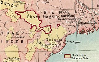
The Chota Nagpur Tributary States or Chota Nagpur States were a group of non-salute states at the time of British Raj, located on the Chota Nagpur Plateau. British suzerainty over the states was exercised through the government of the Bengal Presidency.

<span class="mw-page-title-main">Chhattisgarh Division</span> Administrative division of the Central Provinces of British India

Chhattisgarh Division was an administrative division of the Central Provinces of British India. It was located in the east of the Central Provinces and encompassed the upper Mahanadi River basin, in the central part of present-day Chhattisgarh state of India.

The region have been inhabited since the Stone Age. Copper tools from the Chalcolithic period have been discovered. This area entered the Iron Age during the mid-2nd millennium BCE.

<span class="mw-page-title-main">Saraikela State</span> Princely state of British India in modern-day Jharkhand

Saraikela State also spelt Seraikela, Saraikella or Seraikella, was a princely state in India during the era of the British Raj, in the region that is now the Jharkhand state. Its capital was at Saraikela.

<span class="mw-page-title-main">Orissa Province</span> Province of British India (1936–1947)

Orissa Province was a province of British India created in April 1936 by the partitioning of the Bihar and Orissa Province. Its territory corresponds with the modern-day State of Odisha.

<span class="mw-page-title-main">States Reorganisation Act, 1956</span> Indian act reforming state boundaries

The States Reorganisation Act, 1956 was a major reform of the boundaries of India's states and territories, organising them along linguistic lines.

The Bhanja dynasty is a dynasty that originated in the northern and central regions of modern Odisha before the Gupta Empire became an imperial power. The dynasty, of ancient local Kshatriya lineage as documented by Hermann Kulke, succeeded the Vindhyatabi branch of the Nagas of Padmavati, who ruled from the Keonjhar district of Odisha and included Satrubhanja of the Asanpat inscription. The Bhanj later became feudatories of the Bhauma-Kara dynasty.

<span class="mw-page-title-main">Mayurbhanj State</span> Princely state of British India in modern-day Odisha

Mayurbhanj State was one of the princely states of India during the period of the British Raj. It was one of the largest states of the Eastern States Agency and one of the three states of the Bengal States Agency. The emblem of the state were two peacocks for according to legend the ancestors of the ancient rulers originated from a peafowl's eyes.

<span class="mw-page-title-main">Ranpur State</span>

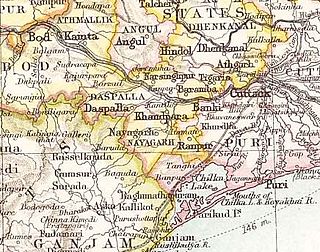
Ranpur State was one of many princely non-salute states of India during the period of the British Raj. It was one of the four native states located in present-day Nayagarh district, Odisha.

<span class="mw-page-title-main">Rairakhol State</span> Princely state in the British Raj

Rairakhol State was a princely state during the British Raj in what is today India. It was one of the Chota Nagpur States and had its capital at Rairakhol (Redhakhol), located in the present-day Sambalpur district of Odisha. It had an area of 2,157 square kilometres (833 sq mi) and a population of 26,888 in 1901, the average revenue was Rs.55,000 in 1904.

<span class="mw-page-title-main">Banki State</span>

Banki or Bānki State was a princely state in Odisha during the British Raj. Its capital was Banki, in the western part of present day Cuttack district.

<span class="mw-page-title-main">Bhoi dynasty</span> Medieval Odia Hindu dynasty

The Bhoi dynastywas a medieval Hindu dynasty from the Indian subcontinent, which originated in the region of Odisha that reigned from 1541 to 1560 CE. Govinda Vidyadhara had usurped the throne from the later weaker Suryavamsa Gajapati Empire rulers as the kingdom started weakening but had a short-lived reign as ruling chiefs of Odisha as the ensuing internal rivalries and constant threats of invasions rendered them weak and were eventually overthrown by Mukunda Deva of Chalukya dynasty in 1560.

Kujang Estate was a small zamindari or estate located on the northern coast of the present-day state of Odisha in India. It was founded by Mallik Sandha, a teacher who established the Sandha dynasty. According to several sources, the Kujang kings enthusiastically patronized and spread education in their lands and played an important role in the Indian Independence Movement in Odisha.

References

  1. Imperial Gazetteer of India, v. 19, p. 252.
  2. L. E. B. Cobden-Ramsay, Feudatory States of Orissa
  3. Baden-Powell, B. H. (2013). The Land Systems of British India (Vol. 1). London: Forgotten Books. (Original work published 1892) pp. 474–5.
  4. 1 2 3 Chisholm, Hugh, ed. (1911). "Orissa"  . Encyclopædia Britannica . Vol. 20 (11th ed.). Cambridge University Press. p. 277.
  5. Frederick George Bailey, Politics and Social Change: Orissa in 1959. p. 179