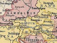
Baudh State

Last updated

Baudh State
Vassal state of Maratha Confederacy (1751 - 1804)
Princely State of British India
14th century–1948
Drapeau Baudh.png
Flag
SonpurKart.jpg
Baudh State in the Imperial Gazetteer of India
Area 
 1921
3,274 km2 (1,264 sq mi)
Population 
 1921
130,103
History 
 Established
14th century
1948
Succeeded by
India Flag of India.svg

Baudh State, also known as Boudh State, was one of the princely states of India during the British Raj. It was recognized as a state in 1874 and had its capital in Boudh town. Its last ruler signed the document of accession to the Indian Union on 1 January 1948.

Contents

History

According to traditions, after the fall of the Somavamshi dynasty to Eastern Gangas, local chieftains were installed in the region as feudatories. A childless Brahmin chieftain adopted the nephew of the neighbouring Raja of Keonjhar who belonged to the Bhanj dynasty. This prince styled himself Ananga Deva and founded the state in the 14th century. [1]

Maratha Rule

During the Maratha rule in Orissa, the territory of Boudh experienced a more direct Maratha influence than it had under Muslim rule, primarily due to its strategic location. The Maratha administration at Cuttack, controlled by the supreme government at Nagpur, frequently moved troops through the Barmul pass and other routes in western Orissa, making Boudh a critical link. The Raja of Boudh, like other regional rulers, paid tribute (peshkush) to the Maratha government and maintained amicable relations. When Maratha officers collecting peshkush at Sonepur were attacked, they fled to Boudh, where the Raja captured the insurgents and sent them to Nagpur, earning the Raja a prestigious title. However, relations soured in 1800 when Vyankoji, a Maratha leader, was snubbed by the Raja of Boudh, leading to a punitive Maratha invasion that subdued the Raja. Later, during the British invasion of Orissa, the Marathas retreated to the fort of Barabati at Cuttack and then to Boudh after the British captured the fort. The Raja of Boudh hesitated to submit to the British, observing the Maratha forces mobilizing at Barmul pass. After Major Farbes and his British force expelled the Marathas from Barmul, the Raja of Boudh submitted and entered a treaty with the East India Company on March 3, 1804. [2]

See also

Related Research Articles

<span class="mw-page-title-main">Bamra State</span>

Bamra State or Bamanda State, covering an area of 5,149 km2, was one of the princely states of India during the British Raj. Its capital was in Debagarh (Deogarh). Bamra State acceded to India in 1948.

<span class="mw-page-title-main">Boudh district</span> District of Odisha in India

Boudh District is an administrative and a municipal district, one of the thirty in the Odisha, India. The district headquarters of the Boudh District is the city of Boudh.

<span class="mw-page-title-main">History of Odisha</span> History of the Indian state of Odisha

The history of Odisha begins in the Lower Paleolithic era, as Acheulian tools dating to the period have been discovered in various places in the region. The early history of Odisha can be traced back to writings found in ancient texts like the Mahabharata, Maha Govinda Sutta and some Puranas. The region was also known to other kingdoms in region of East Indies due to maritime trade relations.

<span class="mw-page-title-main">Barabati fort</span> Fort in Cuttack

Barabati Fort is a 987 CE fort built by Marakata Keshari of Somavanshi (Keshari) dynasty in Cuttack, Odisha. The ruins of the fort remain with its moat, gate, and the earthen mound of the nine-storied palace.

<span class="mw-page-title-main">Patna State</span> Princely state of India

Patna State was a princely state in the Eastern States Agency of India during the British Raj. It had its capital at Balangir. Its area was 6,503 km2 (2,511 sq mi).

<span class="mw-page-title-main">Bonai State</span>

Bonai State was a minor princely state during the British Raj in what is today India. It was one of the Chota Nagpur States and had its capital at Bonaigarh, located in the present-day Sundergarh district of Odisha. It had an area of 8,907 square kilometres (3,439 sq mi) and a population of 24,026 in 1892 with an average annual revenue of Rs.60,000 in 1901.

<span class="mw-page-title-main">Baramba State</span>

Baramba State was one of the princely states of India during the British Raj. It had its capital in Baramba town. The last ruler acceded to the Indian Union on 1 January 1948. Baramba state was made part of Cuttack district of Odisha in 1948.

<span class="mw-page-title-main">Daspalla State</span> Princely state of India during the British Raj

Daspalla State was one of the princely states of India during the period of the British Raj. Its capital was Kunjabangarh, located in present-day Nayagarh district, Odisha.

<span class="mw-page-title-main">Sambalpur State</span>

Sambalpur State, also known as Hirakhand Kingdom, was a kingdom founded in 1570. It ruled over Western Odisha and Eastern Chhattisgarh in central-eastern India prior to the Maratha occupation in 1800 AD. From 1849 AD, it was integrated with British Raj as a British District. Its capital was present-day Sambalpur city in Western Odisha.

<span class="mw-page-title-main">Bhanja dynasty</span> Ancient dynasty originated in fhe Utkala Kingdom

The Bhanja dynasty is a dynasty that originated in the northern and central regions of modern Odisha before the Gupta Empire became an imperial power. The dynasty, of ancient local Kshatriya lineage as documented by Hermann Kulke, succeeded the Vindhyatabi branch of the Nagas of Padmavati, who ruled from the Keonjhar district of Odisha and included Satrubhanja of the Asanpat inscription. The Bhanj later became feudatories of the Bhauma-Kara dynasty.

<span class="mw-page-title-main">Nayagarh State</span>

Nayagarh State was one of the princely states of India during the British Raj. It was located in present-day Nayagarh district, Odisha.

<span class="mw-page-title-main">Keonjhar State</span>

Keonjhar State, also known as Keunjhar, was one of the princely states of India during the period of the British Raj. The second largest of the states of the Orissa States Agency, it was located in present-day Kendujhar district, Odisha.

<span class="mw-page-title-main">Narsinghpur State</span> Princely state of India before 1948

Narsinghpur State was one of the princely states of India during the British Raj. The state was founded in the 17th century and had its capital in Narasinghpur town. The last ruler of Narsinghpur joined the state to the Indian Union in 1948 and Narsinghpur state was made part of the Cuttack district of Odisha.

<span class="mw-page-title-main">Banki State</span>

Banki or Bānki State was a princely state in Odisha during the British Raj. Its capital was Banki, in the western part of present day Cuttack district.

Jagannatha Gajapati Narayana Deo II was the Odia monarch of the Paralakhemundi Estate in the southern part of today's Odisha and northern Andhra Pradesh. He was from the Eastern Ganga dynasty of the Khemundi Ganga Branch from the year 1736 CE to 1771 CE. He had ascended to the throne at the age of eighteen and at a time when Odisha was torn apart due conflicts between external powers like the Mughals, Marathas, French and British for control of the territory. He invaded khurdha Bhoi dynasty king Birakishore Deva and Vizianagaram estate King Pusapati Vijayarama Raju II and defeated the both kings. He made the last great attempts on his own to revive the lost glory of Odisha and its unique Hindu culture that revolved around the tradition of Jagannath worship. He had defied the authority of the Nizam of Hyderabad and maintained his own sovereignty. He was one of the first rulers who indulged in conflicts with the new European colonists in the eastern part of India. He was also effort bound till the end of his life in framing strategic diplomatic plans to free the ancient land of Odisha from external aggressors and revival of its lost Eastern Ganga Dynasty-Gajapati glory from the past.

<span class="mw-page-title-main">Tarakote Raj</span> Former Princely State in India

Tarakote formerly Shergarh-Tarakote Estate was a quasi princely state in Korei, Odisha which was established under the Mughal Empire as a Sarakaar and was later reduced to an intermediary princely estate during the subsequent Maratha and the British rule. Its capital was at Tarakote, in the western part of the present day Korei block.

<span class="mw-page-title-main">Bhoi dynasty</span> Medieval Odia Hindu dynasty

The Bhoi dynasty or the Yaduvamsa dynasty were a medieval Hindu dynasty from the Indian subcontinent, which originated in the region of Odisha that reigned from 1541 to 1560 CE. Govinda Vidyadhara had usurped the throne from the later weaker Suryavamsa Gajapati Empire rulers as the kingdom started weakening but had a short-lived reign as ruling chiefs of Odisha as the ensuing internal rivalries and constant threats of invasions rendered them weak and were eventually overthrown by Mukunda Deva of Chalukya dynasty in 1560.

Bhaskar Ram Kolhatkar, known as Baba Bhaskar Pandit by the people of Bengal, was a Maratha general and statesman. He was the dewan of the Maharaja of Nagpur, Raghuji Bhonsle. He played an important role in the kingdom of Nagpur's expansion. The first Maratha invasion of Bengal in 1741, as also the third in 1744, was led by him. He was an able military leader, proven by his success in the Maratha invasions of Bengal and conquest of Chhattisgarh. He was killed by Alivardi Khan on 30 March 1744.

Kujang Estate was a small zamindari or estate located on the northern coast of the present-day state of Odisha in India. It was founded by Mallik Sandha, a teacher who established the Sandha dynasty. According to several sources, the Kujang kings enthusiastically patronized and spread education in their lands and played an important role in the Indian Independence Movement in Odisha.

References

  1. ODISHA DISTRICT GAZETTEERS BOUDH (PDF), GAD, Govt of Odisha, 1991, p. 23
  2. Senapati, Nilamani; Kuanr, Durge Charan. Orissa district gazetteers : Boudh-Khondmals. Gazetters Unit, Orissa. p. 37-38.

20°50′N84°19′E / 20.84°N 84.32°E / 20.84; 84.32