Saraikella State | |||||||
---|---|---|---|---|---|---|---|
Princely State of British India | |||||||
Flag | |||||||
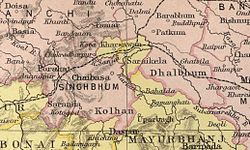
![]() Saraikela State in a 1909 Imperial Gazetteer of India map | |||||||
Capital | Saraikela | ||||||
Area | |||||||
• 1892 | 1,163 km2 (449 sq mi) | ||||||
• 1901 | 1,162 km2 (449 sq mi) | ||||||
• 1941 | 1,210 km2 (470 sq mi) | ||||||
Population | |||||||
• 1872 | 66,347 | ||||||
• 1891 | 93,839 | ||||||
• 1901 | 104,539 | ||||||
• 1941 | 154,844 | ||||||
History | |||||||
• Established | 1620 | ||||||
15 August 1947 | |||||||
13 December 1948 | |||||||
• Merged with Bihar | 1 August 1949 | ||||||
| |||||||
Today part of | Saraikela Kharsawan district, Jharkhand |
Saraikela State also spelt Seraikela, Saraikella or Seraikella, was a small princely state in India during the British Raj, in what is now the Seraikela-Kharsawan district of the Jharkhand state. [2] [3] Its capital was at Saraikela.
The state had an area of 1163 km2 which yielded an average revenue of Rs. 92,000 in 1901, and was one of the nine Chota Nagpur States, a group of small, non-salute states (minor princely states), under the authority of the governor of Bengal Presidency. [4] The last ruler of the state, Raja Aditya Pratap Singh Deo, signed the merger agreement acceding to the Indian Union on 18 May 1948.
The state was founded in 1620 by Raja Bikram Singh, from Rathore clan of Rajputs. The state came under the influence of the Maratha rulers of Nagpur in the 18th century, and became a princely state of British India in 1803, at the conclusion of the Second Anglo-Maratha War at Deogaon of Orissa. After the war, the East India Company included the Saraikela princely state under the governance of the Chhota Nagpur Commissioner.[ citation needed ]
In 1912 Saraikela came under the authority of the province of Bihar and Orissa, which was newly created from the eastern districts of Bengal. In 1936 the state was placed under the authority of the Orissa Province.
Saraikela, along with 24 other princely states of the Eastern States Agency, acceded to the Government of India on 1 January 1948, with a will to merge the princely state with Orissa province of the Indian Republic.
As a result, both Saraikela and Kharsawan princely states were merged with Orissa in 1948. On 1 January 1948 itself, the tribals of these two princely states, who were in a majority, revolted against the merger with Orissa. This was supported by Patayet Sahib Maharajkumar Bhoopendra Narayan Singh Deo, third son of Raja Aditya , as a result of which he was imprisoned to ensure the popular movement died down. The central government appointed a commission under Mr. Baudkar to look into the matter. On the basis of the Baudkar commission report, Saraikela and Kharsawan princely states were merged with Bihar on 18 May 1948.
These two princely states became part of Jharkhand when the state was carved out of Bihar on 15 November 2000. From 18 May 1948 onward, many non-tribal Oriyas of the districts of Saraikela Kharsawan, East Singhbhum, and West Singhbhum have migrated and settled permanently in Odisha.
Year | Pop. | ±% |
---|---|---|
1891 | 93,839 | — |
1901 | 104,539 | +11.4% |
1911 | 109,794 | +5.0% |
1921 | 115,192 | +4.9% |
1931 | 143,525 | +24.6% |
1941 | 154,844 | +7.9% |
Source: Census of British India [5] |
According to the 1941 Census, the Seraikela State covered an area of 466 square miles (1,210 km2) and had a population of 154,844. Tribal religious beliefs were practiced by 51.95% of the population, followed by Hinduism at 46.8%, Islam at 1.21%, and a combined 0.04% identifying as Sikh or Jain. The state was primarily inhabited by tribal communities, including Santal (20.78%), Ho (15.18%), Bhumij (7.11%), Munda (1.43%), Oraon (0.57%), Mahli (0.5%), and Gond (0.02%). The overall literacy rate stood at 6.39%, with 8,948 literate males and 946 literate females. [5]
According to the 1931 Census of India, the state of Seraikela covered 449 square miles (1,160 km2) and had a population of 143,525, and the neighboring state of Kharsawan comprised 153 square miles (400 km2) with 43,097 inhabitants, bringing the total population of the two states to 186,622 over 602 square miles (1,560 km2). Among this population, 27.44% (51,206) spoke Odia, followed by Bengali at 24.31% (45,364), Ho at 18.44% (34,407), Santali at 16.49% (30,767), Hindustani at 5.48% (10,226), Mundari at 3.36% (6,277), Bhumij at 3.24% (6,038), and Oraon at 0.55% (1,035), and the rest 0.70% (1,302) spoke others languages. [6]
The rulers were Rajputs of the Rathore clan and bore the title of 'Kunwar' until 1884. [7] The rulers are descendants of the Porahat royal family.