
The Central Provinces and Berar was a province of British India and later the Dominion of India which existed from 1903 to 1950. It was formed by the merger of the Central Provinces with the province of Berar, which was territory leased by the British from the Hyderabad State. Through an agreement signed on 5 November 1902, 6th Nizam Mahbub Ali Khan, Asaf Jah VI leased Berar permanently to the British for an annual payment of 25 lakhs rupees. Lord Curzon decided to merge Berar with the Central Provinces, and this was proclaimed on 17 September 1903.

Korea State, currently spelt as Koriya, was a small princely state in the British Empire of India. After Indian independence in 1947, the ruler of Korea acceded to the Union of India on 1 January 1948, and Koriya was made part of Surguja District of Central Provinces and Berar province. In January 1950, "Central Provinces and Berar" province was renamed Madhya Pradesh state. After November 2000, Korea and the former princely state of Changbhakar became Koriya district of Chhattisgarh state.

Rajnandgaon is a district of the state of Chhattisgarh in central India. The administrative headquarters the district is Rajnandgaon town.
The Eastern States Agency was an agency or grouping of princely states in eastern India, during the latter years of the British Raj. It was created in 1933, by the unification of the former Chhattisgarh States Agency and the Orissa States Agency; the agencies remained intact within the grouping. In 1936, the Bengal States Agency was added.

Kawardha is a town and a municipality in Kabirdham district in the Indian state of Chhattisgarh. It is the administrative headquarters of Kabirdham district. Kawardha is also known for the "Temple of Bhoramdeo."
Sarangarh is a New District in the Indian state of Chhattisgarh.
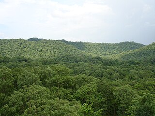
Kabirdham district is one of the 33 administrative districts of Chhattisgarh state in central India. The district was earlier known as Kawardha district. The district is located between 21.32' to 22.28' north latitude and 80.48' to 81.48' east longitude. The district covers an area of 4,447.5 km2 (1,717.2 sq mi). The city of Kawardha is its administrative headquarters. This district is known for the Bhoramdeo temple located at a distance of 18 km from the district headquarters, Kawardha.

Changbhakar State, also known as Chang Bhakar, was one of the small princely states of British Empire in India in the Chhattisgarh States Agency. It included 117 villages and had an area of 2,330 square kilometres (899 sq mi) with a 1941 population of 21,266 people. Bharatpur was the capital of the princely state.
Sakti State was one of the princely states of India during the British Raj. It belonged to the Chhattisgarh States Agency, which later became the Eastern States Agency.

Bikaner State was the Princely State in the north-western most part of the Rajputana province of imperial British India from 1465 to 1947. The founder of the state Rao Bika was a younger son of Rao Jodha ruler of and founder of the city of Jodhpur in Marwar. Rao Bika chose to establish his own kingdom instead of inheriting his father's. Bika defeated the Jat clans of Jangladesh which today refers to the north and north-western Rajasthan along with his uncle Rao Kandhal and his adviser Vikramji Rajpurohit and founded his own kingdom. Its capital was the city of Bikaner.
Maharaja Dharamraj Singh was the Raja of the princely state of Kawardha State from 1920 till 1948, when the Kawardha merged into Union of India. He later became active politician of Indian National Congress.

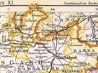
Raigarh was a princely state in India during the British Raj. The state was ruled by the Gond dynasty of Gond clan.

Khairagarh State was one of the princely states of India during the period of the British Raj. Khairagarh town in Khairagarh-Chhuikhadan-Gandai district of Chhattisgarh was the capital of the state and the seat of the Raja's residence.

Kharsawan State, also spelt Kharsua or kharaswan, (Odia:ଖରସୁଆଁ) was a princely state in India during the British Raj. The state had a privy purse of 33,000 rupees. It was one of the Odia Princely states of India during the period of the British Raj and the major language spoken in the area is Odia.

Surguja State was one of the main princely states of Central India during the period of the British Raj, even though it was not entitled to any gun salute. Formerly, it was placed under the Central India Agency, but in 1905 it was transferred to the Eastern States Agency.

Sarangarh was a princely state in India during the British Raj ruled by a Raj Gond dynasty. The emblem of the state was a turtle.

Jashpur State was one of the princely states of India during the British Raj. The town of Jashpur was the former state's capital. The rulers were Rajputs of the Chauhan clan.

Kanker State was one of the princely states of India during the period of the British Raj. Its last ruler, Maharajadhiraj Bhanu Pratap Deo, signed the accession to the Indian Union in 1947.
Kawardha is one of the 90 Legislative Assembly constituencies of Chhattisgarh state in India. It is in Kabirdham district and is a segment of Rajnandgaon Lok Sabha seat. The seat used to be part of Madhya Pradesh Legislative Assembly when Chhattisgarh was part of MP.

