Chota Nagpur Tributary States

Last updated

Chota Nagpur Tributary States
Group of princely states of British India
1821–1947
Chota Nagpur States-IGI 2.jpg
Area 
 1881
41,580 km2 (16,050 sq mi)
Population 
 1881
678,002
History 
  Sanads issued to Chota Nagpur rulers
1821
1947
Preceded by
Succeeded by
Flag of the British East India Company (1801).svg Agencies of British India
India Flag of India.svg
Today part of Chhattisgarh, Jharkhand and Odisha
Chota Nagpur States; group under the Chhattisgarh States Agency Chota Nagpur States-a.jpg
Chota Nagpur States; group under the Chhattisgarh States Agency
Chota Nagpur States; group under the Orissa States Agency Chota Nagpur States-b.jpg
Chota Nagpur States; group under the Orissa States Agency

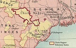
The Chota Nagpur Tributary States [1] or Chota Nagpur States were a group of small, non-salute states (minor princely states) during the British Raj in India, located on the Chota Nagpur Plateau. British suzerainty over the states was exercised through the government of the Bengal Presidency.

Contents

These states were nine in number and became part of the Indian states of Madhya Pradesh, Bihar and Odisha following Indian Independence. [2]

History

In the 18th century, the states came within the sphere of influence of the Maratha Empire, but they became tributary states of British India as a result of the Anglo-Maratha Wars in the early 19th century.

In October 1905, the exercise of British influence over the predominantly Hindi-speaking states of Chang Bhakar, Jashpur, Koriya, Surguja, and Udaipur was transferred from the Bengal government to that of the Central Provinces, while the two Oriya-speaking state Gangpur and Bonai were attached to the Orissa Tributary States, leaving only Kharsawan and Saraikela answerable to the Bengal governor. [3]

In 1936, all nine states were transferred to the Eastern States Agency, the officials of which came under the direct authority of the Governor-General of India, rather than under that of any provinces.

After Indian independence in 1947, the rulers of these minor princely states all chose to accede to the Dominion of India. Changbhakar, Jashpur, Koriya, Surguja and Udaipur later became part of Madhya Pradesh state, Gangpur and Bonai part of Orissa state, and Kharsawan and Saraikela part of Bihar state. [4]

In November 2000, the new states of Chhattisgarh and Jharkhand were separated from Madhya Pradesh and Bihar, respectively.

Princely States

The following princely states were collectively called 'Chhota Nagpur Tributary States' :

See also

Related Research Articles

<span class="mw-page-title-main">Central Provinces and Berar</span> Province of British India, and later, Dominion of India (1903–1950)

The Central Provinces and Berar was a province of British India and later the Dominion of India which existed from 1903 to 1950. It was formed by the merger of the Central Provinces with the province of Berar, which was territory leased by the British from the Hyderabad State. Through an agreement signed on 5 November 1902, 6th Nizam Mahbub Ali Khan, Asaf Jah VI leased Berar permanently to the British for an annual payment of 25 lakhs rupees. Lord Curzon decided to merge Berar with the Central Provinces, and this was proclaimed on 17 September 1903.

<span class="mw-page-title-main">Singhbhum district</span> District of British India of Bengal Presidency

Singhbhum was a district of India during the British Raj, part of the Chota Nagpur Division of the Bengal Presidency. It was located in the present-day Indian state of Jharkhand. Chaibasa was the district headquarters. Located in the southern limit of the Chota Nagpur Plateau, Singhbhum included the Kolhan estate located in its southeastern part. The district has been segmented into two smaller districts, East Singhbhum and West Singhbhum.

<span class="mw-page-title-main">Korea State</span>

Korea State, currently spelt as Koriya, was a small princely state inthe British Empire of India. After Indian independence in 1947, the ruler of Korea acceded to the Union of India on 1 January 1948, and Koriya was made part of Surguja District of Central Provinces and Berar province. In January 1950, "Central Provinces and Berar" province was renamed Madhya Pradesh state. After November 2000, Korea and the former princely state of Changbhakar became Koriya district of Chhattisgarh state.

<span class="mw-page-title-main">Eastern States Agency</span> Agency of India from 1933 to 1947

The Eastern States Agency was an agency or grouping of princely states in eastern India, during the latter years of the British Raj. It was created in 1933, by the unification of the former Chhattisgarh States Agency and the Orissa States Agency; the agencies remained intact within the grouping. In 1936, the Bengal States Agency was added.

<span class="mw-page-title-main">Central Provinces</span> Province of British India

The Central Provinces was a province of British India. It comprised British conquests from the Mughals and Marathas in central India, and covered parts of present-day Madhya Pradesh, Chhattisgarh and Maharashtra states. Nagpur was the primary winter capital while Pachmarhi served as the regular summer retreat. It became the Central Provinces and Berar in 1903.

<span class="mw-page-title-main">Chota Nagpur Division</span>

Chota Nagpur Division, also known as the South-West Frontier, was an administrative division of British India. It included most of the present-day state of Jharkhand as well as adjacent portions of West Bengal, Orissa, and Chhattisgarh.

<span class="mw-page-title-main">Orissa Tributary States</span> Group of princely states in Odisha, India

The Orissa Tributary States, also known as the Garhjats and as the Orissa Feudatory States, were a group of princely states of British India now part of the present-day Indian state of Odisha.

<span class="mw-page-title-main">Chhattisgarh Division</span> Administrative division of the Central Provinces of British India

Chhattisgarh Division was an administrative division of the Central Provinces of British India. It was located in the east of the Central Provinces and encompassed the upper Mahanadi River basin, in the central part of present-day Chhattisgarh state of India.

<span class="mw-page-title-main">Changbhakar</span>

Changbhakar State, also known as Chang Bhakar, was one of the small princely states of British Empire in India in the Chhattisgarh States Agency. It included 117 villages and had an area of 2,330 square kilometres (899 sq mi) with a 1941 population of 21,266 people. Bharatpur was the capital of the princely state.

The region have been inhabited since the Stone Age. Copper tools from the Chalcolithic period have been discovered. This area entered the Iron Age during the mid-2nd millennium BCE.

<span class="mw-page-title-main">Saraikela State</span> Princely state of British India in modern-day Jharkhand

Saraikela State also spelt Seraikela, Saraikella or Seraikella, was a small princely state in India during the British Raj, in the region that is now the Jharkhand state. Its capital was at Saraikela.

<span class="mw-page-title-main">Surajpur district</span> District In Chhattisgarh, India

Surajpur district is a district in the state of Chhattisgarh in central India, with its administrative headquarters at Surajpur. National Highway 43 passes through Surajpur district. Surajpur was declared a district on 15 August 2011 along with eight other new districts. Surajpur is the first district to receive National Satyan Maitra Literacy Award. The district is known for its market and other major tourist places of Chhattisgarh with Tamor Pingla Wildlife Sanctuary.

<span class="mw-page-title-main">Udaipur State, Chhattisgarh</span> Princely state in Chhattisgarh, India

Udaipur State was one of the princely states of India during the period of the British Raj. The town of Dharamjaigarh was the former state's capital.

<span class="mw-page-title-main">Kharsawan State</span> Princely state of the British Raj

Kharsawan State, also spelt Kharsua or kharaswan, (Odia:ଖରସୁଆଁ)was a princely state in India during the British Raj. The state had a privy purse of 33,000 rupees. It was one of the Odia Princely states of India during the period of the British Raj and the major language spoken in the area is Odia.

<span class="mw-page-title-main">Surguja State</span> Princely state of Central India

Surguja State was one of the main princely states of Central India during the period of the British Raj, even though it was not entitled to any gun salute. Formerly, it was placed under the Central India Agency, but in 1905 it was transferred to the Eastern States Agency.

<span class="mw-page-title-main">Jashpur State</span>

Jashpur State was one of the princely states of India during the period of the British Raj. The town of Jashpur was the former state's capital. The rulers were Rajputs of Chauhan Clan.

<span class="mw-page-title-main">Rairakhol State</span> Princely state in the British Raj

Rairakhol State was a princely state during the British Raj in what is today India. It was one of the Chota Nagpur States and had its capital at Rairakhol (Redhakhol), located in the present-day Sambalpur district of Odisha. It had an area of 2,157 square kilometres (833 sq mi) and a population of 26,888 in 1901, the average revenue was Rs.55,000 in 1904.

<span class="mw-page-title-main">Eastern States Union</span>

The Eastern States Union was a short-lived (1947–48) union of princely states in newly independent India that gathered most of the princely states of the former Orissa Tributary States and Chhattisgarh States Agency in order to fill the vacuum of power created after the departure of the British and the wrapping up of the British Raj.

References

  1. Chota Nagpur Tributary States Gazetteer. Statistics, 1901-02
  2. A. K. Lal (ed.), Social Exclusion: Essays in Honour of Dr. Bindeshwar Pathak, Volume 1; p. 330
  3. Hunter, William Wilson, Sir, et al. (1908). Imperial Gazetteer of India , Volume 12. 1908-1931; Clarendon Press, Oxford
  4. Eastern States Agency. List of ruling chiefs & leading personages Delhi: Agent to Governor-General, Eastern States, 1936