Nayagarh State

Last updated

Nayagarh State
Princely State of British India
1480–1948
Daspalla-Nayagarh-Imperial Gazetteer.jpg
Nayagarh State in the Imperial Gazetteer of India
Area 
 1931
1,528 km2 (590 sq mi)
Population 
 1931
142,406
  TypeOdisha government
History 
 Established
1480
1948
Succeeded by
India Flag of India.svg

Nayagarh State was one of the princely states of India from the period of the British Raj. [1] It was located in present-day Nayagarh district, Odisha.

Contents

The state was bounded in the north by Khandpara State and Puri District. The capital was at Nayagarh. The southern part of the state was forested and mountainous and was inhabited mainly by Khonds. [2]

History

According to traditions, Nayagarh state was alleged to have been founded by a scion from the Rewa State before 15th century, but lack of written archival historical records marks them as untenable due to the non-alignment of timelines of both Nayagarh and its collateral Khandpara state with that of the corresponding Rewa state which was founded in 1618 succeeding from Bandhavgarh kingdom, which possibly points to its legendary origins due to the historical obscurity. [3] None of the chiefs of Nayagarh appear to have received farmans from both Mughals and Marathas until when the Bhonsle Maharaja of Nagpur Raghoji I Bhonsle gifted the chiefs for his assistance during the Maratha conquest of Orissa. [4] Although it is likely that a local chieftain by the name Baghel Singh (1480-1510 CE) who is reputed to be the founder of Nayagarh, as it was known as Baghua Nayagarh, may likely be the founder of the state and also the progenitor of the dynasty with the same name. [5] [6] [7]

Under Raghunath Singh's (1565-1595) successors Khandpara State which was initially part of Nayagarh State became a separate kingdom in 1599 with his younger son Jadunath Singh inheriting Khandpara while his elder son Harihar Singh continuing at Nayagarh. [5]

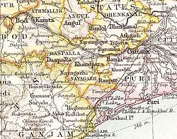
The last ruler signed the instrument of accession to the Indian Union on 1 January 1948, merging his state into Odisha forming a part of the Nayagarh district.

Rulers

The rulers of Nayagarh State bore the title of Raja. The emblem of the Nayagarh royal family was the head of a tiger, the same state symbol as that of the rulers in neighbouring Khandpara State.

Titular

Krushna Chandra Singh Mandhata

Amarendra Kishore Singh Mandata

Rameswar Prasad Singh Mandata (present)

See also

Related Research Articles

<span class="mw-page-title-main">Nayagarh</span> Town in Odisha, India

Nayagarh is both a town and the municipality headquarters of the Nayagarh district in the Indian state of Odisha.

<span class="mw-page-title-main">Orissa Tributary States</span> Group of princely states in Odisha, India

The Orissa Tributary States, also known as the Garhjats and as the Orissa Feudatory States, were a group of princely states of British India now part of the present-day Indian state of Odisha.

<span class="mw-page-title-main">Dharakot</span> Village in Odisha, India

Dharakot is a semi-urban village and former zamindari estate in Dharakot Block of Ganjam district in the Indian state of Odisha.

<span class="mw-page-title-main">Nilgiri State</span>

Nilagiri State was one of the Princely States of India during the British Raj. It belonged to the Orissa States Agency and its capital was at Raj Nilgiri, which is the modern town of Nilagiri.

<span class="mw-page-title-main">Gangpur State</span> Former Indian State

Gangpur State, also known as Gangpore State, was one of the princely states of India during the period of the British Raj. Until 1905 it was one of the Chhota Nagpur States under the Eastern States Agency.

<span class="mw-page-title-main">Hindol State</span>

Hindol State was one of the princely states of India during the period of the British Raj. Its former territory is now part of Dhenkanal district. The state's former capital was the town of Hindol, Odisha. Until 1947, it was not part of British India but was subject to the suzerainty of the British crown, under the Orissa States Agency.

Sundargarh is a Vidhan Sabha constituency of Sundergarh district. Area of this constituency includes Sundargarh, Sundargarh block, Tangarpali block, Hemgiri block and seven Gram panchayats of Lephripada block.

Daspalla is a Vidhan Sabha constituency of Nayagarh district, Odisha.

Khandapada is a Vidhan Sabha constituency of Nayagarh district, Odisha.

Nayagarh is a Vidhan Sabha constituency of Nayagarh district, Odisha.

<span class="mw-page-title-main">Talcher State</span>

Talcher State was one of the princely states of India during the period of the British Raj. Talcher town in Angul District was the capital of the state and the seat of the Raja's residence. Its last ruler signed the accession to the Indian Union in 1948.

<span class="mw-page-title-main">Sambalpur State</span>

Sambalpur State, also known as Hirakhand Kingdom was a kingdom founded in 1570. It ruled over Western Odisha and Eastern Chhattisgarh in central-eastern India prior to the Maratha occupation in 1800 AD. From 1849 AD it was integrated with British Raj as a British District. Its capital was present-day Sambalpur city in Western Odisha.

<span class="mw-page-title-main">Bhanja dynasty</span> Ancient dynasty originated in fhe Utkala Kingdom

The Bhanja dynasty is a dynasty that originated in the northern and central regions of modern Odisha before the Gupta Empire became an imperial power. The dynasty, of ancient local Kshatriya lineage as documented by Hermann Kulke, succeeded the Vindhyatabi branch of the Nagas of Padmavati, who ruled from the Keonjhar district of Odisha and included Satrubhanja of the Asanpat inscription. The Bhanj later became feudatories of the Bhauma-Kara dynasty.

<span class="mw-page-title-main">Mayurbhanj State</span> Princely state of British India in modern-day Odisha

Mayurbhanj State was one of the princely states of India during the period of the British Raj. It was one of the largest states of the Eastern States Agency and one of the three states of the Bengal States Agency. The emblem of the state were two peacocks for according to legend the ancestors of the ancient rulers originated from a peafowl's eyes.

<span class="mw-page-title-main">Khandpara State</span> Princely state in Odisha, India

Khandpara State was one of the princely states of India during the period of the British Raj. It was located in present-day Nayagarh district, Odisha.

<span class="mw-page-title-main">Ranpur State</span>

Ranpur State was one of many princely non-salute states of India during the period of the British Raj. It was one of the four native states located in present-day Nayagarh district, Odisha.

<span class="mw-page-title-main">Tigiria State</span> State in India

Tigiria State was one of the princely states of India during the period of the British Raj. It was located in present-day Tigiria block of Cuttack district, Odisha. Although it was the smallest of the states of the Orissa States Agency it was the most densely populated. The last ruler of Tigiria joined the state to the Indian Union in 1948.

<span class="mw-page-title-main">Paralakhemundi Estate</span>

Parlakhemundi estate was a Zamindari of Odisha in the British Raj period .Before odisha province formation it was under Madras Presidency.The state was ruled as an independent kingdom till 1769.The royal family belong to the Krishnatreya gotra Odia Kshatriya and traced their lineage to Eastern Ganga Dynasty.It was a zamindari estate lying in the southwestern portion of Ganjam district, covering an area of 615 square miles. It was bounded in the south by the district of Vizagpatnam and on the west by the Jeypore Estate and the tribal agencies of the Eastern Ghats.

<span class="mw-page-title-main">Kaptipada Estate</span>

Kaptipada estate was one of the princely states of India during the period of the British Raj. It was located in eastern India and surrounded by Mayurbhanj state in north and west, Nilgiri state in east and Keonjhar state in south. The state was believed to founded by Naga Chief Phanimukuta during the rule of Gajapati ruler Kapileswar Dev about the middle of 15th century A.D.

References

  1. Chisholm, Hugh, ed. (1911). "Nayagarh"  . Encyclopædia Britannica . Vol. 19 (11th ed.). Cambridge University Press. p. 318.
  2. Great Britain India Office. The Imperial Gazetteer of India . Oxford: Clarendon Press, 1908.
  3. Hermann Kulke (1976), Kshatriyaization and social change: A Study in Orissa setting (PDF), Popular Prakashan, p. 404
  4. Cobden Ramsay (1910), Bengal Gazetteers Feudatory States Of Orissa, DLI, p. 263
  5. 1 2 District Survey Report Nayagarh (PDF), MoEF & CC, 25 July 2018, pp. 1–2
  6. ODISHA DISTRICT GAZETTEERS NAYAGARH (PDF), GAD, Govt of Odisha, 2015, p. 44
  7. Imperial Gazetteer of India, v. 18, p. 436.

20°08′N85°06′E / 20.13°N 85.1°E / 20.13; 85.1