Khandpara State

Last updated

Khandpara State
Princely State of British India
1599–1948
Flag of Khandpara.png
Flag
Daspalla-Nayagarh-Imperial Gazetteer.jpg
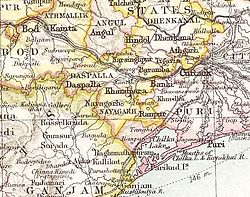
Khandpara State in the Imperial Gazetteer of India
Area 
 1901
632 km2 (244 sq mi)
Population 
 1901
77929
History 
 Established
1599
1948
Succeeded by
India Flag of India.svg

Khandpara State was one of the princely states of India during the period of the British Raj. It was located in present-day Nayagarh district, Odisha.

Contents

The state was bounded in the north by the Mahanadi River. The main town was Kantilo, but the capital was at Khandpara (Khandapada). [1]

History

Khandpara State is said to be founded by Jadunath Singh Mangaraj, the youngest son of Raja Raghunath Singh of Nayagarh, who retained possession of four Garhs or forts, as his share, viz. Kadua, Ghuntasahi, Saradhapur, and Khedapada, which are located in Nayagarh region. Jadunath Singh is also said to have received the title Mangaraj from the Gajapati Maharaja. In the reign of Raja Narayan Singh Mangraj, Khandpara extended on the east up to Banki, on the west to Balaramprasad in Daspalla, on the north to Kantilo, and on the south up to Jogiapali. [2] [3] [4]

The last ruler signed the instrument of accession to the Indian Union on 1 January 1948, merging his state into Odisha forming a part of the Nayagarh district.

Rulers

The rulers of Khandpara State bore the title of Raja. The emblem of the Khandpara royal family was the head of a tiger; state symbols were identical in neighboring Nayagarh State. [5]

Titular

See also

Related Research Articles

<span class="mw-page-title-main">Nayagarh</span> Town in Odisha, India

Nayagarh is both a town and the municipality headquarters of the Nayagarh district in the Indian state of Odisha.

<span class="mw-page-title-main">Dhenkanal State</span> Princely state in Odisha, India

Dhenkanal State was one of the princely states of India during the period of the British Raj. The state is now referred to as Dhenkanal district, Odisha, with Dhenkanal town as its district headquarters.

Khandapada is a town and a notified area committee in Nayagarh district in the Indian state of Odisha. It is located in the valley of nine mountains.

<span class="mw-page-title-main">Athgarh State</span>

Athgarh (ଆଠଗଡ) was one of the princely states of India during the period of the British Raj. The state was founded by Raja SriKaran Niladri Bebarta Patnaik in 1178 and had its capital in Athgarh (Athagad) town. It was made part of Cuttack district after its merger into the state of Odisha in 1948. The emblem of the state was Radha Krishna.

<span class="mw-page-title-main">Patna State</span> Princely state of India

Patna State was a princely state in the Eastern States Agency of India during the British Raj. It had its capital at Balangir. Its area was 6,503 km2 (2,511 sq mi).

<span class="mw-page-title-main">Saraikela State</span> Princely state of British India in modern-day Jharkhand

Saraikela State also spelt Seraikela, Saraikella or Seraikella, was a princely state in India during the era of the British Raj, in the region that is now the Jharkhand state. Its capital was at Saraikela.

<span class="mw-page-title-main">Bikaner State</span> Princely state of India

Bikaner State was a princely state in the Rajputana from 1465 to 1947. The founder of the state, Rao Bika, was the eldest son of Rao Jodha, ruler of Jodhpur. Rao Bika chose to build his own kingdom instead of inheriting his father's. Bika defeated the Jat clans of Jangladesh along with his uncle Rao Kandhal and his adviser Vikramji Rajpurohit and founded his own kingdom. Its capital was the city of Bikaner in the northern area of present-day Rajasthan State in India. Karni Mata has been designated as the kuldevi of the Royal family of Bikaner.

<span class="mw-page-title-main">Hindol State</span>

Hindol State was one of the princely states of India during the period of the British Raj. Its former territory is now part of Dhenkanal district. The state's former capital was the town of Hindol, Odisha. Until 1947, it was not part of British India but was subject to the suzerainty of the British crown, under the Orissa States Agency.

<span class="mw-page-title-main">Kalahandi State</span> Princely state of India

Kalahandi State, also known as Karond State, was one of the princely states of India during the period of the British Raj. It was recognized as a state in 1874 and had its capital in Bhawanipatna. Its last ruler signed the accession to the Indian Union on 1 January 1948. The present titular head of the state is Anant Pratap Deo who resides in the Kalahandi Palace in Bhawanipatna

<span class="mw-page-title-main">Talcher State</span>

Talcher State was one of the princely states of India during the period of the British Raj. Talcher town in Angul District was the capital of the state and the seat of the Raja's residence. Its last ruler signed the accession to the Indian Union in 1948.

<span class="mw-page-title-main">Kharsawan State</span> Princely state of the British Raj

Kharsawan State, also spelt Kharsua or kharaswan, (Odia:ଖରସୁଆଁ)was a princely state in India during the era of the British Raj. The state had a privy purse of 33,000 Rs.It was one of the Odia Princely states of India during the period of the British Raj and the major language spoken in the area is Odia.

<span class="mw-page-title-main">Daspalla State</span> Princely state of India during the British Raj

Daspalla State was one of the princely states of India during the period of the British Raj. Its capital was Kunjabangarh, located in present-day Nayagarh district, Odisha.

<span class="mw-page-title-main">Nayagarh State</span>

Nayagarh State was one of the princely states of India from the period of the British Raj. It was located in present-day Nayagarh district, Odisha.

<span class="mw-page-title-main">Ranpur State</span>

Ranpur State was one of many princely non-salute states of India during the period of the British Raj. It was one of the four native states located in present-day Nayagarh district, Odisha.

<span class="mw-page-title-main">Keonjhar State</span>

Keonjhar State, also known as Keunjhar, was one of the princely states of India during the period of the British Raj. The second largest of the states of the Orissa States Agency, it was located in present-day Kendujhar district, Odisha.

<span class="mw-page-title-main">Narsinghpur State</span> Princely state of India before 1948

Narsinghpur State was one of the princely states of India during the period of the British Raj. The state was founded in the 17th century and had its capital in Narasinghpur town. The last ruler of Narsinghpur joined the state to the Indian Union in 1948 and Narsinghpur state was made part of the Cuttack district of Odisha.

<span class="mw-page-title-main">Tigiria State</span> State in India

Tigiria State was one of the princely states of India during the period of the British Raj. It was located in present-day Tigiria block of Cuttack district, Odisha. Although it was the smallest of the states of the Orissa States Agency it was the most densely populated. The last ruler of Tigiria joined the state to the Indian Union in 1948.

<span class="mw-page-title-main">Paralakhemundi Estate</span>

Parlakhemundi estate was a Zamindari of Odisha in the British Raj period .Before odisha province formation it was under Madras Presidency.The state was ruled as an independent kingdom till 1769.The royal family belong to the Krishnatreya gotra Odia Kshatriya and traced their lineage to Eastern Ganga Dynasty.It was a zamindari estate lying in the southwestern portion of Ganjam district, covering an area of 615 square miles. It was bounded in the south by the district of Vizagpatnam and on the west by the Jeypore Estate and the tribal agencies of the Eastern Ghats.

References

  1. Great Britain India Office. The Imperial Gazetteer of India . Oxford: Clarendon Press, 1908.
  2. ODISHA DISTRICT GAZETTEERS NAYAGARH (PDF), GAD, Govt of Odisha, 2015, p. 44
  3. Cobden Ramsay (1910), Bengal Gazetteers Feudatory States Of Orissa, DLI, p. 232
  4. Imperial Gazetteer of India, v. 15, p. 247.
  5. Princely States of India

20°15′50″N85°12′51″E / 20.26389°N 85.21417°E / 20.26389; 85.21417