
Boudh District is an administrative and municipal district, one of thirty in the Odisha, India. The district headquarters is the city of Boudh.
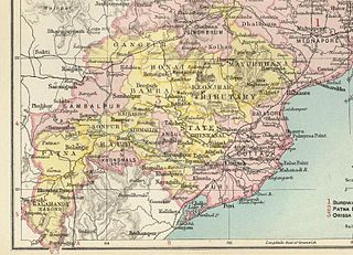
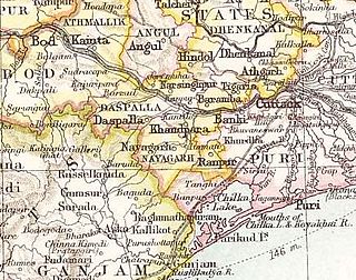
The Orissa Tributary States, also known as the Gadajats (ଗଡ଼ଜାତ) and as the Orissa Feudatory States, were a group of princely states of British India now part of the present-day Indian state of Odisha.

Dhenkanal State was one of the princely states of India during the period of the British Raj. The area of the former state is now referred to as Dhenkanal district, Odisha, with Dhenkanal town as its district headquarters.

Kendujhar district, also known as Keonjhar district, is an administrative district of Odisha. The district is one of the fifth Scheduled Areas of Odisha. The town of Kendujhar is the district headquarters. The district has three sub-divisions, Anandapur, Champua, and Kendujhar.
Gangpur State, also known as Gangpore State, was one of the princely states of India during the period of the British Raj. Until 1905 it was one of the Chhota Nagpur States under the Eastern States Agency.

Hindol State was one of the princely states of India during the British Raj. Its former territory is now part of Dhenkanal district. The state's former capital was the town of Hindol, Odisha. Until 1947, it was not part of British India but was subject to the suzerainty of the British crown, under the Orissa States Agency.

Athmallik State was a princely states of India during the period of the British Raj. It Came under the Eastern States Agency.The state was a former jagir recognized as a state in 1874 and had its capital in Kaintaragarh near the town of Athmallik. located in the present-day Angul district of Odisha. It had an area of 1,890 square kilometres and a population of 64,276 and with an average annual revenue of Rs.2,17,000 at the colonial period.

Bonai State was a minor princely state during the British Raj in what is today India. It was one of the Chota Nagpur States and had its capital at Bonaigarh, located in the present-day Sundergarh district of Odisha. It had an area of 8,907 square kilometres (3,439 sq mi), a population of 24,026 in 1892 and an average annual revenue of Rs. 60,000 in 1901.

Talcher State was one of the princely states of India during the British Raj. Talcher town in Angul District was the capital of the state and the seat of the Raja's residence. Its last ruler signed the accession to the Indian Union in 1948.

Baramba State was one of the princely states of India during the British Raj. It had its capital in Baramba town. The last ruler acceded to the Indian Union on 1 January 1948. Baramba state was made part of Cuttack district of Odisha in 1948.

The Bhanja dynasty is a dynasty that originated in the northern and central regions of modern Odisha before the Gupta Empire became an imperial power. The dynasty, of ancient local Kshatriya lineage as documented by Hermann Kulke, succeeded the Vindhyatabi branch of the Nagas of Padmavati, who ruled from the Keonjhar district of Odisha and included Satrubhanja of the Asanpat inscription. The Bhanj later became feudatories of the Bhauma-Kara dynasty.

Mayurbhanj State was one of the princely states of India during the British Raj. It was one of the largest states of the Eastern States Agency and one of the four salute states of the Orissa States Agency. The emblem of the state was two peacocks, for according to legend the ancestors of the rulers had originated from a peafowl's eyes.

Khandpara State was one of the princely states of India in the British Raj. It was located in present-day Nayagarh district, Odisha.
Nayagarh State was one of the princely states of India during the British Raj. It was located in present-day Nayagarh district, Odisha.
Ranpur State was one of many small princely non-salute states of India during the period of the British Raj. It was one of the four native states located in present-day Nayagarh district, Odisha.

Keonjhar State, also known as Keunjhar, was one of the princely states of India during the period of the British Raj. The second largest of the states of the Orissa States Agency, it was located in present-day Kendujhar district, Odisha.
Narsinghpur State was one of the princely states of India during the British Raj. The state was founded in the 17th century and had its capital in Narasinghpur town. The last ruler of Narsinghpur joined the state to the Indian Union in 1948 and Narsinghpur state was made part of the Cuttack district of Odisha.
Tigiria State was one of the princely states of India during the period of the British Raj. It was located in present-day Tigiria block of Cuttack district, Odisha. Although it was the smallest of the states of the Orissa States Agency it was the most densely populated. The last ruler of Tigiria joined the state to the Indian Union by signing the instrument of accession in 1948.

Rairakhol State was a princely state during the British Raj in India. It was one of the Chota Nagpur States and had its capital at Rairakhol (Redhakhol), located in the present-day Sambalpur district of Odisha. It had an area of 2,157 square kilometres (833 sq mi) and a population of 26,888 in 1901. The average revenue was Rs. 55,000 in 1904.
Banki or Bānki State was a princely state in Odisha during the British Raj. Its capital was Banki, in the western part of present day Cuttack district.

