Ranpur State

Last updated

Ranpur State
Vassal state of Maratha Confederacy (1751 - 1803)
Princely State of British India
17th cen–1948
Daspalla-Nayagarh-Imperial Gazetteer.jpg
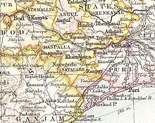
Ranpur State in the Imperial Gazetteer of India
Area 
 1931
526 km2 (203 sq mi)
Population 
 1931
47,711
History 
 Established
17th cen
1948
Succeeded by
India Flag of India.svg
View of the Ranpur palace, former residence of the ruling family of Ranpur. Owing to lack of maintenance it is currently in a much dilapidated condition. Ranpur palace, Ranpur, Raj-Ranpur, Odisha, India.JPG
View of the Ranpur palace, former residence of the ruling family of Ranpur. Owing to lack of maintenance it is currently in a much dilapidated condition.

Ranpur State was one of many small princely non-salute states of India during the period of the British Raj. It was one of the four native states located in present-day Nayagarh district, Odisha.

Contents

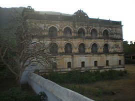
The state was bounded in the west by Nayagarh State and in all other directions by Puri district. It was very close to the seashore but had no coastline. Its southwestern part was thickly forested and was mostly uninhabited. The Ranpur ruling family claimed descent from the most ancient lineage of the princely rulers of the Orissa Tributary States. The capital of the state was Ranpur, a small town near Kalupara Ghat railway station where the Raja resided. [1] [2]

History

According to legendary tradition, Ranpur State is of very ancient origin. The legendary date of its foundation is placed some time in the 18th century BC [3] when the founder, a hunter named Basara Basuk, having defeated a giant demon named Ranasura, established his rule in the area. The name of the place is derived from the demon's name and was initially known as Ranasurapura, shortened to Ranpur in the course of time.

The Ranpur state rulers claimed to be the most ancient of all the lineages of the Orissa Tributary States, with a list of generations of rulers covering a period of 3,600 years with the Raja declaring indigenous origin in an inquiry in 1814. [1] According to the family history, the founder of the kingdom was Biswabasab, a Sabara who hailed from the Nilagiri hills region, established his rule in the region after subduing the Bhuiyas of the neighbouring villages. [4] Later the chiefs received the title of Narendra from the Eastern Ganga monarch Ananga Bhimadeva owing to his prowess in battle. [5]

Maratha Rule

In July 1764, Bhawani Bandit arrived in Orissa with a force of 5,000 horsemen. From the day of his arrival, Chirnna Sau entrusted the administration of Orissa to Bhawani Bandit, effectively making him the de facto Subahdar. Under Bhawani Bandit's leadership, the region saw a stabilization of power, including the suppression of the rebellious zamindar of Ranpur, thereby reinforcing Maratha control and ensuring a more orderly governance of the territory. [6]

The state became a British protectorate in 1803 after the British defeated the Marathas in the Second Anglo-Maratha War and took over the region. The last Raja of Ranpur signed the instrument of accession to the Indian Union, on 1 January 1948, [7] merging his state into Odisha

Rulers

The rulers of Ranpur State: [8]

Titular

See also

Related Research Articles

<span class="mw-page-title-main">Dhenkanal State</span> Princely state in Odisha, India

Dhenkanal State was one of the princely states of India during the period of the British Raj. The area of the former state is now referred to as Dhenkanal district, Odisha, with Dhenkanal town as its district headquarters.

<span class="mw-page-title-main">Patna State</span> Princely state of India

Patna State was a princely state in the Eastern States Agency of India during the British Raj. It had its capital at Balangir. Its area was 6,503 km2 (2,511 sq mi).

<span class="mw-page-title-main">Dashapalla</span> Town in Odisha, India

Dashapalla, also known as Daspalla, is an archaeologically important site situated in Nayagarh district, Odisha, India.

<span class="mw-page-title-main">Nilgiri State</span>

Nilagiri State was one of the princely states of India during the British Raj. It belonged to the Orissa States Agency and its capital was at Raj Nilgiri, which later became the modern town of Nilagiri.

<span class="mw-page-title-main">Raj-Ranpur</span>

Raj-Ranpur is a town and a Notified Area Council in the district of Nayagarh in the eastern Indian state of Odisha. The town is also known as Ranpurgarh or simply Ranpur as per the modern usage. The town is historically significant especially during the British Raj when it was the capital of the princely state of Ranpur. The martyrs Shaheed Raghu-Dibakar who were hanged for their resistance to British rule belong to this place. Rajsunakhala and Tangi are the nearest Town of Raj-Ranpur, which in almost 10 to 20 km from the town. Rajsunakhala is the most important business centre in Ranpur block under Nayagarh district.

<span class="mw-page-title-main">Saraikela State</span> Princely state of British India in modern-day Jharkhand

Saraikela State also spelt Seraikela, Saraikella or Seraikella, was a small princely state in India during the British Raj, in the region that is now the Jharkhand state. Its capital was at Saraikela.

<span class="mw-page-title-main">Hindol State</span>

Hindol State was one of the princely states of India during the British Raj. Its former territory is now part of Dhenkanal district. The state's former capital was the town of Hindol, Odisha. Until 1947, it was not part of British India but was subject to the suzerainty of the British crown, under the Orissa States Agency.

<span class="mw-page-title-main">Bonai State</span>

Bonai State was a minor princely state during the British Raj in what is today India. It was one of the Chota Nagpur States and had its capital at Bonaigarh, located in the present-day Sundergarh district of Odisha. It had an area of 8,907 square kilometres (3,439 sq mi) and a population of 24,026 in 1892 with an average annual revenue of Rs.60,000 in 1901.

<span class="mw-page-title-main">Talcher State</span>

Talcher State was one of the princely states of India during the British Raj. Talcher town in Angul District was the capital of the state and the seat of the Raja's residence. Its last ruler signed the accession to the Indian Union in 1948.

<span class="mw-page-title-main">Baramba State</span>

Baramba State was one of the princely states of India during the British Raj. It had its capital in Baramba town. The last ruler acceded to the Indian Union on 1 January 1948. Baramba state was made part of Cuttack district of Odisha in 1948.

<span class="mw-page-title-main">Daspalla State</span> Princely state of India during the British Raj

Daspalla State was one of the princely states of India during the period of the British Raj. Its capital was Kunjabangarh, located in present-day Nayagarh district, Odisha.

<span class="mw-page-title-main">Bhanja dynasty</span> Ancient dynasty originated in fhe Utkala Kingdom

The Bhanja dynasty is a dynasty that originated in the northern and central regions of modern Odisha before the Gupta Empire became an imperial power. The dynasty, of ancient local Kshatriya lineage as documented by Hermann Kulke, succeeded the Vindhyatabi branch of the Nagas of Padmavati, who ruled from the Keonjhar district of Odisha and included Satrubhanja of the Asanpat inscription. The Bhanj later became feudatories of the Bhauma-Kara dynasty.

<span class="mw-page-title-main">Mayurbhanj State</span> Princely state of British India in modern-day Odisha

Mayurbhanj State was one of the princely states of India during the British Raj. It was one of the largest states of the Eastern States Agency and one of the four salute states of the Orissa States Agency. The emblem of the state was two peacocks, for according to legend the ancestors of the rulers had originated from a peafowl's eyes.

<span class="mw-page-title-main">Khandpara State</span> Princely state in Odisha, India

Khandpara State was one of the princely states of India in the British Raj. It was located in present-day Nayagarh district, Odisha.

<span class="mw-page-title-main">Nayagarh State</span>

Nayagarh State was one of the princely states of India during the British Raj. It was located in present-day Nayagarh district, Odisha.

<span class="mw-page-title-main">Keonjhar State</span>

Keonjhar State, also known as Keunjhar, was one of the princely states of India during the period of the British Raj. The second largest of the states of the Orissa States Agency, it was located in present-day Kendujhar district, Odisha.

<span class="mw-page-title-main">Narsinghpur State</span> Princely state of India before 1948

Narsinghpur State was one of the princely states of India during the British Raj. The state was founded in the 17th century and had its capital in Narasinghpur town. The last ruler of Narsinghpur joined the state to the Indian Union in 1948 and Narsinghpur state was made part of the Cuttack district of Odisha.

<span class="mw-page-title-main">Tigiria State</span> State in India

Tigiria State was one of the princely states of India during the period of the British Raj. It was located in present-day Tigiria block of Cuttack district, Odisha. Although it was the smallest of the states of the Orissa States Agency it was the most densely populated. The last ruler of Tigiria joined the state to the Indian Union by signing the instrument of accession in 1948.

Kujang Estate was a small zamindari or estate located on the northern coast of the present-day state of Odisha in India. It was founded by Mallik Sandha, a teacher who established the Sandha dynasty. According to several sources, the Kujang kings enthusiastically patronized and spread education in their lands and played an important role in the Indian Independence Movement in Odisha.

References

  1. 1 2 Imperial Gazetteer of India, v. 21, p. 240.
  2. Great Britain India Office. The Imperial Gazetteer of India . Oxford: Clarendon Press, 1908.
  3. Ranpur (Princely State)
  4. Kanhu Charan Maharana (December 2014), Shakti Cult In Ranpur- A Case Study On Maninag Thakurani, Central India Journal of Historical And Archaeological Research CIJHAR, pp. 114–117
  5. Cobden Ramsay (1910), Bengal Gazetteers Feudatory States Of Orissa, DLI, p. 313
  6. Ray, Bhabani Charan (1960). Orissa Under Marathas 1751-1803. p. 39-40.
  7. ODISHA DISTRICT GAZETTEERS NAYAGARH (PDF), GAD, Govt of Odisha, 2015, pp. 39–45
  8. Princely States of India

19°54′N85°25′E / 19.900°N 85.417°E / 19.900; 85.417